
The Prospect of Whitby is a historic public house on the northern bank of the River Thames at Wapping, in the East End of London and the London Borough of Tower Hamlets. It lays claim to being on the site of the oldest riverside tavern, dating from around 1520.

The Jubilee line is a London Underground line that runs between Stanmore in suburban north-west London and Stratford in east London, via the Docklands, South Bank and West End. Opened in 1979, it is the newest line on the Underground network, although some sections of track date back to 1932 and some stations to 1879.

Wapping is an area in the borough of Tower Hamlets in London, England. It is in East London and part of the East End. Wapping is on the north bank of the River Thames between St Katharine Docks to the west, and Shadwell to the east. This position gives the district a strong maritime character.
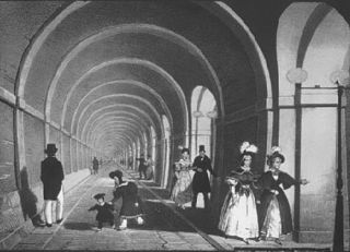
The Thames Tunnel is a tunnel beneath the River Thames in London, connecting Rotherhithe and Wapping. It measures 35 ft (11 m) wide by 20 ft (6.1 m) high and is 1,300 ft (400 m) long, running at a depth of 75 ft (23 m) below the river surface measured at high tide. It is the first tunnel known to have been constructed successfully underneath a navigable river. It was built between 1825 and 1843 by Marc Brunel, and his son, Isambard, using the tunnelling shield newly invented by the elder Brunel and Thomas Cochrane.

The Rotherhithe Tunnel, designated the A101, is a road tunnel under the River Thames in East London, connecting Limehouse in the London Borough of Tower Hamlets north of the river to Rotherhithe in the London Borough of Southwark south of the river. It was formally opened in 1908 by George, Prince of Wales, and Richard Robinson, Chairman of the London County Council. It is a rare example of a road tunnel where road traffic, pedestrians and cyclists all share the same tunnel bore. Transport for London took over ownership and maintenance of the tunnel in 2001.

Wapping is a station on the London overground located on the northern bank of the River Thames in Wapping within the London Borough of Tower Hamlets. The station is served by National Rail London Overground services under the control of the London Rail division of Transport for London, however there is no standard red National Rail "double arrow" logo signage located at the station, instead only the Overground roundel. The station is between Shadwell and Rotherhithe, and is in Travelcard Zone 2.
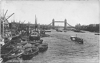
The Pool of London is a stretch of the River Thames from London Bridge to below Limehouse.

The London Docks were one of several sets of docks in the historic Port of London.

Billingsgate Fish Market is located in Poplar in London. It is the United Kingdom's largest inland fish market. It takes its name from Billingsgate, a ward in the south-east corner of the City of London, where the riverside market was originally established. In its original location in the 19th century, Billingsgate was the largest fish market in the world.

The Bristol Harbour Railway was a standard-gauge industrial railway that served the wharves and docks of Bristol, England. The line, which had a network of approximately 5 mi (8.0 km) of track, connected the Floating Harbour to the GWR mainline at Bristol Temple Meads. Freight could be transported directly by waggons to Paddington Station in London. The railway officially closed in 1964.
The EC postcode area, also known as the London EC postal area, is a group of postcode districts in central London, England. It includes almost all of the City of London and parts of the London boroughs of Islington, Camden, Hackney, Tower Hamlets and Westminster. The area covered is of very high density development. Deliveries for the EC postcode area are made from Mount Pleasant Mail Centre.

Shad Thames is a historic riverside street next to Tower Bridge in Bermondsey, London, England, and is also an informal name for the surrounding area. In the 19th century, the area included the largest warehouse complex in London.

Execution Dock was a site on the River Thames near the shoreline at Wapping, London, that was used for more than 400 years to execute pirates, smugglers and mutineers who had been sentenced to death by Admiralty courts. The "dock" consisted of a scaffold for hanging. Its last executions were in 1830.
Hammersmith Creek was an outflow river of the Stamford Brook, and used to run through what is now King Street, into the River Thames at the present-day site of Furnivall Gardens in Hammersmith.
There are several long-established Nordic churches in London. All seek to provide Lutheran Christian worship and pastoral care to their respective national communities in their own languages. Many of the churches also organise language classes and organise a wide range of social activities.
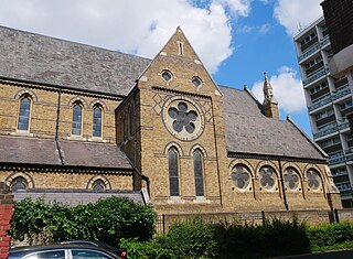
St Peter's, Wapping, is a Grade I listed Anglican church in Wapping Lane, Wapping, London, E1W 2RW.
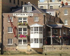
The Captain Kidd is a pub in Wapping, East London, that is named after the seventeenth century pirate William Kidd, who was executed at the nearby Execution Dock. The pub is a Grade II listed building, and was historically used as a coffee warehouse.
The New Cross to Finsbury Market Cable Tunnel is a 5.7-kilometre (3.5 mi) long, 2.85-metre diameter tunnel beneath London which carries power distribution cables for UK Power Networks as part of the London power distribution network. It was built between 2009 and 2017 by J. Murphy & Sons.
Rotherhithe Street is a road in the London Borough of Southwark on the Thames Path. At a length of around 1.5 miles (2.4 km), it is the longest street in London. Notable buildings on the street include the Grade II* listed Nelson House, St Mary's Church, Rotherhithe and Surrey Docks Farm.
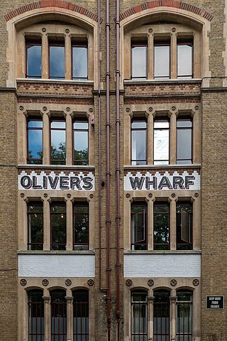
Oliver's Wharf is a Grade II listed apartment building and former warehouse on the River Thames in Wapping High Street, Wapping, London.
