Wat Ta Yom River

Last updated
Wat Ta Yom River
Country Thailand
Physical characteristics
Main source Noen Maprang District, Phitsanulok Province
River mouth Nan River in Phichit

The Wat Ta Yom River (Thai : แคววัดตายม) is a tributary of the Nan River in Thailand.

Thai language language spoken in Thailand

Thai, Central Thai, is the sole official and national language of Thailand and the first language of the Central Thai people and vast majority of Thai Chinese. It is a member of the Tai group of the Kra–Dai language family. Over half of Thai vocabulary is derived from or borrowed from Pali, Sanskrit, Mon and Old Khmer. It is a tonal and analytic language, similar to Chinese and Vietnamese.

Nan River river in Thailand

The Nan River is a river in Thailand. It is one of the most important tributaries of the Chao Phraya River.

Thailand Constitutional monarchy in Southeast Asia

Thailand, officially the Kingdom of Thailand and formerly known as Siam, is a country at the centre of the Southeast Asian Indochinese peninsula composed of 76 provinces. At 513,120 km2 (198,120 sq mi) and over 68 million people, Thailand is the world's 50th largest country by total area and the 21st-most-populous country. The capital and largest city is Bangkok, a special administrative area. Thailand is bordered to the north by Myanmar and Laos, to the east by Laos and Cambodia, to the south by the Gulf of Thailand and Malaysia, and to the west by the Andaman Sea and the southern extremity of Myanmar. Its maritime boundaries include Vietnam in the Gulf of Thailand to the southeast, and Indonesia and India on the Andaman Sea to the southwest. Although nominally a constitutional monarchy and parliamentary democracy, the most recent coup in 2014 established a de facto military dictatorship.

Contents

Geography

This river of many names originates in the mountains of the Noen Maprang District of Phitsanulok Province where it is referred to as the Chomphu River (Thai: คลองชมภู), [1] then flows through the Wang Thong District where it is referred to as the Tha Muen Ram River (Thai: แควน้ำท่าหมื่นราม), [2] then flows through the Bang Krathum District, through Wat Ta Yom, where it is referred to as the Wat Ta Yom River, [1] and drains into the Nan River in Phichit via the Tha Luang Canal (Thai: คลองท่าหลวง) at 16°26′27″N100°21′21″E / 16.44083°N 100.35583°E / 16.44083; 100.35583 . [3]

River Natural flowing watercourse

A river is a natural flowing watercourse, usually freshwater, flowing towards an ocean, sea, lake or another river. In some cases a river flows into the ground and becomes dry at the end of its course without reaching another body of water. Small rivers can be referred to using names such as stream, creek, brook, rivulet, and rill. There are no official definitions for the generic term river as applied to geographic features, although in some countries or communities a stream is defined by its size. Many names for small rivers are specific to geographic location; examples are "run" in some parts of the United States, "burn" in Scotland and northeast England, and "beck" in northern England. Sometimes a river is defined as being larger than a creek, but not always: the language is vague.

Phitsanulok Province Province in Thailand

Phitsanulok, one of Thailand's seventy-six provinces, lies in upper central Thailand. It borders Sukhothai and Uttaradit on the north, Loei and Phetchabun to the east, and Phichit and Kamphaeng Phet to the south. In the northeast it borders Laos.

Wat Ta Yom Tambon in Thailand

Wat Ta Yom is a subdistrict (tambon) in the Bang Krathum district of Phitsanulok Province, Thailand.

Etymology

Pali middle Indo-Aryan language

Pali or Magadhan is a Middle Indo-Aryan language native to the Indian subcontinent. It is widely studied because it is the language of the Pāli Canon or Tipiṭaka, and is the sacred language of some religious texts of Hinduism and all texts of Theravāda Buddhism. The earliest archaeological evidence of the existence of canonical Pali comes from Pyu city-states inscriptions found in Burma dated to the mid 5th to mid 6th century CE.

All of the above names of the river derive from the names of places through which the river flows or to which it leads. The river does not appear to have a geographically independent name of its own.

Tributaries

The following is a tree demonstrating the points at which the major tributaries of the Tha Luang River branch off from the main river and from each other. [1]

Gulf of Thailand A shallow inlet in the western part of the South China Sea

The Gulf of Thailand, also known as the Gulf of Siam, is a shallow inlet in the western part of the South China Sea, a marginal body of water in the western Pacific Ocean. The gulf is around 800 km (497 mi) long and up to 560 km (348 mi) wide, has a surface area of 320,000 km2 (123,553 sq mi) and is surrounded on the north, west and southwest by Thailand, on the northeast by Cambodia and Vietnam. The South China Sea is to the southeast.

Chao Phraya River main river in Thailand

The Chao Phraya is the major river in Thailand, with its low alluvial plain forming the centre of the country. It flows through Bangkok and then into the Gulf of Thailand.

Nakhon Sawan City Municipality in Thailand

Nakhon Sawan is a city in Thailand, the name literally means "Heavenly City". The city is the capital of Nakhon Sawan Province, and covers the complete subdistrict (tambon) Pak Nam Pho and parts of Khwae Yai, Nakhon Sawan Tok, Nakhon Sawan Ok and Wat Sai, all of Mueang Nakhon Sawan district. As of 2006 it has a population of 93,141. Nakhon Sawan is 238 km north of Bangkok.

Related Research Articles

Phichit Province Province in Thailand

Phichit is a province (changwat) of Thailand. It lies 330 km due north of Bangkok. Neighboring provinces are Phitsanulok, Phetchabun, Nakhon Sawan, and Kamphaeng Phet.

Bangkok Yai District Khet in Bangkok

Bangkok Yai is one of the 50 districts (khet) of Bangkok, Thailand. Neighbouring districts are Bangkok Noi, Phra Nakhon, Thon Buri, Phasi Charoen, and Taling Chan.

Yom River river in Thailand

The Yom River is a river in Thailand. It is the main tributary of the Nan River. The Yom River has its source in the Phi Pan Nam Range in Pong District, Phayao Province. Leaving Phayao, it flows through Phrae and Sukhothai as the main water resource of both provinces before it joins the Nan River at Chum Saeng District, Nakhon Sawan Province.

Bang Krathum District District in Phitsanulok, Thailand

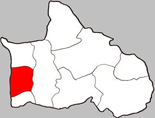
Bang Krathum is a district (amphoe) in the Phitsanulok Province, Thailand.

Bang Krathum Subdistrict Subdistrict in Thailand

Bang Krathum is a subdistrict (tambon) in the Bang Krathum district of Phitsanulok Province, Thailand.

Mueang Phitsanulok District District in Phitsanulok, Thailand

Mueang Phitsanulok is the capital district of Phitsanulok Province, central Thailand.

Wang Thong District District in Phitsanulok, Thailand

Wang Thong is a district (amphoe) of Phitsanulok Province, central Thailand.

Wang Thong River river in Thailand

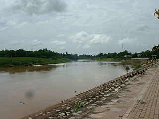
The Wang Thong River is a river in Thailand. Its source lies in the Phetchabun Mountains in the Khao Kho District, Thailand. It flows through Thung Salaeng Luang National Park and forms Namtok Sri Dit and Namtok Kaeng Sopha in the Wang Thong District of Phitsanulok Province, and finally flows through into the Bang Krathum District, passing through Ban Sam Ruen and on to the border of Phitsanulok and Phichit, where it drains into the Nan River at 16°31′06″N100°19′36″E. The land drained by the Wang Thong River is part of the Nan Basin and the Chao Phraya Watershed.

Noen Kum Tambon in Thailand

Noen Kum is a subdistrict (tambon) in the Bang Krathum district of Phitsanulok Province, Thailand.

Phai Lom, Phitsanulok Tambon in Thailand

Phai Lom is a subdistrict (tambon) in the Bang Krathum district of Phitsanulok Province, Thailand.

Ban Rai, Phitsanulok Tambon in Thailand

Ban Rai is a subdistrict (tambon) in the Bang Krathum district of Phitsanulok Province, Thailand.

Khok Salut Tambon in Thailand

Kok Salud is a subdistrict (tambon) in the Bang Krathum district of Phitsanulok Province, Thailand.

Sanam Khli Tambon in Thailand

Sanam Khli is a sub-district (tambon) in the Bang Krathum District of Phitsanulok Province (amphoe), Thailand.

Tha Tan Tambon in Thailand

Tha Tan is a sub-district (tambon) in the Bang Krathum District of Phitsanulok Province, Thailand.

Topographical features within the Phitsanulok Province of Thailand include the Phetchabun Mountains, the Nan River and several of its tributaries, waterfalls, swamps, forests, grasslands, caves, a reservoir and an extensive network of canals. Populated areas of the province are largely cleared of natural vegetation and adapted for farming. The land in the province is in the Greater Nan Basin, which is part of the Chao Phraya Watershed. The province includes land within both of the greater Nan basin's sub-basins, i.e., the Nan Basin and Yom Basin. The provincial capital of Phitsanulok is sometimes called Song Kwae, the "city of two rivers", an ancient name dating to a time centuries ago when the Nan and Khwae Noi Rivers met near the city. These two rivers of the Phitsanulok Province are still of major significance to the residents of the region.

Siri Rat Subdistrict subdistrict in Bangkok Noi district, Bangkok, Thailand

Siri Rat is one of the 180 sub-districts (khwaeng) of Bangkok, Thailand, covering the area around Siriraj Hospital, located on the southern rim of Khlong (canal) Bangkok Noi mouth to the western bank of the Chao Phraya River in Bangkok Noi District. It is also named for the road intersection of Thanon (Road) Arun Ammarin and Thanon Wang Lang at the front of the hospital.

References