Related Research Articles

A swamp is a forested wetland. Swamps are considered to be transition zones because both land and water play a role in creating this environment. Swamps vary in size and are located all around the world. The water of a swamp may be fresh water, brackish water, or seawater. Freshwater swamps form along large rivers or lakes where they are critically dependent upon rainwater and seasonal flooding to maintain natural water level fluctuations. Saltwater swamps are found along tropical and subtropical coastlines. Some swamps have hammocks, or dry-land protrusions, covered by aquatic vegetation, or vegetation that tolerates periodic inundation or soil saturation. The two main types of swamp are "true" or swamp forests and "transitional" or shrub swamps. In the boreal regions of Canada, the word swamp is colloquially used for what is more formally termed a bog, fen, or muskeg. Some of the world's largest swamps are found along major rivers such as the Amazon, the Mississippi, and the Congo.
Natural Resources Conservation Service (NRCS), formerly known as the Soil Conservation Service (SCS), is an agency of the United States Department of Agriculture (USDA) that provides technical assistance to farmers and other private landowners and managers.

A Ramsar site is a wetland site designated to be of international importance under the Ramsar Convention, also known as "The Convention on Wetlands", an international environmental treaty signed on 2 February 1971 in Ramsar, Iran, under the auspices of UNESCO. It came into force on 21 December 1975, when it was ratified by a sufficient number of nations. It provides for national action and international cooperation regarding the conservation of wetlands, and wise sustainable use of their resources. Ramsar treaty participants meet regularly to identify and agree to protect "Wetlands of International Importance", especially those providing waterfowl habitat.

Located in northern California, the Suisun Marsh has been referred to as the largest brackish water marsh on west coast of the United States of America. The marsh land is part of a tidal estuary, and subject to tidal ebb and flood. The marsh is home to many species of birds and other wildlife, and is formed by the confluence of the Sacramento and San Joaquin rivers between Martinez and Suisun City, California and several other smaller, local watersheds. Adjacent to Suisun Bay, the marsh is immediately west of the legally defined Sacramento-San Joaquin Delta as well as part of the San Francisco Bay estuary.

The Conservation Reserve Program (CRP) is a cost-share and rental payment program of the United States Department of Agriculture (USDA). Under the program, the government pays farmers to take certain agriculturally used croplands out of production and convert them to vegetative cover, such as cultivated or native bunchgrasses and grasslands, wildlife and pollinators food and shelter plantings, windbreak and shade trees, filter and buffer strips, grassed waterways, and riparian buffers. The purpose of the program is to reduce land erosion, improve water quality and effect wildlife benefits.

Mission Bay is an artificial, saltwater bay located south of the Pacific Beach community of San Diego, California, created from approximately 2,000 acres (810 ha) of historical wetland, marsh, and saltwater bay habitat. The bay is part of the recreational Mission Bay Park, the largest man-made aquatic park in the United States, consisting of 4,235 acres (17.14 km2), approximately 46% land and 54% water. The combined area makes Mission Bay Park the ninth largest municipally-owned park in the United States.
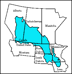
The Prairie Pothole Region (PPR) is an expansive area of the northern Great Plains that contains thousands of shallow wetlands known as potholes. These potholes are the result of glacier activity in the Wisconsin glaciation, which ended about 10,000 years ago. The decaying ice sheet left behind depressions formed by the uneven deposition of till as buried ice blocks melted in ground moraines. These depressions are called potholes, glacial potholes, kettles, or kettle lakes. They fill with water in the spring, creating wetlands, which range in duration from temporary to semi-permanent. The region covers an area of about 800,000 sq. km and expands across three Canadian provinces and five U.S. states. The hydrology of the wetlands is variable, which results in long term productivity and biodiversity. The PPR is a prime spot during breeding and nesting season for millions of migrating waterfowl.

Bolsa Chica State Ecological Reserve is a natural reserve and public land in Orange County, governed by the state of California, and immediately adjacent to the city of Huntington Beach, California. The reserve is designated by the California Department of Fish and Wildlife (CDFW) to protect a coastal wetland and upland, with both migratory and resident threatened and endangered species of wildlife and wildflowers.
The Staaten River is a river in northern Queensland, Australia, rising in the Great Dividing Range and flowing northwest into the Gulf of Carpentaria.

Jackson Bottom Wetlands Preserve in Hillsboro, Oregon, United States, is a 635-acre (257 ha) wetlands area along the Tualatin River in Washington County, Oregon. Located on the south end of the city along Highway 219, this lowland area is a designated Important Bird Area and hosts such birds as buffleheads, dusky Canada geese, and tundra swans.

The Creston Valley Wildlife Management Area is a Canadian river delta wetland and Wildlife Management Area near Creston in south-central British Columbia, on the floodplain of the Kootenay River at the south end of Kootenay Lake. Predominantly marshland, it was classified as a wetland of international importance on February 21, 1994, and is also a globally significant Important Bird Area. It is one of the "few significant agricultural areas of the province", and is in the Montane Cordillera. It stretches north along Kootenay Lake for approximately 20 km, and south to the United States border. It is both the only breeding site of the Forster's tern and the only site with leopard frogs in the province, as well as one of the few Canadian habitats for the Coeur D'Alene salamander. Creston Valley provides staging and nesting areas for migratory birds on the Pacific Flyway.

Mitigation banking is a market-based system of debits and credits that involves restoration, creation, or enhancement of wetlands to compensate for unavoidable impacts to a wetland in another location. It involves a system of mitigation banks, sites where projects to restore, create, or enhance wetlands can be carried out in advance of impacts. The outcomes of these projects are valued through the creation of compensatory mitigation credits that can be purchased from mitigation banks to offset the negative impacts of developments or agriculture expansion on wetlands and aquatic habitats. This process is generally conducted with the aim of achieving no net loss of function and value for specific aquatic habitats, such as in terms of the biodiversity or ecosystem services provided by a wetland.
A converted wetland is one that has been drained, dredged, filled, leveled, or otherwise altered for the production of an agricultural commodity. The definition is part of The Highly Erodible Land Conservation and Wetland Conservation Compliance provisions (Swampbuster) introduced in the 1985 Farm Bill. The provisions aim to reduce soil loss on erosion-prone lands and to protect wetlands for the multiple benefits they provide.

"No Net loss" is the United States government's overall policy goal regarding wetlands preservation. The goal of the policy is to balance wetland loss due to economic development with wetlands reclamation, mitigation, and restorations efforts, so that the total acreage of wetlands in the country does not decrease, but remains constant or increases.

The Summer Lake Wildlife Area is a 29.6-square-mile (77 km2) wildlife refuge located on the northwestern edge of the Great Basin drainage in south-central Oregon. It is administered by the Oregon Department of Fish and Wildlife. The refuge is an important stop for waterfowl traveling along the Pacific Flyway during their spring and fall migrations. The Summer Lake Wildlife Area also provides habitat for shorebirds and other bird species as well as wide variety of mammals and several fish species. The Ana River supplies the water for the refuge wetlands.
Oaks Bottom Wildlife Refuge is a city park of about 141 acres (57 ha) in southeast Portland, in the U.S. state of Oregon. Located in a floodplain along the east bank of the Willamette River near Sellwood, the park is known for attracting a wide variety of birds. In 1988, the park was named Portland's first wildlife refuge, and in 2004, it was designated the city's first migratory bird park.

The Coongie Lakes is a freshwater wetland system located in the Far North region of South Australia. The 21,790-square-kilometre (8,410 sq mi) lakes system is located approximately 1,046 kilometres north of the Adelaide city centre. The wetlands includes lakes, channels, billabongs, shallow floodplains, deltas, and interdune swamps. It lies on the floodplain of Cooper Creek, an ephemeral river flowing through a desert landscape in the Lake Eyre Basin which rarely, after occasional large floods, empties into Lake Eyre. The wetland system has been recognised both as being of international importance by designation under the Ramsar Convention with a listing on 15 June 1987 and being nationally important within Australia with a listing in A Directory of Important Wetlands in Australia (DIWA). Its extent includes the regional town of Innamincka, the Malkumba-Coongie Lakes National Park, the Innamincka Regional Reserve, the Strzelecki Regional Reserve and the Coongie Lakes Important Bird Area.

Thrissur-Ponnani Kole Wetlands is a wetland lying in Thrissur and Malappuram districts in Kerala, India. It gives 40 per cent of the Kerala’s rice requirement and acts as a natural drainage system for Ponnani city, Thrissur city, Thrissur District, and Malappuram district. The Kole Wetlands is one of largest, highly productive and threatened wetlands in Kerala and lie on the Central Asian Flyway of migratory birds.

Mattaponi Wildlife Management Area is a 2,542-acre (10.29 km2) Wildlife Management Area (WMA) in Caroline County, Virginia. Located west of Bowling Green, the area protects a mixture of wetlands and upland forests at the confluence of the Mattaponi and South rivers.

The Botany Water Reserves is a heritage-listed area that was historically used as part of Sydney's water supply system. It is located at 1024 Botany Road, Mascot,New South Wales, Australia. The site is now reserved as parkland, also containing a golf course. It was designed by City Engineers, W. B. Rider, E. Bell (1856–1871), and Francis Bell (1871–1878). It is also known as Botany Dams, Botany Swamps, Botany Wetlands, Mill Stream, Bridge Pond, The Lakes Golf Club, Eastlakes Golf Course, Bonnie Doon Golf Club, and Astrolabe Park. The property is owned by Sydney Water, an agency of the Government of New South Wales. It was added to the New South Wales State Heritage Register on 18 November 1999.
References
 This article incorporates public domain material from Jasper Womach. Report for Congress: Agriculture: A Glossary of Terms, Programs, and Laws, 2005 Edition (PDF). Congressional Research Service.
| | This article related to a protected area in the United States is a stub. You can help Wikipedia by expanding it. |