
Canals or artificial waterways are waterways or engineered channels built for drainage management or for conveyancing water transport vehicles. They carry free, calm surface flow under atmospheric pressure, and can be thought of as artificial rivers.

A road is a linear way for the conveyance of traffic that typically has an improved surface for use by vehicles and pedestrians. Unlike streets, the primary function of roads is transportation.

A beach is a landform alongside a body of water which consists of loose particles. The particles composing a beach are typically made from rock, such as sand, gravel, shingle, pebbles, etc., or biological sources, such as mollusc shells or coralline algae. Sediments settle in different densities and structures, depending on the local wave action and weather, creating different textures, colors and gradients or layers of material.

Traffic comprises pedestrians, vehicles, ridden or herded animals, trains, and other conveyances that use public ways (roads) for travel and transportation.

Drainage is the natural or artificial removal of a surface's water and sub-surface water from an area with excess of water. The internal drainage of most agricultural soils is good enough to prevent severe waterlogging, but many soils need artificial drainage to improve production or to manage water supplies.

A highway is any public or private road or other public way on land. It is used for major roads, but also includes other public roads and public tracks. In some areas of the United States, it is used as an equivalent term to controlled-access highway, or a translation for autobahn, autoroute, etc.

The River Welland is a lowland river in the east of England, some 65 miles (105 km) long. It drains part of the Midlands eastwards to The Wash. The river rises in the Hothorpe Hills, at Sibbertoft in Northamptonshire, then flows generally northeast to Market Harborough, Stamford and Spalding, to reach The Wash near Fosdyke. It is a major waterway across the part of the Fens called South Holland, and is one of the Fenland rivers which were laid out with washlands. There are two channels between widely spaced embankments with the intention that flood waters would have space in which to spread while the tide in the estuary prevented free egress. However, after the floods of 1947, new works such as the Coronation Channel were constructed to control flooding in Spalding and the washes are no longer used solely as pasture, but may be used for arable farming.
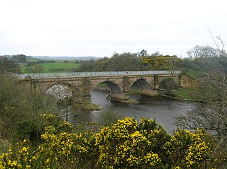
A viaduct is a specific type of bridge that consists of a series of arches, piers or columns supporting a long elevated railway or road. Typically a viaduct connects two points of roughly equal elevation, allowing direct overpass across a wide valley, road, river, or other low-lying terrain features and obstacles. The term viaduct is derived from the Latin via meaning "road", and ducere meaning "to lead". It is a 19th-century derivation from an analogy with ancient Roman aqueducts. Like the Roman aqueducts, many early viaducts comprised a series of arches of roughly equal length.

A storm drain, storm sewer, surface water drain/sewer, or stormwater drain is infrastructure designed to drain excess rain and ground water from impervious surfaces such as paved streets, car parks, parking lots, footpaths, sidewalks, and roofs. Storm drains vary in design from small residential dry wells to large municipal systems.

Suspension is the system of tires, tire air, springs, shock absorbers and linkages that connects a vehicle to its wheels and allows relative motion between the two. Suspension systems must support both road holding/handling and ride quality, which are at odds with each other. The tuning of suspensions involves finding the right compromise. It is important for the suspension to keep the road wheel in contact with the road surface as much as possible, because all the road or ground forces acting on the vehicle do so through the contact patches of the tires. The suspension also protects the vehicle itself and any cargo or luggage from damage and wear. The design of front and rear suspension of a car may be different.

A fire-tube boiler is a type of boiler in which hot gases pass from a fire through one or more tubes running through a sealed container of water. The heat of the gases is transferred through the walls of the tubes by thermal conduction, heating the water and ultimately creating steam.

A water-meadow is an area of grassland subject to controlled irrigation to increase agricultural productivity. Water-meadows were mainly used in Europe from the 16th to the early 20th centuries. Working water-meadows have now largely disappeared, but the field patterns and water channels of derelict water-meadows remain common in areas where they were used, such as parts of Northern Italy, Switzerland and England. Derelict water-meadows are often of importance as wetland wildlife habitats.

A gravel road is a type of unpaved road surfaced with gravel that has been brought to the site from a quarry or stream bed. They are common in less-developed nations, and also in the rural areas of developed nations such as Canada and the United States. In New Zealand, and other Commonwealth countries, they may be known as metal roads. They may be referred to as "dirt roads" in common speech, but that term is used more for unimproved roads with no surface material added. If well constructed and maintained, a gravel road is an all-weather road.

The Petaluma River is a river in the California counties of Sonoma and Marin that becomes a tidal slough for most of its length. The headwaters are in the area southwest of Cotati. The flow is generally southward through Petaluma's old town, where the waterway becomes navigable, and then flows another 10 mi (16 km) through tidal marshes before emptying into the northwest corner of San Pablo Bay.
The River Roach is a river that flows entirely through the English county of Essex. It is one of four main streams that originate in the Rayleigh Hills to the west, and flow east. They then flow towards the centre of the Rochford Basin, a circular feature which may have been caused by an asteroid impact in the Late Oligocene or Early Miocene periods. To the east of Rochford, the river becomes tidal, and is governed by the Crouch Harbour Authority. It joins the River Crouch between Wallasea Island and Foulness Island. To the west of Rochford, there is some doubt as to which of the four streams is officially the Roach.
Landslide mitigation refers to several man-made activities on slopes with the goal of lessening the effect of landslides. Landslides can be triggered by many, sometimes concomitant causes. In addition to shallow erosion or reduction of shear strength caused by seasonal rainfall, landslides may be triggered by anthropic activities, such as adding excessive weight above the slope, digging at mid-slope or at the foot of the slope. Often, individual phenomena join together to generate instability over time, which often does not allow a reconstruction of the evolution of a particular landslide. Therefore, landslide hazard mitigation measures are not generally classified according to the phenomenon that might cause a landslide. Instead, they are classified by the sort of slope stabilization method used:

Surface irrigation is where water is applied and distributed over the soil surface by gravity. It is by far the most common form of irrigation throughout the world and has been practiced in many areas virtually unchanged for thousands of years.

A check dams is a small, sometimes temporary, dam constructed across a swale, drainage ditch, or waterway to counteract erosion by reducing water flow velocity. Check dams themselves are not a type of new technology; rather, they are an ancient technique dating from the second century A.D. Check dams are typically, though not always, implemented in a system of several dams situated at regular intervals across the area of interest.
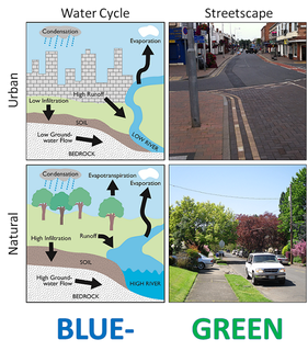
Water-sensitive urban design (WSUD) is a [[land planning] and engineering design approach which integrates the urban water cycle, including stormwater, groundwater, and wastewater management and water supply, into urban design to minimise environmental degradation and improve aesthetic and recreational appeal. WSUD is a term used in the Middle East and Australia and is similar to low-impact development (LID), a term used in the United States; and Sustainable Drainage System (SuDS), a term used in the United Kingdom.

Terminology related to road transport—the transport of passengers or goods on paved routes between places—is diverse, with variation between dialects of English. There may also be regional differences within a single country, and some terms differ based on the side of the road traffic drives on. This glossary is an alphabetical listing of road transport terms.

