Related Research Articles

The coast, also known as the coastline or seashore, is defined as the area where land meets the sea or ocean, or as a line that forms the boundary between the land and the ocean or a lake. Around 620,000 kilometres (390,000 mi) of coastline are on Earth. Because of the coastline paradox, a coastline's exact perimeter cannot be determined.

In earth science, erosion is the action of surface processes that removes soil, rock, or dissolved material from one location on the Earth's crust, and then transports it to another location. This natural process is caused by the dynamic activity of erosive agents, that is, water, ice (glaciers), snow, air (wind), plants, animals, and humans. In accordance with these agents, erosion is sometimes divided into water erosion, glacial erosion, snow erosion, wind (aeolic) erosion, zoogenic erosion, and anthropogenic erosion. The particulate breakdown of rock or soil into clastic sediment is referred to as physical or mechanical erosion; this contrasts with chemical erosion, where soil or rock material is removed from an area by its dissolving into a solvent, followed by the flow away of that solution. Eroded sediment or solutes may be transported just a few millimetres, or for thousands of kilometres.

A beach is a landform alongside a body of water which consists of loose particles. The particles composing a beach are typically made from rock, such as sand, gravel, shingle, pebbles. The particles can also be biological in origin, such as mollusc shells or coralline algae.

Coastal erosion is the loss or displacement of land, or the long-term removal of sediment and rocks along the coastline due to the action of waves, currents, tides, wind-driven water, waterborne ice, or other impacts of storms. The landward retreat of the shoreline can be measured and described over a temporal scale of tides, seasons, and other short-term cyclic processes. Coastal erosion may be caused by hydraulic action, abrasion, impact and corrosion by wind and water, and other forces, natural or unnatural.

A stack or sea stack is a geological landform consisting of a steep and often vertical column or columns of rock in the sea near a coast, formed by wave erosion. Stacks are formed over time by wind and water, processes of coastal geomorphology. They are formed when part of a headland is eroded by hydraulic action, which is the force of the sea or water crashing against the rock. The force of the water weakens cracks in the headland, causing them to later collapse, forming free-standing stacks and even a small island. Without the constant presence of water, stacks also form when a natural arch collapses under gravity, due to sub-aerial processes like wind erosion. Erosion causes the arch to collapse, leaving the pillar of hard rock standing away from the coast—the stack. Eventually, erosion will cause the stack to collapse, leaving a stump. Stacks can provide important nesting locations for seabirds, and many are popular for rock climbing.
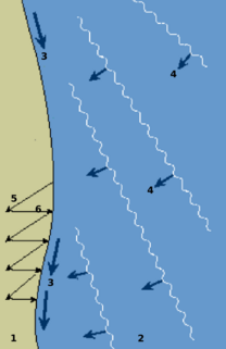
Longshore drift from longshore current is a geological process that consists of the transportation of sediments along a coast parallel to the shoreline, which is dependent on oblique incoming wave direction. Oblique incoming wind squeezes water along the coast, and so generates a water current which moves parallel to the coast. Longshore drift is simply the sediment moved by the longshore current. This current and sediment movement occur within the surf zone.

Coastal geography is the study of the constantly changing region between the ocean and the land, incorporating both the physical geography and the human geography of the coast. It includes understanding coastal weathering processes, particularly wave action, sediment movement and weather, and the ways in which humans interact with the coast

Hydraulic action is the erosion that occurs when the motion of water against a rock surface produces mechanical weathering. Most generally, it is the ability of moving water to dislodge and transport rock particles. Within this rubric are a number of specific erosional processes, including abrasion, at facilitated erosion, such as static erosion where water leaches salts and floats off organic material from unconsolidated sediments, and from chemical erosion more often called chemical weathering. It is a mechanical process, in which the moving water current flows against the banks and bed of a river, thereby removing rock particles.

Coastal management is defence against flooding and erosion, and techniques that stop erosion to claim lands.

Downcutting, also called erosional downcutting, downward erosion or vertical erosion is a geological process by hydraulic action that deepens the channel of a stream or valley by removing material from the stream's bed or the valley's floor. The speed of downcutting depends on the stream's base level, the lowest point to which the stream can erode. Sea level is the ultimate base level, but many streams have a higher "temporary" base level because they empty into another body of water that is above sea level or encounter bedrock that resists erosion. A concurrent process called lateral erosion refers to the widening of a stream channel or valley. When a stream is high above its base level, downcutting will take place faster than lateral erosion; but as the level of the stream approaches its base level, the rate of lateral erosion increases. This is why streams in mountainous areas tend to be narrow and swift, forming V-shaped valleys, while streams in lowland areas tend to be wide and slow-moving, with valleys that are correspondingly wide and flat-bottomed. The term gradient refers to the elevation of a stream relative to its base level. The steeper the gradient, the faster the stream flows. Sometimes geological uplift will increase the gradient of a stream even while the stream downcuts toward its base level, a process called "rejuvenation." This happened in the case of the Colorado River in the western United States, resulting in the process that created the Grand Canyon.
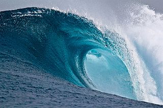
In fluid dynamics, a breaking wave or breaker is a wave whose amplitude reaches a critical level at which some process can suddenly start to occur that causes large amounts of wave energy to be transformed into turbulent kinetic energy. At this point, simple physical models that describe wave dynamics often become invalid, particularly those that assume linear behaviour.

Abrasion is a process of erosion which occurs when material being transported wears away at a surface over time. It is the process of friction caused by scuffing, scratching, wearing down, marring, and rubbing away of materials. The intensity of abrasion depends on the hardness, concentration, velocity and mass of the moving particles. Abrasion generally occurs four ways. Glaciation slowly grinds rocks picked up by ice against rock surfaces. Solid objects transported in river channels make abrasive surface contact with the bed and walls. Objects transported in waves breaking on coastlines cause abrasion. And, finally, abrasion can be caused by wind transporting sand or small stones against surface rocks.
Beach evolution occurs at the shoreline where sea, lake or river water is eroding the land. Beaches exist where sand accumulated from centuries-old, recurrent processes that erode rocky and sedimentary material into sand deposits. River deltas deposit silt from upriver, accreting at the river's outlet to extend lake or ocean shorelines. Catastrophic events such as tsunamis, hurricanes, and storm surges accelerate beach erosion.

Sand dunes are common features of shoreline and desert environments. Dunes provide habitat for highly specialized plants and animals, including rare and endangered species. They can protect beaches from erosion and recruit sand to eroded beaches. Dunes are threatened by human activity, both intentional and unintentional. Countries such as the United States, Australia, Canada, New Zealand, the United Kingdom, and Netherlands, operate significant dune protection programs.

A surf break is a permanent obstruction such as a coral reef, rock, shoal, or headland that causes a wave to break, forming a barreling wave or other wave that can be surfed, before it eventually collapses. The topography of the seabed determines the shape of the wave and type of break. Since shoals can change size and location, affecting the break, it takes commitment and skill to find good breaks. Some surf breaks are quite dangerous, since the surfer can collide with a reef or rocks below the water.
The Canterbury Bight is a large bight on the eastern side of New Zealand's South Island. The bight runs for approximately 135 kilometres (84 mi) from the southern end of Banks Peninsula to the settlement of Timaru and faces southeast, exposing it to high-energy storm waves originating in the Pacific Ocean. The bight is known for rough conditions as a result, with wave heights of over 2 metres (6.6 ft) common. Much of the bight's geography is shaped by this high-energy environment interacting with multiple large rivers which enter the Pacific in the bight, such as the Rakaia, Ashburton / Hakatere, and Rangitata Rivers. Sediment from these rivers, predominantly Greywacke, is deposited along the coast and extends up to 50 kilometres (31 mi) out to sea from the current shoreline. Multiple hapua, or river-mouth lagoons, can be found along the length of the bight where waves have deposited sufficient sediment to form a barrier across a river mouth, including most notably Lake Ellesmere / Te Waihora and Washdyke Lagoon

A cliffed coast, also called an abrasion coast, is a form of coast where the action of marine waves has formed steep cliffs that may or may not be precipitous. It contrasts with a flat or alluvial coast.

Dynamic revetment, also known as a "cobble berm", uses gravel or cobble-sized rocks to mimic a natural cobble storm beach for the purpose of reducing wave energy and stopping or slowing coastal erosion. Unlike seawalls, dynamic revetment is designed to allow wave action to rearrange the stones into an equilibrium profile, disrupting wave action and dissipating wave energy as the cobbles move. This can reduce the wave reflection which often contributes to beach scouring.

Hapua is the Māori term for river-mouth lagoons on mixed sand and gravel (MSG) beaches which form at the river-coast interface where a typically braided, although sometimes meandering, river interacts with a coastal environment that is significantly affected by longshore drift. The lagoons which form on the MSG coastlines are common on the east coast of the South Island of New Zealand and have long been referred to as hapua by the Māori. This classification differentiates hapua from similar lagoons located on the New Zealand coast termed waituna. Hapua are often located on paraglacial coastal areas where there is a low level of coastal development and minimal population density. Hapua form as the river carves out an elongated coast-parallel area, blocked from the sea by a MSG barrier which constantly alters its shape and volume due to longshore drift. Longshore drift continually extends the barrier behind which the hapua forms by transporting sediment along the coast. Hapua are defined as a narrow shore-parallel extensions of the coastal riverbed. They discharge the majority of stored water to the ocean via an ephemeral and highly mobile drainage channel or outlet. The remainder percolates through the MSG barrier due to its high levels of permeability. Hapua systems are driven by a wide range of dynamic processes that are generally classified as fluvial or marine; changes in the balance between these processes as well as the antecedent barrier conditions can cause shifts in the morphology of the hapua, in particular the barrier. New Zealand examples include the Rakaia, Ashburton and Hurunui river-mouths.
References
- David Waugh (2000). Geography: An Integrated Approach. Nelson Thornes. p. 149. ISBN 978-0-17-444706-1.