
The Erie Canal is a canal in New York, United States that is part of the east–west, cross-state route of the New York State Canal System. Originally, it ran 363 miles (584 km) from where Albany meets the Hudson River to where Buffalo meets Lake Erie. It was built to create a navigable water route from New York City and the Atlantic Ocean to the Great Lakes. When completed in 1825, it was the second longest canal in the world and greatly affected the development and economy of New York, New York City, and the United States.

A lock is a device used for raising and lowering boats, ships and other watercraft between stretches of water of different levels on river and canal waterways. The distinguishing feature of a lock is a fixed chamber in which the water level can be varied; whereas in a caisson lock, a boat lift, or on a canal inclined plane, it is the chamber itself that rises and falls.

The Chesapeake & Delaware Canal is a 14-mile (22.5 km)-long, 450-foot (137.2 m)-wide and 35-foot (10.7 m)-deep ship canal that connects the Delaware River with the Chesapeake Bay in the states of Delaware and Maryland in the United States. The C&D Canal is owned and operated by the U.S. Army Corps of Engineers, Philadelphia District. The project office in Chesapeake City, Maryland, is also the site of the C&D Canal Museum and Bethel Bridge Lighthouse. In Delaware, the canal is itself a significant landmark and cultural boundary, considered a divide between the urbanized northern portion of the state and the rural southern portion, and demarcates an unofficial northern limit to the Delmarva Peninsula.
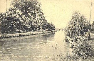
The Miami and Erie Canal was a 274-mile (441 km) canal that ran from Cincinnati to Toledo, Ohio, creating a water route between the Ohio River and Lake Erie. Construction on the canal began in 1825 and was completed in 1845 at a cost to the state government of $8,062,680.07. At its peak, it included 19 aqueducts, three guard locks, 103 canal locks, multiple feeder canals, and a few man-made water reservoirs. The canal climbed 395 feet (120 m) above Lake Erie and 513 feet (156 m) above the Ohio River to reach a topographical peak called the Loramie Summit, which extended 19 miles (31 km) between New Bremen, Ohio to lock 1-S in Lockington, north of Piqua, Ohio. Boats up to 80 feet long were towed along the canal by mules, horses, or oxen walking on a prepared towpath along the bank, at a rate of four to five miles per hour.

The Ohio and Erie Canal was a canal constructed during the 1820s and early 1830s in Ohio. It connected Akron with the Cuyahoga River near its outlet on Lake Erie in Cleveland, and a few years later, with the Ohio River near Portsmouth. It also had connections to other canal systems in Pennsylvania.

The New York State Canal System is a successor to the Erie Canal and other canals within New York. Currently, the 525-mile (845 km) system is composed of the Erie Canal, the Oswego Canal, the Cayuga–Seneca Canal, and the Champlain Canal. In 2014 the system was listed as a national historic district on the National Register of Historic Places in its entirety, and in 2016 it was designated a National Historic Landmark.

The Cayuga–Seneca Canal is a canal in New York, United States. It is now part of the New York State Canal System.

The Oswego Canal is a canal in the New York State Canal System located in New York, United States. Opened in 1828, it is 23.7 miles (38.1 km) in length, and connects the Erie Canal at Three Rivers to Lake Ontario at Oswego. The canal has a depth of 14 ft, with seven locks spanning the 118 ft change in elevation.

The Champlain Canal is a 60-mile (97 km) canal that connects the south end of Lake Champlain to the Hudson River in New York. It was simultaneously constructed with the Erie Canal and is now part of the New York State Canal System and the Lakes to Locks Passage.
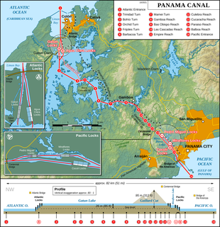
The Panama Canal locks are a lock system that lifts a ship up 85 feet to the main elevation of the Panama Canal and down again. The original canal had a total of six steps for a ship's passage. The total length of the lock structures, including the approach walls, is over 1.9 miles (3 km). The locks were one of the greatest engineering works ever to be undertaken when they opened in 1914. No other concrete construction of comparable size was undertaken until the Hoover Dam, in the 1930s.
The Commission to Explore a Route for a Canal to Lake Erie and Report, known as the Erie Canal Commission, was a body created by the New York State Legislature in 1810 to plan the Erie Canal. In 1817 a Canal Fund led by Commissioners of the Canal Fund was established to oversee the funding of construction of the canal. In 1826 a Canal Board, of which both the planning commissioners and the Canal Fund commissioners were members, was created to take control of the operational canal. The term "Canal Commission" was at times applied to any of these bodies. Afterwards the canal commissioners were minor state cabinet officers responsible for the maintenance and improvements of the state's canals.

The Erie Canal Museum is a historical museum about the Erie Canal located in Syracuse, New York. The museum was founded in 1962 and is a private, non-profit corporation. It is housed in the Syracuse Weighlock Building dating from 1850. The Syracuse Weighlock Building was in operation as a weighlock from 1850 to 1883. In 1883 the canal decided to stop charging tolls. The weighlock building was essentially used as a big, elaborate scale to weigh the boats traveling on the Erie Canal and determine how much each boat would pay for a toll. Today the museum includes not only artifacts from the Erie Canal, but also a gallery of present canal life. It is the mission of the museum to help people to learn the rich history of the Erie Canal and that it is not just a thing of the past, but still very much exists today in different forms.

The Lehigh Canal or the Lehigh Navigation Canal is a navigable canal, beginning at the mouth of Nesquehoning Creek on the Lehigh River in Eastern Pennsylvania. It was built in two sections over a span of twenty years, beginning in 1818. The lower section spanned the distance between Easton, Pennsylvania and the town of Mauch Chunk, present-day Jim Thorpe, Pennsylvania. In Easton the canal met the Delaware and Morris Canals, with which goods could be brought further up the east coast. At its height, the Lehigh Canal was 72 miles (116 km) long.

In the United Kingdom a toll point or toll island is a place on a canal where a fee was collected as boats carrying cargo passed. These were sited at strategic points such as the stop lock at the transition from one canal company to another where water transfer was a concern, or at busy locks where water usage and pumping costs were an issue.
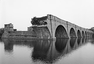
Schoharie Crossing State Historic Site, also known as Erie Canal National Historic Landmark, is a historic district that includes the ruins of the Erie Canal aqueduct over Schoharie Creek, and a 3.5-mile (5.6 km) long part of the Erie Canal, in the towns of Glen and Florida within Montgomery County, New York. It was the first part of the old canal to be designated a National Historic Landmark, prior to the designation of the entire New York State Barge Canal as a NHL in 2017.

Elmer S. Dailey, originally known as the Claire B. Follette, is a wooden barge built by William H. Follette in 1915 at Tonawanda, New York, and rebuilt and renamed in 1928 by Brown Drydock on Staten Island, New York. It was used to transport materials from New York, New Jersey and Connecticut. It is the only known surviving Erie Canal boat and is one of a few remaining wooden-hulled canal boats. It sank in 1974 along with the Priscilla Dailey and the Berkshire No. 7 in the harbor of Bridgeport, Connecticut on the west side of the Pequonnock River. It has deteriorated to the point that a salvage operation could result in it breaking apart. It was added to the National Register of Historic Places on December 21, 1978.
To weigh something is to measure its weight.


