The Palatinate, historically also Rhenish Palatinate, is a region in southwestern Germany. It occupies roughly the southernmost quarter of the German federal state of Rhineland-Palatinate (Rheinland-Pfalz), covering an area of 5,451 square kilometres (2,105 sq mi) with about 1.4 million inhabitants. Its residents are known as Palatines.

The Palatinate Forest, sometimes also called the Palatine Forest, is a low-mountain region in southwestern Germany, located in the Palatinate in the state of Rhineland-Palatinate. The forest is a designated nature park covering 1,771 km2 and its highest elevation is the Kalmit.

The North Palatine Uplands, sometimes incorrectly shortened to Palatine Uplands, is a low mountain range and landscape unit in the German state of Rhineland-Palatinate and belongs mainly to the Palatinate region. It is part of the Saar-Nahe Uplands.
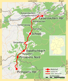
The Biebermühl Railway —sometimes called the Moosalbbahn —is a 35.9 km long railway line from Kaiserslautern to Pirmasens in the German state of Rhineland-Palatinate, which was built between 1875 and 1913. The first section between Biebermühle and Pirmasens connected the city of Pirmasens to the railway network, which could only be achieved via a branch line due to the topography. In 1905, another branch was opened from Biebermühle to Waldfischbach, which was extended in 1913 to Kaiserslautern. It was subsequently used by long-distance services, which operated until 1990. Since then, it has been used only by local services. It is the only one of all the Palatine railway lines that were completed in the 20th century that has never been threatened with closure.
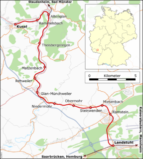
The Landstuhl–Kusel railway is a branch line in the German state of Rhineland-Palatinate, connecting the town of Kusel to the railway network. It was the first line built by the Palatine Northern Railway Company, which was then responsible within the Palatinate for all railway lines to the north of the Mannheim–Saarbrücken railway between Ludwigshafen and Bexbach and the first in the North Palatine Uplands. It was also the only railway in the western part of these uplands that was not threatened with closure at any time. The main purpose of its establishment was the development of the quarries in the area of the Altenglan area, leading to it being sometimes called the Steinbahn.
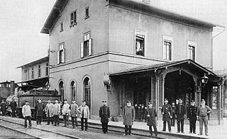
Kusel station is the station of the town of Kusel in the German state of Rhineland-Palatinate. It was opened on 22 September 1868 as the terminus of the Landstuhl–Kusel railway. It is classified by Deutsche Bahn as a category 6 station. The station is located in the network area of the Verkehrsverbund Rhein-Neckar and it is in fare zone 770. The address of the station is Bahnhofstraße 65.

Glan-Münchweiler station is the station of the town of Glan-Münchweiler in the German state of Rhineland-Palatinate. It is classified by Deutsche Bahn as a category 6 station and has two platforms and sidings. The station is located in the network area of the Verkehrsverbund Rhein-Neckar and it is in fare zone 772 and 811. The address of the station is Bahnhofstraße 3.

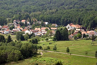
Western Palatinate or West Palatinate is a sub-region in the west of the Palatinate, a German cultural and historic region in the state of Rhineland-Palatinate. It includes the western part of the Palatine Forest, the central part of the North Palatine Uplands, the West Palatine Moor and the Westrich Plateau. Its former name of "Further Palatinate" (Hinterpfalz), which emerged during the time of Bavarian rule in 1816 and was viewed by the local population as very discriminatory, is only commonly used in the Anterior Palatinate (Vorderpfalz).

The Frankenweide is a hill region in the German state of Rhineland-Palatinate. It forms the central part of the Palatine Forest in the Palatinate region.

The Drachenfels is a hill in the northern part of the Palatine Forest in the German state of Rhineland-Palatinate) on the forest estate of the county town of Bad Dürkheim. At 570.8 m above sea level (NHN), it is the highest point of the Palatine Forest north of the Hochspeyerbach - Speyerbach line. The Drachenfels area has been designated as a nature reserve.

Walking routes in the Palatine Forest fall into two categories. The first are longer walking routes, most of which are maintained by the Palatine Forest Club, or PWV, and which are linked to the national and international network of long distance paths. The second category are those local circular walks and themed walking routes, some of which are of wider regional importance, and which are maintained by municipal authorities. The Palatine Forest, as part of the Palatine Forest-North Vosges Biosphere Reserve, is an important conservation area. As a result, the Palatine Forest, the bunter sandstone landscape of the Palatine Forest Nature Park, the castles in the Dahner Felsenland and the cross-border paths into Alsace and the Vosges make the region particularly popular with ramblers and walkers.

The Palatine Ways of St. James are those sections of the Way of St. James in the Palatinate region of Germany and part of the historic pilgrimage route to the northwest Spanish town of Santiago de Compostela. It was there that, according to Christian tradition, the Apostle Saint James the Greater was buried.

The Sickingen Heights form a landscape in the western part of the German state of Rhineland-Palatinate. The region was named after the family of imperial knight, Franz von Sickingen (1481–1523), because most of the area belonged to the territory of the House of Sickingen in the Middle Ages.
The Amseldell is a former park-like leisure area about two kilometres west of the German town of Trippstadt in the Palatine Forest in the state of Rhineland-Palatinate.

Landstuhl station is a station in the town of Landstuhl in the German state of Rhineland-Palatinate. Deutsche Bahn classifies it as belonging to station category 3 and has three platforms tracks. The station is located in the network of the Verkehrsverbund Rhein-Neckar (VRN) and belongs to fare zone 844.

The Gengenbach–Alpirsbach Black Forest Trail is a long distance path through the Central Black Forest in Germany. The 51-kilometre-long east-west route is sponsored and maintained by the Black Forest Club. Its waymark is a blue diamond on a yellow background.
The Landstuhl Marsh or Landstuhl Bog is a region in West Palatinate in the German state of Rhineland-Palatinate.
The Palatine Ridgeway in the North Palatine Uplands of Germany is 112 kilometres long and has seven recommended day stages. It is the third longest Prädikat path in the Palatinate region after the Palatine Wine Trail and Palatine Forest Trail. The long distance path was opened in autumn 2010. One year later, in September 2011, it was given its status as a Prädikat path.