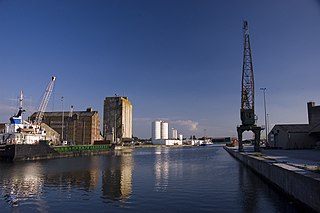
Sharpness is an English port in Gloucestershire, one of the most inland in Britain, and eighth largest in the South West. It is on the River Severn at grid reference SO669027, at a point where the tidal range, though less than at Avonmouth downstream, is still large.
Westerleigh is a clustered village and civil parish in South Gloucestershire, England, it contains sources of the Frome and has an endpoint of the Frome Valley Walkway. It is 0.8 miles (1.3 km) north of the M4, 1 mile (1.6 km) south of Yate and 10 miles (16 km) north-east of the city of Bristol. In the south it includes a steep hill of its own 5 miles (8.0 km) from the crest of the Cotswold hills which is designated an AONB.
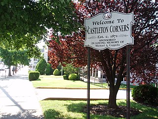
Castleton Corners is an upscale neighborhood of Staten Island, one of the five boroughs of New York City. It is in a region of the island often referred to as the North Shore, Staten Island.
Westerleigh is a residential neighborhood in the northwestern part of Staten Island in New York City.
Willowbrook is a neighborhood in Staten Island, one of the five boroughs of New York City. It is located in the region of the island usually referred to as Mid-Island, immediately to the south of Port Richmond, to the west of Meiers Corners and Westerleigh, to the north of New Springville, and to the east of Bulls Head.

Meiers Corners is a neighborhood on Staten Island, one of the five boroughs of New York City, United States.
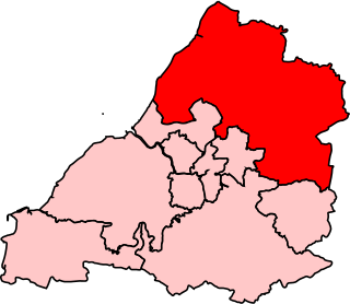
Northavon was, from 1983 until 2010, a constituency represented in the House of Commons of the Parliament of the United Kingdom. It elected one Member of Parliament (MP) by the first past the post system of election.

Nibley is a village in the parish of Westerleigh, South Gloucestershire, England; it is situated about 1.5 miles (2.4 km) west of Yate.
Downend School is a coeducational secondary school and sixth form with academy status, situated on Westerleigh Road in the suburban village of Downend in South Gloucestershire, England.

Yate railway station serves the town of Yate in South Gloucestershire, in south west England. The station is located on the main Bristol to Birmingham line between Bristol Parkway and Cam & Dursley, and is operated by Great Western Railway.
James Aloysius O'Leary was a Democratic member of the United States House of Representatives from New York.
Staten Island Community Board 1 is a local government unit of the city of New York, encompassing the Staten Island neighborhoods of Arlington, northern Castleton Corners, Clifton Concord, Elm Park, Fort Wadsworth, northern Graniteville, Grymes Hill, Livingston, Mariners' Harbor, northern Meiers Corners, New Brighton, Port Ivory, Port Richmond, Randall Manor, Rosebank, Staten Island, St. George, Shore Acres, Silver Lake, Stapleton, Sunnyside, Tompkinsville, West Brighton, Westerleigh, and northern Willowbrook. Community Board 1 is essentially the entire area of Staten Island north of the Staten Island Expressway.
Mayshill or Mays Hill is a hamlet located in the Parish of Westerleigh, South Gloucestershire, England. It is located just off the A432 between Coalpit Heath and Nibley. A small road runs from the hamlet to Frampton End Road, connecting Frampton Cotterell and Iron Acton. Yate and Westerleigh are also nearby. Despite its size the hamlet contains a pub, dating from the 16th Century. The 'New Inn at Mays Hill', on Badminton Road, there is also a house opposite the pub dating from the 17th Century. Mayshill Cemetery, is located across Badminton Road

Henfield is a hamlet in South Gloucestershire, England between Coalpit Heath and Westerleigh, adjoining the hamlet of Ram Hill immediately to the north.

Westerleigh Junction is a railway junction in Gloucestershire, England, where the Cross Country Route (XCR) from York to Bristol Temple Meads meets the South Wales Main Line (SWML) from London Paddington to Swansea, near the village of Westerleigh.

The Church of the Holy Family is a Roman Catholic parish church under the authority of the Roman Catholic Archdiocese of New York, located in Staten Island, New York City. The parish was founded in 1966 and is located at 366 Watchogue Road Westerleigh, Staten Island.
Elizabeth Ann "Betty" Connelly was a politician from Staten Island, New York who represented the North Shore community from 1973 to 2000. She was the first woman to win elective office to any district encompassing Staten Island.

Prohibition Park, also called National Prohibition Park, was a temperance town and park used as a summer colony in the New York City borough of Staten Island, precursor to the modern Westerleigh neighborhood. The park and community were founded after the purchase of the land in 1887 by members of the National Prohibition Party during a temperance movement prior to Federal prohibition in the United States, with the specification that no consumption of alcohol would be permitted in the area. At its peak the park had extended nearly 150 acres, but declined in the 1900s along with the temperance movement, with much of the land sold to non-movement members. The remaining parkland was obtained by the City in 1907, surviving as Westerleigh Park and Northerleigh Park operated by the New York City Parks Department.

Ingram Woods is a 3.7-acre forest preserve in the Westerleigh neighborhood of Staten Island, New York, bound by Warwick Avenue, Purdy Avenue, Ingram Avenue, and Gannon Avenue North. The streets around Ingram Woods Park were laid out in 1907 by the firm of Wood, Harmon & Co. for the planned community of South New York. The properties were offered at the bargain price of $190, but because of the neighborhood’s isolated location, only a few homes were built by the time that the City began laying out the Staten Island Expressway.