See also
| This geology article is a stub. You can help Wikipedia by expanding it. |
| This article about an organisation in the United Kingdom is a stub. You can help Wikipedia by expanding it. |
The Westmorland Geological Society is a body based in the Lake District region of the UK that aims to engage all those interested in geology, particularly in the southern Lakes.
The Society was founded in 1973 and continues to hold a programme of lectures during the winter in Kendal and summer field excursions, looking at the field geology of the Lake District and beyond.
| This geology article is a stub. You can help Wikipedia by expanding it. |
| This article about an organisation in the United Kingdom is a stub. You can help Wikipedia by expanding it. |

Cumbria is a ceremonial and non-metropolitan county in North West England. The county and Cumbria County Council, its local government, came into existence in 1974 after the passage of the Local Government Act 1972. Cumbria's county town is Carlisle, in the north of the county, and the only other major urban area is Barrow-in-Furness on the southwestern tip of the county.
Alfred Wainwright ("A.W.") MBE was a British fellwalker, guidebook author and illustrator. His seven-volume Pictorial Guide to the Lakeland Fells, published between 1955 and 1966 and consisting entirely of reproductions of his manuscript, has become the standard reference work to 214 of the fells of the English Lake District. Among his 40-odd other books is the first guide to the Coast to Coast Walk, a 192-mile long-distance footpath devised by Wainwright which remains popular today.

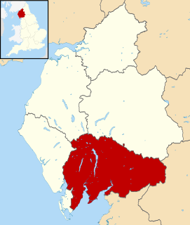
Westmorland is a historic county in north west England. It formed an administrative county between 1889 and 1974, after which the whole county was administered by the new administrative county of Cumbria. In 2013, the Secretary of State for Communities and Local Government, Eric Pickles, formally recognised and acknowledged the continued existence of England's 39 historic counties, including Westmorland.

Windermere is the largest natural lake in England. It is a ribbon lake formed in a glacial trough after the retreat of ice at the start of the current interglacial period. It has been one of the country's most popular places for holidays and summer homes since the arrival of the Kendal and Windermere Railway's branch line in 1847. Historically forming part of the border between Lancashire and Westmorland, it is now within the county of Cumbria and the Lake District National Park.
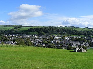
Kendal, once Kirkby in Kendal or Kirkby Kendal, is a market town and civil parish in the South Lakeland District of Cumbria, England. Historically in Westmorland, it lies 8 miles (13 km) south-east of Windermere, 19 miles (31 km) north of Lancaster, 23 miles (37 km) north-east of Barrow-in-Furness and 38 miles (61 km) north-west of Skipton, in the dale of the River Kent, from which comes its name. The 2011 census found a population of 28,586. making it the third largest town in Cumbria after Carlisle and Barrow. It is known today mainly as a centre for tourism, as the home of Kendal mint cake, and as a producer of pipe tobacco and snuff. Its local grey limestone buildings have earned it the nickname "Auld Grey Town".

Appleby-in-Westmorland, a market town and civil parish in the Eden district of Cumbria, England, had a population was 3,048 at the 2011 Census. Traversed by the River Eden, Appleby is the county town of the historic county of Westmorland. It was known simply as Appleby until 1974, when its council, as a successor parish to the former borough, changed its name to preserve the name Westmorland, which had been abolished as a county under the Local Government Act 1972. It lies 13.7 miles south-east of Penrith, 32.2 miles south-east of Carlisle, 27.2 miles north-east of Kendal, 45.2 miles west of Darlington and 61.2 miles west of Middlesbrough.

Windermere is a town and civil parish in the South Lakeland District of Cumbria, England. It has a population of 8,245 increasing to 8,359 at the 2011 Census, and lies about half a mile (1 km) east of the lake, Windermere. Although the town Windermere does not touch the lake, it has now grown together with the older lakeside town of Bowness-on-Windermere, though the two retain distinguishable town centres. Tourism is popular in the town owing to its proximity to the lake and local scenery. Boats from the piers in Bowness sail around the lake, many calling at Ambleside or at Lakeside where there is a restored railway. Windermere Hotel opened at the same time as the railway.
South Lakeland is a local government district in Cumbria, England. The population of the non-metropolitan district at the 2011 Census was 103,658. Its council is based in Kendal. It includes much of the Lake District as well as northwestern parts of the Yorkshire Dales.
Eden is a local government district in Cumbria, England. Its council is based in Penrith. It is named after the River Eden which flows north through the district toward Carlisle.

Beauséjour riding is a federal electoral district in eastern New Brunswick, Canada, which has been represented in the House of Commons of Canada since 1988. It replaced Westmorland—Kent, which was represented from 1968 to 1988.
The Howgill Fells are hills in Northern England between the Lake District and the Yorkshire Dales, lying roughly in between the vertices of a triangle made by the towns of Sedbergh, Kirkby Stephen and Tebay. The name Howgill derives from the Old Norse word haugr meaning a hill or barrow, plus gil meaning a narrow valley.

Westmorland and Lonsdale is a constituency in the south of Cumbria, represented in the House of Commons of the UK Parliament since 2005 by Tim Farron, the former leader of the Liberal Democrats (2015–2017).

A Pictorial Guide to the Lakeland Fells is a series of seven books by A. Wainwright, detailing the fells of the Lake District in northwest England. Written over a period of 13 years from 1952, they consist entirely of reproductions of Wainwright's manuscript, hand-produced in pen and ink with no typeset material.
John Edward Marr FGS FRS was a British geologist. After studying at Lancaster Royal Grammar School, he matriculated to St John's College, Cambridge, graduating with First Class Honours in 1878. Following undergraduate work in the Lake District, he travelled to Bohemia to investigate the fossil collection of Joachim Barrande, where his work won him the Sedgwick Prize in 1882. In 1886, Marr became Lecturer at the University of Cambridge Department of Geology, a position he held for 32 years until he succeeded Thomas McKenny Hughes as Woodwardian Professor of Geology in 1917.
The history of Cumbria as a county of England begins with the Local Government Act 1972. Its territory and constituent parts however have a long history under various other administrative and historic units of governance. Cumbria is an upland, coastal and rural area, with a history of invasions, migration and settlement, as well as battles and skirmishes between the English and the Scots.

Lacy's Caves are a series of 5 chambers in the red sandstone cliff of River Eden, just north of Little Salkeld, Cumbria, England, near Nunnery, at grid reference NY564383.

Stainmore is a remote geographic area in the Pennines on the border of Cumbria, County Durham and North Yorkshire. The name is used for a civil parish in the Eden District of Cumbria, England, including the villages of North Stainmore and South Stainmore. The parish had a population of 253 in the 2001 census, increasing to 264 at the Census 2011. Stainmore Forest stretches further east into County Durham, towards Bowes.
Edmund Johnston Garwood was a British geologist and President of the Geological Society of London from 1930 to 1932.
The Westmorland County Agricultural Society is a registered charity which supports agriculture and related activities in and around the former county of Westmorland, England. Its activities include the annual Westmorland County Show. It was previously known as the Westmorland and Kendal District Agricultural Society.

Kentrigg is a northern suburb of Kendal, Cumbria, England. By road, Kentrigg is located 1.2 miles (1.9 km) north of the centre of Kendal and 1.4 miles (2.3 km) southeast of Burneside. It contains the Carus Green Golf Club, which separates it from Burneside just to the northwest. Across the River Kent to the east is the Shap Road Industrial Estate, north of the district of Mintsfeet and the Mintsfeet Industrial Estate which marks the southeastern side of Kentrigg.