
Waukon is a city in Makee Township,
Allamakee County, Iowa, United States, and the county seat of Allamakee County. The population was 3,897 at the 2010 census. It is home to the annual Allamakee County Fair.
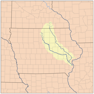
The Cedar River is a 338-mile-long (544 km) river in Minnesota and Iowa. It is a tributary of the Iowa River, which flows to the Mississippi River. The Cedar River takes its name from the red cedar trees growing there, and was originally called the Red Cedar River by the Meskwaki. The first Mississippi steamboat reached Cedar Rapids, Iowa in 1844, and during the next decade, the Red Cedar was an important commercial waterway. The surrounding region is known officially as the Cedar River Valley, though it is more commonly referred to simply as the Cedar Valley.

Pine River may refer to any of the following streams in the U.S. state of Michigan:
- Pine River. The main branch forms with the confluence of the East and West Branches of the Pine River at 44°29′38″N 83°23′16″W in Alcona County. The South Branch joins approximately 1.5 miles (2.4 km) to the south and flows into Iosco County, where it empties into Van Etten Lake at 44°29′38″N 83°23′16″W northwest of Oscoda.
- Pine River. The main branch is formed by the confluence of the North and Middle Branches northeast of Standish and flows into the Saginaw Bay of Lake Huron at 43°58′32″N 83°51′16″W. The South Branch Pine River joins the main stream at 43°59′08″N 83°53′17″W.
- Pine River is a short waterway, which along with Round Lake, connects Lake Charlevoix with Lake Michigan at Charlevoix.
- Pine River rises in Chippewa County and flows south through Mackinac County into the St. Martin Bay of Lake Huron at 46°03′09″N 84°39′22″W The North Pine River, also known as the North Branch Pine River, joins at 46°12′20″N 84°36′17″W. Another tributary, Hemlock Creek, is also known as Pine River.
- Pine River, also known as the South Branch Manistee River, rises in southeast Wexford County, flows southwest across northwest Osceola County, then west and north through the northeast corner of Lake County and back into southwest Wexford County, emptying into the Tippy Dam Pond on the Manistee River at 44°13′37″N 85°54′27″W. The main stream is formed from the confluence of the East Branch Pine River with the North Branch Pine River at 44°06′02″N 85°31′40″W. Another tributary, the Spaulding Creek, is also known as the Little Pine River
- Pine River, in Marquette County, is a very short stream draining Pine Lake into Lake Superior at 46°53′27″N 87°52′13″W, north of the Huron Mountains.
- Pine River rises in from Pine Lake in eastern Mecosta County, flows mostly south and east through Isabella County, then south along eastern edge of Montcalm County, then east and north through Gratiot County and Midland County, emptying into the Chippewa River at 43°36′06″N 84°17′33″W, just about two miles before it joins the Tittabawassee River near Midland. The South Branch Pine River joins the main stream at 43°30′37″N 85°00′02″W Another tributary, Miller Creek, is also sometimes known as Pine River or the West Branch Pine River. The North Branch Pine River joins the main stream at 43°26′03″N 84°50′18″W.
- Pine River empties into the St. Clair River at 42°49′13″N 82°29′08″W on the south side of St. Clair. The South Branch Pine River joins the main stream at 42°58′11″N 82°37′10″W. Another tributary, Quakenbush Drain, is also sometimes known as Pine River.
- Pine Creek empties into Lake Superior and is also known as the Pine River.

The Chippewa River is a stream in the U.S. state of Michigan that runs 91.8 miles (147.7 km) through the central Lower Peninsula. The Chippewa is a tributary of the Tittabawassee River and is thus part of the Saginaw River drainage basin. The river is named after the Chippewa people.

Paint Creek is a direct tributary of the Upper Mississippi River, rising in central Allamakee County, Iowa, in and about the city of Waukon. The catchment measures approximately 85.5 square miles (221 km2). It has some still-rural stretches past 9th Street Southwest in Waukon, but most of the actual Waukon portions have been culverted. It joins the Mississippi approximately 6 miles (9.7 km) above Marquette, Iowa in Pool 10, near river mile 641.

Jacks Fork is one of two rivers in Missouri that are part of the Ozark National Scenic Riverways system.
Clear Creek is a minor tributary of the Upper Mississippi River entirely contained within Allamakee County, Iowa. It enters the Mississippi into Navigation Pool 9 through the city of Lansing, Iowa. Iowa Highway 9 runs through its canyon. It has been restored as fishing stream for brown trout. The stream gives its name to Clear Creek Park in Lansing.
Bear Creek, also known as Bear Hollow Creek,
is a 6.3-mile-long (10.1 km) tributary of the Yellow River of Iowa, originating in Jefferson Township, near Rossville in Allamakee County. It parallels Allamakee County Road X26. It enters the Yellow River near Volney, approximately where the state of Iowa maintains the Yellow River Valley Canoe and Heritage Trail in Allamakee County.
The Trout River is a 13.5-mile-long (21.7 km) tributary of the Upper Iowa River in northeastern Iowa. It rises in Frankville Township in Winneshiek County, south of Iowa Highway 9, and flows north to join the Upper Iowa River in Glenwood Township, east of Decorah. It is joined from the west by a major tributary, Trout Creek. The river and creek should not be confused with another Trout Creek which flow into the Upper Iowa River 5 miles (8 km) to the west at Decorah.
Spook Cave is a flooded cave located about seven miles (11 km) west of McGregor in rural Clayton County, Iowa. It is privately owned and operated as a tourist attraction offering escorted boat rides into the cave. The cave was first discovered in 1953 and opened for business in 1955.
Lime Creek is a 19.8-mile-long (31.9 km) tributary of the Winnebago River in Minnesota and Iowa. Via the Winnebago, Shell Rock, Cedar, and Iowa rivers, it is part of the Mississippi River watershed.
French Creek is a 9.6-mile-long (15.4 km) northward-flowing tributary of the Upper Iowa River, near the latter's confluence with the Mississippi River. It is located in French Creek Township, Allamakee County, Iowa.
Canoe Township is a township in Winneshiek County, Iowa, USA.
Clear Creek is a stream in Johnson and Iowa counties, Iowa, in the United States. It is a tributary of Iowa River.
Otter Creek is a stream in Louisa County, Iowa, in the United States. It is a tributary of the Iowa River.
Indian Creek is a stream in Louisa and Muscatine counties, Iowa, in the United States. It is a tributary of the Iowa River.
Turkey Creek is a stream in Johnson County, Iowa, in the United States.
Patterson Creek is a stream in Allamakee County, Iowa, in the United States.
Coon Creek is a stream in Faribault County, Minnesota and Kossuth County, Iowa. It is a tributary of the Blue Earth River.
Dumas Creek is a stream in Clark County, Missouri. It is a tributary on the west side of the Des Moines River and Lee County, Iowa lies across the river.


