
Baffin Bay, located between Baffin Island and the west coast of Greenland, is a marginal sea of the North Atlantic Ocean. It is connected to the Atlantic via Davis Strait and the Labrador Sea. The narrower Nares Strait connects Baffin Bay with the Arctic Ocean. The bay is not navigable most of the year because of the ice cover and high density of floating ice and icebergs in the open areas. However, a polynya of about 80,000 km2 (31,000 sq mi), known as the North Water, opens in summer on the north near Smith Sound. Most of the aquatic life of the bay is concentrated near that region.

Komsomolets Island is the northernmost island of the Severnaya Zemlya group in the Russian Arctic, and the third largest island in the group. It is the 82nd largest island on earth. About 65% of the island is covered with glaciers.
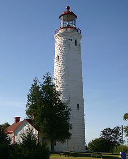
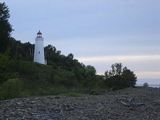
The Imperial Towers of Ontario were six of the earliest lighthouses built on Lake Huron and Georgian Bay, all constructed primarily of stone, by the Province of Canada. The origin of the designation Imperial is not certain, but some historians speculate that because the towers were public construction built under the colonial administration while Canada was a self-governing colony of Britain, the name would assure at least some funding from the British Empire's Board of Trade.
Pleasant Bay is a bay in Washington County, Maine, at the mouth of the Pleasant River.
Harrington Bay is a bay in Washington County, Maine.
Narraguagus Bay is a bay in Washington County, Maine.
Englishman Bay is a bay in Washington County, Maine.
Chandler Bay is a bay in Jonesport, Maine.
Frenchman Bay is a bay in Hancock County, Maine, named for Samuel de Champlain, the French explorer who visited the area in 1604.

Hope Island is the northern of three islands in south eastern Georgian Bay, of Lake Huron, in the Canadian province of Ontario. It has an elevation of 187 meters above sea level and is currently uninhabited and not presently slated for development. It was named by Henry Bayfield after he surveyed it in the 19th century. Like its neighbours, Beckwith Island and Christian Island, the uninhabited island is part of the Beausoleil First Nation.
The Little River is a 7.3 mile long river in the towns of Kingston and Brentwood in Rockingham County, New Hampshire, in the United States. It is a tributary of the Exeter River, part of the Great Bay/Piscataqua River watershed in the New Hampshire Seacoast region. The river should not be confused with the Little River of Exeter, New Hampshire, another tributary of the Exeter River less than three miles away.

Palm Island is a neighborhood of South Beach in the city of Miami Beach on a man-made island in Biscayne Bay, Florida, United States. just south of Hibiscus Island. It is a residential neighborhood with relatively high property values, solely accessible by land via the MacArthur Causeway. The entire island has an area of 82 acres.

Giants Tomb Island is an island with no permanent residents located in Southern Georgian Bay in Ontario, Canada. It measures approximately 5 kilometres from north to south and 2 kilometres from east to west.
The Rubicon Keys are two small islands north of the upper Florida Keys in Biscayne National Park. They are in Miami-Dade County, Florida.
Floridana Beach is an unincorporated community in Brevard County, Florida, United States. It is located on a barrier island southeast of the city of Melbourne and east of the town of Grant-Valkaria. It is just south of the unincorporated community of Melbourne Shores, and north of the unincorporated community of Sunnyland Beach.
Griffith Island is an island in Georgian Bay, in the province of Ontario, Canada. It is one of three islands in Colpoys Bay, and sits to the north east of Wiarton and north of Owen Sound. The other two islands in Colpoy's Bay are White Cloud Island and Hay Island. From the early 1970s, the island has been owned by and in private use of the Griffith Island Club, principally for recreational shooting and hunting. Hence, it is strictly off limits to the general public.
Hay Island is an island in Georgian Bay, in the province of Ontario, Canada. It is one of three islands in Colpoys Bay, and sits to the north east of Wiarton and north of Owen Sound. The other two islands in Colpoys Bay are White Cloud Island and Griffith Island. It is known as Hay Island because of the abundance of hay grown dating back from 1856. British troops grew hay over long winters on this Island.

Nautilus Island is a privately owned island in Penobscot Bay, Maine. It is part of the Town of Brooksville, in Hancock County.
Blue Hill Bay is a bay lying to the west of Mount Desert Island in Hancock County, Maine. Approximately 14 mi (23 km) long, its southern boundaries are set by Swan's Island and Placentia Island at its entrance; the town of Blue Hill lies at the far end. Morgan Bay, Union River Bay, and Western Bay empty into it. Long Island in the north of the bay is the largest uninhabited island in Maine.
Wohoa Bay is a bay on the coast of Washington County, Maine. It is located between the towns of Addison and Jonesport. It features a coastal plateau bog ecosystem not found anywhere else in North America. Three rare species have been found in Wohoa Bay, including the crowberry, blue butterfly and bald eagle. Both West River and Indian River drain into Wohoa Bay.


