
Hampden County is a non-governmental county located in the Pioneer Valley of the state of Massachusetts, in the United States. As of the 2010 census, Hampden County's population was 463,490. As of 2018, Hampden County's estimated population was 470,406. Its traditional county seat is Springfield, the Connecticut River Valley's largest city, and economic and cultural capital; with an estimated population of 154,758, approximately 1 in 3 residents of Hampden County live in Springfield. Hampden County was split from Hampshire County in 1812, because Northampton, Massachusetts, was made Hampshire County's "shire town" in 1794; however, Springfield—theretofore Hampshire County's traditional shire town, dating back to its founding in 1636—grew at a pace far quicker than Northampton and was granted shire town-status over its own, southerly jurisdiction. It was named for John Hampden. To the north of Hampden County is modern-day Hampshire County; to the west is Berkshire County; to the east is Worcester County; to the south are Litchfield County, Hartford County, and Tolland County in Connecticut.

Rowe is a town in Franklin County, Massachusetts, United States. The population was 393 at the 2010 census. It is part of the Springfield, Massachusetts Metropolitan Statistical Area.

Hatfield is a census-designated place (CDP) comprising the main village in the town of Hatfield in Hampshire County, Massachusetts, United States. The population of the CDP was 1,318 at the 2010 census, out of a total town population of 3,279. It is part of the Springfield, Massachusetts Metropolitan Statistical Area.

The Governor Edmund G. Brown California Aqueduct is a system of canals, tunnels, and pipelines that conveys water collected from the Sierra Nevada Mountains and valleys of Northern and Central California to Southern California. Named after California Governor Edmund Gerald "Pat" Brown Sr., the over 400-mile (640 km) aqueduct is the principal feature of the California State Water Project.
Deerfield River is a river that runs for 76 miles (122 km) from southern Vermont through northwestern Massachusetts to the Connecticut River. The Deerfield was historically influential in the settlement of western Franklin County, Massachusetts, and its namesake town. The Deerfield River is the Connecticut River's second longest tributary in Massachusetts, 2.1 miles (3.4 km) shorter than the Metropolitan Springfield's Westfield River.
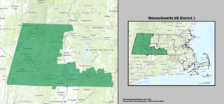
Massachusetts's 1st congressional district is located in western and central Massachusetts. The largest Massachusetts district in area, it covers about one-third of the state and is more rural than the rest. It has the state's highest point, Mount Greylock. The district includes the cities of Springfield, West Springfield, Pittsfield, Holyoke, and Westfield.

Tarbell Brook is a 10.1-mile-long (16.3 km) stream located in southwestern New Hampshire and northern Massachusetts in the United States. It is a tributary of the Millers River, itself a tributary of the Connecticut River, which flows to Long Island Sound.

The Ware River Diversion is a dam on the Ware River. It is part of the Boston, Massachusetts public water supply system, maintained by the Massachusetts Water Resources Authority (MWRA). It is located in Worcester County in the town of Barre, close to its border with Oakham.
Bear Swamp Generating Station or Jack Cockwell Station is a pumped-storage hydroelectric underground power station that straddles the Deerfield River in Rowe and Florida, Massachusetts. It is one of many hydroelectric facilities along the river, giving that waterway the nickname of "the hardest working river in the county".

The Cochituate Aqueduct was an aqueduct in Massachusetts that brought water to Boston from 1848 to 1951.
The Broad Brook Canal is a water-supply canal feeding the Springfield Reservoir in Ludlow, Massachusetts, a public water supply for the city of Springfield, Massachusetts. Its northern segment is also known as the Jabish Canal.

The Sudbury Dam Historic District is a historic district on the southeastern end of Sudbury Reservoir off MA 30 in Framingham and Southborough, Massachusetts. The district encompasses the Sudbury Dam, which impounds the reservoir, and an area encompassing several historic structures located below the dam. The area includes water-supply-related structures from three phases of development of the Greater Boston water supply system. It was listed on the National Register of Historic Places in 1990.
East Forest Park is a neighborhood in the south central part of Springfield, Massachusetts. The neighborhood borders East Longmeadow, Forest Park, and the Sixteen Acres neighborhood.
Watershops Pond is a lake in the city of Springfield, Massachusetts. Located in the Upper Hill neighborhood, it is the city's second-largest body of water, after the Connecticut River. Watershops Pond features 7 miles of shorelines and 186 acres. It is a major site for fishing, featuring species ranging from Black Crappie, Bluegill, Brown Trout, Chain Pickerel, Channel Catfish, Common Carp, Largemouth Bass, Pumpkinseed, Rainbow Trout, and Yellow Bass. The pond was formed by damming the Mill River, which flows out of the westernmost end and continues 1.25 miles until its confluence with the Connecticut River.
The Mill River is a 1.25-mile (2.01 km) long tributary of the Connecticut River in Springfield, Massachusetts. It flows from Watershops Pond to its confluence with the Connecticut River. It is referred to as "The Miracle Mile" in a 2009 master's thesis that outlines possibilities for reclaiming the river's mouth as a recreational area. As of 2011, the final 350 feet (110 m) of the river, including its mouth, is confined in a pipe underneath Interstate 91, railroad tracks and a car dealership. Many Springfield residents bemoan the loss of the Mill River as a recreational area, and hope to gain greater access to both it and Connecticut Rivers in upcoming years. As it has for over a century, today the Mill River serves as a barrier between Springfield neighborhoods. Surrounding it are some of the most densely urbanized locations in Springfield.

The Angeles Tunnel is a 7.2-mile-long (11.6 km), 30-foot-diameter (9.1 m) water tunnel located in the Sierra Pelona Mountains in Los Angeles County, California, about 50 miles (80 km) north of Los Angeles. It was constructed between 1967 and 1970 as part of the California State Water Project and serves as the final leg of the west branch of the California Aqueduct, which carries Northern California water to Southern California residents.
Northfield Mountain is a pumped-storage hydroelectric plant and reservoir located on and under the similarly named Northfield Mountain in Erving and Northfield, Massachusetts. It is currently owned by FirstLight Power Resources, which purchased the facility from Northeast Utilities in 2006.

The Royston River, an inland perennial river of the Goulburn Broken catchment, part of the Murray-Darling basin, is located in the lower South Eastern Highlands bioregion and Northern Country/North Central regions of the Australian state of Victoria. The headwaters of the Royston River rise on the western slopes of the Victorian Alps and descend to flow into the Rubicon River.


