See also
| | This disambiguation page lists articles associated with the title Wilton Park. If an internal link led you here, you may wish to change the link to point directly to the intended article. |
Wilton Park may refer to:
| | This disambiguation page lists articles associated with the title Wilton Park. If an internal link led you here, you may wish to change the link to point directly to the intended article. |
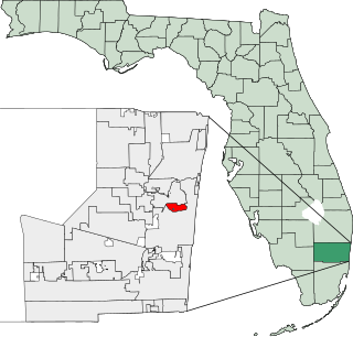
Wilton Manors is a city in Broward County, Florida, United States. As of the 2010 census, the city had a population of 11,632. Wilton Manors is part of the Fort Lauderdale area, which was home to 5,564,635 people at the 2010 census.

Wilton House is an English country house at Wilton near Salisbury in Wiltshire, which has been the country seat of the Earls of Pembroke for over 400 years.

The borough of Redcar and Cleveland is a unitary authority area in the North East of England, within the ceremonial county of North Yorkshire. The main settlements are Redcar, Saltburn-by-the-Sea, Guisborough, and towns and villages of Brotton, Eston, Grangetown, South Bank, Kirkleatham, Loftus and Skelton. It had a resident population of 135,200 in 2011.

Burning Mountain, the common name for Mount Wingen, is a hill near Wingen, New South Wales, Australia, approximately 224 km (139 mi) north of Sydney just off the New England Highway. It takes its name from a smouldering coal seam running underground through the sandstone. Burning Mountain is contained within the Burning Mountain Nature Reserve, which is administered by the NSW National Parks and Wildlife Service (NPWS).

Heaton Park is a municipal park in Manchester, England, covering an area of over 600 acres (242.8 ha). The park includes the grounds of a Grade I listed, neoclassical 18th century country house, Heaton Hall. The hall, remodelled by James Wyatt in 1772, is now only open to the public on an occasional basis as a museum and events venue.

Margam Country Park is a country park estate in Wales, of around 850 acres (3.4 km²). It is situated in Margam, about 2 miles (3 km) from Port Talbot in south Wales. It was once owned by the Mansel Talbot family and is now owned and administered by the local council, Neath Port Talbot County Borough Council. Situated within the park are three notable buildings: Margam Abbey, a Cistercian monastery; Margam Castle, a neo-Gothic country house that was once the seat of the Mansel Talbot family; and the 18th-century Orangery.

Tingha is a small town on the Northern Tablelands, New South Wales, Australia in Inverell Shire. Formerly part of Armidale Region, on 1 July 2019, responsibility for Tingha was transferred from Armidale Regional Council to Inverell Shire Council. The town is 30 kilometres (19 mi) south of Inverell and 629 kilometres (391 mi) north-north-east of Sydney. Tingha is an Aboriginal word for "flat or level".
The New South Wales Office of Environment and Heritage (OEH), a former division of the Government of New South Wales between April 2011 and July 2019, was responsible for the care and protection of the environment and heritage, which includes the natural environment, Aboriginal country, culture and heritage, and built heritage in New South Wales, Australia. Until its abolition in 2019, the OEH supported the community, business and government in protecting, strengthening and making the most of a healthy environment and economy within the state. The OEH was part of the Department of Planning and Environment cluster and managed national parks and reserves.

Macarthur is a region in the south-west of Sydney, in the state of New South Wales, Australia. The region includes the local government areas of the City of Campbelltown, Camden Council and Wollondilly Shire. It covers an area of 3,067 square kilometres and has a population of close to 310,000 residents. The region geographically forms the foothills between the Blue Mountains and Southern Highlands regions.
Griffithstown is a large community of Pontypool in the borough of Torfaen, Wales, within the historic boundaries of Monmouthshire. It is an ecclesiastical parish, formed in May 1898, from Llanfrechfa Upper and Panteg, and includes Sebastopol, but, under the provisions of the Local Government Act 1894, became a separate civil parish.

Wollondilly Shire is a periurban local government area adjacent to the south-western fringe of Sydney, parts of which fall into the Macarthur, Blue Mountains and Central Tablelands regions in the state of New South Wales, Australia. Wollondilly Shire was created by proclamation in the NSW Government Gazette on 7 March 1906, following the passing of the Local Government (Shires) Act 1905, and amalgamated with the Municipality of Picton on 1 May 1940.

Wollondilly is an electoral district of the Legislative Assembly in the Australian state of New South Wales. It is represented by Nathaniel Smith of the Liberal Party.
The Avon River, a perennial river of the Hawkesbury-Nepean catchment, is located in the Southern Highlands and Macarthur districts of New South Wales, Australia.
The Cordeaux River, a perennial river of the Hawkesbury-Nepean catchment, is located in the Southern Highlands and Macarthur regions of New South Wales, Australia.
Wilton North railway station is a former railway station in Wilton, Wiltshire, UK, in the Wylye Valley. Opened with the line on 30 June 1856, the station for Wilton was originally just one platform on the left of trains heading towards Westbury. A second platform was added when the line was doubled in 1896. Along with other local stations, it was closed on 19 September 1955, although Wilton South remained open for passengers until 1966. Wilton North remained open for goods traffic until 6 September 1965 and the goods shed remains intact and used as a shop.

Wilton is a small town of the Macarthur Region of New South Wales, Australia in the Wollondilly Shire. The town is located around 80 km south west of Sydney CBD. It is home to a population of 3080 and includes the new estate of Bingara Gorge. It is located within close proximity of Cataract Dam. Furthermore, the town is just located off Picton Road which diverges off the Hume Highway to Wollongong. Wilton has a take away, which includes pizza, and opposite thereof is a Shell service station. The Bingara Gorge development includes a Domino's pizza shop, an IGA store, a medical centre & pharmacy, a liquor store, 2 cafes and a Chinese restaurant.

Netherhampton is a village and civil parish in Wiltshire, England, immediately west of the city of Salisbury. The village is about 2 miles (3.2 km) from the city centre.
Procambridgea is a genus of South Pacific sheetweb spiders that was first described by Raymond Robert Forster & C. L. Wilton in 1973.

Wilton Park is a heritage-listed farm located at Wilton Park Road in the south-western Sydney settlement of Wilton in the Wollondilly Shire local government area of New South Wales, Australia. It was possibly designed by Albert Bond and built in 1892. It was added to the New South Wales State Heritage Register on 2 April 1999.