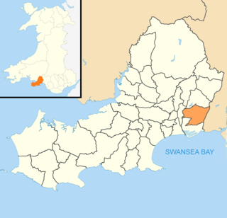
Winch Wen (Welsh : Winsh-wen, meaning "white well") is a suburban district in the Bon-y-maen ward of the City and County of Swansea, Wales. It lies some 3.5 miles (5 km) north-east of Swansea city centre.

Welsh or y Gymraeg is a member of the Brittonic branch of the Celtic languages. It is spoken natively in Wales, by some in England, and in Y Wladfa. Historically, it has also been known in English as "Cambrian", "Cambric" and "Cymric".

Bon-y-maen, sometimes spelt Bonymaen, is a community in Swansea, Wales located about 1.5 miles (2.4 km) north east of Swansea city centre. It falls within the coterminous Bonymaen ward for elections to Swansea Council.

Swansea, is a coastal city and county, officially known as the City and County of Swansea in Wales. Swansea lies within the historic county boundaries of Glamorgan and the ancient Welsh commote of Gŵyr on the southwest coast. The county area includes Swansea Bay and the Gower Peninsula. Swansea is the second largest city in Wales and the twenty-fifth largest city in the United Kingdom. According to its local council, the City and County of Swansea had a population of 241,300 in 2014. The last official census stated that the city, metropolitan and urban areas combined concluded to be a total of 462,000 in 2011; the second most populous local authority area in Wales after Cardiff.
The district consists principally of residential housing situated to the south of Carmel Road, although it also includes an industrial estate - lying a little further north, and also known simply as Winch Wen - which is home to a number of small factories and warehouses.

An industrial park is an area zoned and planned for the purpose of industrial development. An industrial park can be thought of as a more "heavyweight" version of a business park or office park, which has offices and light industry, rather than heavy industry.
To the immediate east of Winch Wen lies Pentre Dwr, a predominantly farming and rural area.
Pentre Dwr is a village in the City and County of Swansea, Wales falling within the Bon-y-maen ward. The village approximates to the settlement east of Winch Wen and south of Trallwn along Crymlyn Road.
Coordinates: 51°38′56.00″N3°53′51.00″W / 51.6488889°N 3.8975000°W

A geographic coordinate system is a coordinate system that enables every location on Earth to be specified by a set of numbers, letters or symbols. The coordinates are often chosen such that one of the numbers represents a vertical position and two or three of the numbers represent a horizontal position; alternatively, a geographic position may be expressed in a combined three-dimensional Cartesian vector. A common choice of coordinates is latitude, longitude and elevation. To specify a location on a plane requires a map projection.