In Gaelic myth, the Cailleach is a divine hag and ancestor, associated with the creation of the landscape and with the weather, especially storms and winter. The word literally means 'old woman, hag', and is found with this meaning in modern Irish and Scottish Gaelic, and has been applied to numerous mythological and folkloric figures in Ireland, Scotland, and the Isle of Man. In modern Irish folklore studies, she is sometimes known as The Hag of Beara, while in Scotland she is known as Beira, Queen of Winter.

Dufftown is a burgh in Moray, Scotland. While the town is part of the historic Mortlach parish, the town was established and laid out in the early 19th century as part of a planned new town settlement. The town has several listed 19th century buildings and serves as a regional centre for agriculture, tourism and services. The town is well known for its whisky based economy, as it produces more whisky than any other town in Scotland and is home to several existing and former distilleries.

Fauldhouse is a village in West Lothian, Scotland. It is about halfway between Glasgow and Edinburgh. The nearest towns to Fauldhouse are Whitburn and Livingston. Other neighbouring villages include Longridge, Shotts and Stoneyburn. At approximately 750 feet above sea level, Fauldhouse is one of the highest villages in West Lothian.
Ratho is a village in the rural west part of the City of Edinburgh council area, Scotland. Its population at the 2011 census was 1,634 based on the 2010 definition of the locality. It was formerly in the old county of Midlothian. Ratho Station, Newbridge and Kirkliston are other villages in the area. The Union Canal passes through Ratho. Edinburgh Airport is situated only 4 miles (7 km) away. The village has a high ratio of its older houses built from whin stone due to a whin quarry nearby. The older, historical, part of the village was designated a Conservation Area in 1971 by Midlothian County Council.

Ardvreck Castle is a castle, now ruinous, standing on a rocky promontory in Loch Assynt, Sutherland, Scotland, UK. The structure dates from about 1490 and is associated with the then landowners, the Macleods of Assynt.

Linlithgow is a town in West Lothian, Scotland. It was historically West Lothian's county town, reflected in the county's historical name of Linlithgowshire. An ancient town, it lies in the Central Belt on a historic route between Edinburgh and Falkirk beside Linlithgow Loch. The town is situated approximately 20 miles (32 km) west of Edinburgh.
Carlin Stone or Carline Stane is the name given to a number of prehistoric standing stones and natural stone or landscape features in Scotland. The significance of the name is unclear, other than its association with old hags, witches, and the legends of the Cailleach.
Stoneykirk is an area and a village in the heart of the Rhins of Galloway, Wigtownshire, in the administrative council area of Dumfries and Galloway, Scotland nearly 10 miles (16 km) in length and 3+1⁄2 miles (5.6 km) in breadth, bounded on the east by the bay of Luce, and on the west by the Irish Channel, 5 miles (8 km) south of Stranraer.

Brahan Castle was situated 3.5 miles (5.6 km) south-west of Dingwall, in Easter Ross, Highland Scotland. The castle belonged to the Earls of Seaforth, chiefs of the Clan Mackenzie, who dominated the area.

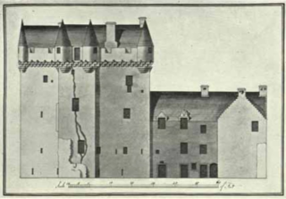
Redcastle, historically known as Edirdovar and Ederdour, is a medieval castle in Killearnan on the Black Isle, northern Scotland. It is so named from the colour of the stone of which it is built. The castle is now in a state of ruinous disrepair, although it is protected as a category B listed building.
Dairsie Castle is a restored tower house located 1.3 kilometres (0.81 mi) south of Dairsie in north-east Fife, Scotland. The castle overlooks the River Eden.

The Battle of Summerdale was fought on 19 May 1529, and was the last battle to take place on Orkney soil. The battle took place on the boundary of the parishes of Orphir and Stenness in Mainland, Orkney. The battle was fought between the Sinclairs of Orkney and Shetland and the Sinclairs of Caithness, who had the support of James V, King of Scotland.
Events from the year 1754 in Scotland.
Cromarty Castle was a castle in Cromarty, Scotland. Cromarty, then known as Crumbathyn, was created a royal burgh in the reign of King Alexander I of Scotland. Cromarty overlooks the entrance to the Cromarty Firth and was strategically important. A motte-and-bailey castle was built in the 12th–13th century. The castle was held by Sir William de Monte Alto during the Scottish wars of independence for both the English and the Scottish.
Craigie is a small village and parish of 6,579 acres in the old district of Kyle, now South Ayrshire, four miles south of Kilmarnock, Scotland. This is mainly a farming district, lacking in woodland, with a low population density, and only one village. In the 19th century, high quality lime was quarried here with at least three sites in use in 1832.
Kirk of Calder is a medieval church in Mid Calder, West Lothian. It is listed as a Category A building by Historic Environment Scotland. The church is of Ashlar stone in a Gothic style. The present Kirk dates from 1541 but was built on the site of an earlier 12th century church.
William Macdonald Mackenzie was a Scottish architect, prominent in the first half of the 19th century. He designed several notable buildings in Scotland, mostly manses and church buildings.

St Martins is a parish in Perth and Kinross, Scotland, just north of the Sidlaws range of hills, about 4.3 miles (6.9 km) north-northeast of Perth and 1.2 miles (1.9 km) northwest of Balbeggie. The parish is named for Martin of Tours, of Lower Hungary.