
The Clark Fork, or the Clark Fork of the Columbia River, is a river in the U.S. states of Montana and Idaho, approximately 310 miles (500 km) long. The largest river by volume in Montana, it drains an extensive region of the Rocky Mountains in western Montana and northern Idaho in the watershed of the Columbia River. The river flows northwest through a long valley at the base of the Cabinet Mountains and empties into Lake Pend Oreille in the Idaho Panhandle. The Pend Oreille River in Idaho, Washington, and British Columbia, Canada which drains the lake to the Columbia in Washington, is sometimes included as part of the Clark Fork, giving it a total length of 479 miles (771 km), with a drainage area of 25,820 square miles (66,900 km2). In its upper 20 miles (32 km) in Montana near Butte, it is known as Silver Bow Creek. Interstate 90 follows much of the upper course of the river from Butte to northwest of Missoula. The highest point within the river's watershed is Mount Evans at 10,641 feet (3,243 m) in Deer Lodge County, Montana along the Continental Divide.

Hazel Dell is an unincorporated area and census-designated place (CDP) in Clark County, Washington, United States, located north and west of Vancouver. As of the 2010 census the population was 19,435. Previous censuses divided the community into two areas, Hazel Dell North and Hazel Dell South.

Alameda Creek, originally Arroyo de la Alameda, is a large perennial stream in the San Francisco Bay Area. The creek runs for 45 miles (72 km) from a lake northeast of Packard Ridge to the eastern shore of San Francisco Bay by way of Niles Canyon and a flood control channel.

Deer Creek is a 60-mile-long (97 km) southwestward-flowing stream in Northern California that flows through Tehama County, California. It is an eastside tributary of the Sacramento River. As one of only three remaining Sacramento River tributaries supporting native runs of the genetically distinct Central Valley spring-run Chinook salmon, it is a stronghold for this state and federally endangered fish as well as other salmonids.

In urban design and urban planning, daylighting is the redirection of a stream into an above-ground channel. Typically, the rationale behind daylighting is to revert a stream of water to a more natural state, for the purposes of runoff reduction, habitat creation for species in need of it, or for aesthetic purposes. Daylighting is intended to revitalize the riparian environment for a stream which had been previously diverted into a culvert, pipe, or a drainage system. In the UK, the practice is also known as deculverting.
Pilarcitos Creek is a 13.5-mile-long (21.7 km) coastal stream in San Mateo County, California, United States, that rises on the western slopes of the Santa Cruz Mountains and descends through Pilarcitos Canyon to discharge into the Pacific Ocean Half Moon Bay State Beach.

Johnson Creek is a 25-mile (40 km) tributary of the Willamette River in the Portland metropolitan area of the U.S. state of Oregon. Part of the drainage basin of the Columbia River, its catchment consists of 54 square miles (140 km2) of mostly urban land occupied by about 180,000 people as of 2012. Passing through the cities of Gresham, Portland, and Milwaukie, the creek flows generally west from the foothills of the Cascade Range through sediments deposited by glacial floods on a substrate of basalt. Though polluted, it is free-flowing along its main stem and provides habitat for salmon and other migrating fish.

Lacamas Creek is in Clark County, Washington, United States, and flows about 12.5 miles (20.1 km) from headwaters near Camp Bonneville to Lacamas Lake and Round Lake in Camas, and eventually into the Washougal River. Its name is derived from that of the native camas plant. Lacamas Creek is fed by numerous streams, but the five largest tributaries are Matney Creek, Shanghai Creek, Fifth Plain Creek, China Ditch, and Dwyer Creek.
Tryon Creek is a 4.85-mile (7.81 km) tributary of the Willamette River in the U.S. state of Oregon. Part of the drainage basin of the Columbia River, its watershed covers about 6.5 square miles (16.8 km2) in Multnomah and Clackamas counties. The stream flows southeast from the Tualatin Mountains through the Multnomah Village neighborhood of Portland and the Tryon Creek State Natural Area to the Willamette in the city of Lake Oswego. Parks and open spaces cover about 21 percent of the watershed, while single-family homes dominate most of the remainder. The largest of the parks is the state natural area, which straddles the border between the two cities and counties.

Pescadero Creek is a major stream in Santa Cruz and San Mateo counties in California. At 26.6 miles (42.8 km), it is the longest stream in San Mateo County and flows all year from springs in the Santa Cruz Mountains. Its source is at 1,880 feet (570 m) above sea level on the western edge of Castle Rock State Park, with additional headwaters in Portola Redwoods State Park, and its course traverses Pescadero Creek County Park and San Mateo County Memorial Park before entering Pescadero Marsh Natural Preserve at Pescadero State Beach and thence to the Pacific Ocean 14.4 miles (23 km) south of Half Moon Bay.

Mahanoy Creek is a 51.6-mile-long (83.0 km) tributary of the Susquehanna River in Northumberland and Schuylkill counties, Pennsylvania. There are at least 35 sources of acid mine drainage in the creek's watershed. Anthracite was mined in the upper part of the Mahanoy Creek watershed in the 19th and 20th centuries. Mahanoy Creek's tributaries include Schwaben Creek, Zerbe Run, Little Mahanoy Creek, Shenandoah Creek, and North Mahanoy Creek. Little Mahanoy Creek and Schwaben Creek are two streams in the watershed that are unaffected by acid mine drainage. Schwaben Creek has a higher number and diversity of fish species than the main stem.

The Columbia Slough is a narrow waterway, about 19 miles (31 km) long, in the floodplain of the Columbia River in the U.S. state of Oregon. From its source in the Portland suburb of Fairview, the Columbia Slough meanders west through Gresham and Portland to the Willamette River, about 1 mile (1.6 km) from the Willamette's confluence with the Columbia. It is a remnant of the historic wetlands between the mouths of the Sandy River to the east and the Willamette River to the west. Levees surround much of the main slough as well as many side sloughs, detached sloughs, and nearby lakes. Drainage district employees control water flows with pumps and floodgates. Tidal fluctuations cause reverse flow on the lower slough.
SPAWN, the Salmon Protection and Watershed Network, is a project of the Turtle Island Restoration Network (TIRN), a United States 501(c)(3) nonprofit environmental organization.

Northwest Branch Anacostia River is a 21.5-mile-long (34.6 km) free-flowing stream in Montgomery County and Prince George's County, Maryland. It is a tributary of the Anacostia River, which flows to the Potomac River and the Chesapeake Bay.

Battle Creek is a 16.6-mile-long (26.7 km) creek located in Shasta and Tehama counties, California. It is a major tributary to the Sacramento River.
Gee Creek is a 4th order tributary to the Columbia River, a.k.a. small creek, within Clark County, Washington named for William Gee, an early pioneer upon whose land the stream arose from. The Upper Gee Creek watershed, with an 8.7-square-mile (23 km2) drainage basin, is completely located within the Ridgefield quadrangle. The mainstem extends approximately 11.5 miles (18.5 km), of which 4.9 miles (7.9 km) are located within the Upper Gee Creek basin. Originating in the hills along Interstate 5, through Ridgefield, Washington and empties into a series of lakes on the Columbia River Floodplain. Abrams Park in Ridgefield is a local access point for Gee Creek and since 2003, has had a stream flow gauge installed to collect hydrological data. The lowest segment of Gee Creek meanders for 3 miles (4.8 km) through the Ridgefield National Wildlife Refuge.
Burnt Bridge Creek is a 13-mile (21 km) stream flowing for most of its length within the city of Vancouver in the U.S. state of Washington. It begins as drainage from field ditches near the unincorporated community of Orchards, east of the city. The creek flows generally west to Vancouver Lake. The lake drains to Lake River, which empties into the Columbia River about 11 miles (18 km) downstream of the city.

Schwaben Creek is a tributary of Mahanoy Creek in Northumberland County, Pennsylvania, in the United States. Schwaben Creek is approximately 10.7 miles (17.2 km) long. The creek has two named tributaries, which both join Schwaben Creek fairly close to its mouth. The tributaries are called Middle Creek and Mouse Creek. Schwaben Creek flows through Upper Mahanoy Township, Washington Township, and Jackson Township. Nearly all of the creek's watershed is devoted to agricultural land and forests, although there is some development. Painted furniture also was made in the Schwaben Creek valley in the 18th and 19th centuries. The creek is in the ridge-and-valley geographical province.
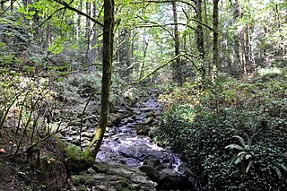
Moxlie Creek is stream in Thurston County in the U.S. state of Washington. It is an Olympian creek originating from artesinal springs in Watershed Park. It flows north into the East Bay of Budd Inlet. The creek is piped underground between East Bay and the headwaters, more than one third of its 1.8 mile length. For over 50 years the park groundwater was used to supply the city's drinking water, and waterworks remnants can be seen in the area.


