This page is based on this
Wikipedia article Text is available under the
CC BY-SA 4.0 license; additional terms may apply.
Images, videos and audio are available under their respective licenses.

The Cocoparra National Park is a protected national park that is located in the Riverina region of New South Wales, in eastern Australia. The 8,357-hectare (20,650-acre) national park is situated 457 kilometres (284 mi) southwest of Sydney and 25 kilometres (16 mi) northeast of Griffith.

The Mitchell River National Park is a national park located in the Gippsland region of Victoria, Australia. The 14,250-hectare (35,200-acre) national park is situated approximately 320 kilometres (200 mi) east of Melbourne via the Princes Highway, and approximately 25 kilometres (16 mi) northwest of Bairnsdale. The northern portion of the park may be accessed via Dargo.

Light Regional Council is a local government area north of Adelaide in South Australia. It is based in the town of Kapunda, and includes the towns of Freeling, Greenock, Hansborough, Hewett, Roseworthy and Wasleys.

The Mitchell River is a perennial river of the East Gippsland catchment, located in the Australian state of Victoria. The unregulated river provides a unique example of riparian ecology, flowing generally south with the catchment area drawing from the steep mountains of the Victorian Alps to enter Lake King, one of the Gippsland Lakes, and then empty into the Bass Strait.

The Clare and Gilbert Valleys Council is a local government area located in the Yorke and Mid North region of South Australia. The council was founded on 1 July 1997 with the amalgamation of the District Council of Clare, the District Council of Riverton and the District Council of Saddleworth and Auburn. The council seat is located at Clare; it also maintains branch offices at Riverton and Saddleworth.
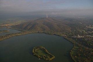
Springbank Island, within Lake Burley Griffin, is located in Canberra, Australian Capital Territory, Australia. The island was named after the rural property that was partly submerged as a result of the creation of the lake and now composes part of the island.
Catherine Bateson is an Australian writer.

The United Shire of Beechworth was a local government area located about 270 kilometres (168 mi) northeast of Melbourne, the state capital of Victoria, Australia. The shire covered an area of 771.57 square kilometres (297.9 sq mi), and existed from 1856 until 1994.

Glencoe is a regional town in South Australia, Australia located approximately 25 km north-west of Mount Gambier. At June 2016, Glencoe had an estimated population of 661.

Mannahill is a settlement on the Barrier Highway and Indian Pacific railway line in South Australia. Mannahill is in the Northeast Pastoral district and is one of the easternmost settlements in South Australia. The population of Mannahill is 66 persons: 42 males and 24 females.
Cordillo Downs or Cordillo Downs Station is both a pastoral lease currently operating as a cattle station and a formal bounded locality in South Australia. It is located about 116 kilometres (72 mi) north of Innamincka and 155 kilometres (96 mi) south east of Birdsville. The name and boundaries of the locality were created on 26 April 2013 for the long established local name.

The Combienbar River is a perennial river of the Bemm River catchment, located in the East Gippsland region of the Australian state of Victoria.

Ombersley is a rural locality in Victoria, Australia. Most of the locality is in Colac Otway Shire, with a portion being in adjacent Surf Coast Shire. In the 2016 census, Ombersley had a population of 97.
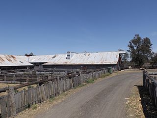
Jondaryan Woolshed is a heritage-listed shearing shed at Evanslea Road, Jondaryan, Queensland, Australia. It was built in 1859-60 to replace an earlier, smaller woolshed on the former Jondaryan pastoral station, which was at one stage the largest freehold station in Queensland. The woolshed was the scene of significant labour conflict in the late 1880s and early 1890s, as the station became a test case for the new Queensland Shearers Union in the lead-up to the 1891 Australian shearers' strike.

John Riddoch was a pastoralist and politician in the State of South Australia, brother and business partner of George Riddoch.
Robert Rowland Leake was a sheep farmer politician in the early days of the colony of South Australia.

Mount Dutton Bay is a coastal locality in the Eyre and Western region of South Australia, situated in the District Council of Lower Eyre Peninsula. The name and boundaries were formalised in October 2003 in respect of the long established local name which is derived from the body of water known as Mount Dutton Bay. The locality incorporates three older residential "shack sites": Mount Dutton Bay West, on Dolphin Drive, Mount Dutton Bay East, on Woolshed Drive, and Shelley Beach/Salt Creek, on Shelly Beach Road. It is part of the cadastral Hundred of Lake Wangary.