
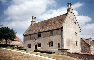
Woolsthorpe Manor in Woolsthorpe-by-Colsterworth, near Grantham, Lincolnshire, England, is the birthplace of Sir Isaac Newton and his family home. The orchard in the grounds is home to the famous Newton apple tree. A Grade I listed building, it is now owned by the National Trust and open to the public.
Woolsthorpe-by-Colsterworth is a hamlet in the South Kesteven district of Lincolnshire, England. It is best known as the birthplace of Sir Isaac Newton.

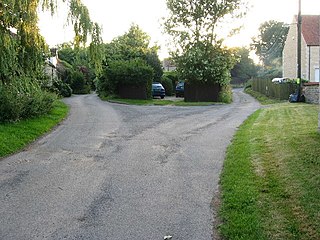
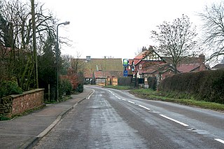
Woolsthorpe by Belvoir, also known as Woolsthorpe is a village and civil parish in the South Kesteven district of Lincolnshire, England. The population of the civil parish at the 2011 census was 415. It is situated approximately 5 miles (8 km) west from Grantham, and adjoins the county border with Leicestershire. The neighbouring village of Belvoir lies on the other side of the border. Grantham Canal is situated 1 mile (1.6 km) to the north-east at its closest point.

South Kesteven is a local government district in Lincolnshire, England, forming part of the traditional Kesteven division of the county. Its council is based in Grantham. The district also includes the towns of Bourne, Market Deeping and Stamford, along with numerous villages and surrounding rural areas.

The Grantham Canal ran 33 miles (53 km) from Grantham through 18 locks to West Bridgford, where it joined the River Trent. It was built primarily for the transportation of coal to Grantham. It opened in 1797 and its profitability steadily increased until 1841. It was then sold to a railway company, declined, and was finally closed in 1936. It was used as a water supply for agriculture, and so most of it remained in water after closure, although bridges were lowered. Since the 1970s, the Grantham Canal Society have been working to restore parts of it. Two stretches are now navigable to small vessels. A new route will be required where the canal joins the Trent, as road building has severed the original one.

The River Devon is a tributary of the River Trent, which rises in Leicestershire and joins the Trent at Newark in Nottinghamshire, England. In its upper reaches, it supplies Knipton Reservoir, which was built to supply water to the Grantham Canal, and Belvoir Lakes, designed by Capability Brown. It passes under the Grantham Canal, and then through Bottesford, where it is spanned by five railway bridges, only one of which is still used for its original purpose. On the outskirts of Newark, it passes by two Civil War structures, and just before it joins the Trent it becomes navigable, with a marina located on the west bank. Its name is pronounced "Deevon", not as spelt.

Denton is a village and civil parish in the South Kesteven district of Lincolnshire, England. The population of the civil parish was 273 at the 2011 census. It is situated approximately 3 miles (5 km) both south-west of Grantham and west from the A1 road.

Long Bennington is a linear village and civil parish in South Kesteven district of Lincolnshire, England, just off the A1 road, 7 miles (11 km) north of Grantham and 5 miles (8 km) south of Newark-on-Trent. It had a population of 2,100 in 2014 and 2,018 at the 2011 Census.
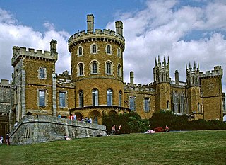
Belvoir is a village and civil parish in the Melton district of Leicestershire, England, close to the county boundary with Lincolnshire. The nearest town is Grantham, 13 kilometres (8 mi) east of the village.
Harlaxton is a village and civil parish in the South Kesteven district of Lincolnshire, England. It lies on the edge of the Vale of Belvoir and just off the A607, 2 miles (3 km) south-west from Grantham and 12 miles (19 km) north-east from Melton Mowbray.

Leadenham is a village and civil parish in the North Kesteven district of Lincolnshire, England. The population of the civil parish at the 2011 census was 410. It lies 11 miles (18 km) north of Grantham, 14 miles (23 km) south of Lincoln and 9 miles (14 km) north west of Sleaford the A607 between Welbourn and Fulbeck, and at the southern edge of the Lincoln Cliff.

Colsterworth is a village and civil parish in the South Kesteven district of Lincolnshire, England, less than half a mile (0.8 km) west of the A1, about 7 miles (11 km) south of Grantham, and 12 miles (19 km) north-west of Stamford. The village with the hamlet of Woolsthorpe-by-Colsterworth had a recorded population of 1,713 at the time of the 2011 census, in an area of 1,465 hectares.
Knipton is a village and former civil parish, now in the parish of Belvoir, in the Melton district, in the county of Leicestershire, England. It lies about 6 miles (10 km) from the town of Grantham, just off the A607, and 10 miles (16 km) from Melton Mowbray. It borders the Duke of Rutland's estate at Belvoir Castle. Although the village is in Leicestershire, it has a Nottinghamshire postcode and a Lincolnshire (Grantham) STD code. In 1931 the parish had a population of 273. On 1 April 1936 the parish was abolished and merged with Belvoir.
Gunby is a village and former civil parish, now in the parish of Gunby and Stainby, in the South Kesteven district of Lincolnshire, England. It is situated close to the borders with Leicestershire and Rutland, and 9 miles (14 km) south from Grantham, and 2 miles (3 km) west from the A1 road. In 1921 the parish had a population of 119. On 1 April 1931 the parish was abolished and merged with Stainby to form "Gunby and Stainby".
Stainby is a village and former civil parish, now in the parish of Gunby and Stainby, in the South Kesteven district of Lincolnshire, England. It is situated 2 miles (3.2 km) west from the A1 road, 1.5 miles (2.4 km) east from the Viking Way and the Leicestershire border, and 8 miles (13 km) south from Grantham. In 1921 the parish had a population of 117.
Old Somerby is a village and civil parish in the South Kesteven district of Lincolnshire, England, 3 miles (5 km) south-east of Grantham. It lies on the B1176 road, with the village centre about 1 mile (1.6 km) east of its junction with the A52 and B6403, and adjacent to the East Coast Main Line.
The Ambergate, Nottingham and Boston and Eastern Junction Railway was a British railway company, which hoped to connect Lancashire with the port of Boston, in Lincolnshire, England. It was authorised in 1846 but was unable to raise much money. It opened a standard gauge line from a junction near Nottingham to Grantham in 1853. At Nottingham it was to rely on the Midland Railway, but that company was hostile and obstructive.

Harston is a crossroads village and former civil parish, now in the parish of Belvoir, in the Melton district, in Leicestershire, England, near the border with Lincolnshire. The nearest town is Grantham, about 6 miles (10 km) to the north-east. It once contained several quarries for iron ore. Part of the village borders Lincolnshire. In 1931 the parish had a population of 182. On 1 April 1936 the parish was abolished and merged with Belvoir.

Skillington is a village and civil parish in the South Kesteven district of Lincolnshire, England. The population of the civil parish at the 2021 census was 314. It is situated 1.5 miles (2.4 km) west from the A1 road, 6 miles (10 km) south from Grantham, and is within 3 miles (5 km) of the Leicestershire border.

Casthorpe is hamlet in the civil parish of Barrowby and the South Kesteven District of Lincolnshire, England. It is 23 miles (40 km) south-southwest from the city and county town of Lincoln, 3 miles (5 km) west from Grantham town centre, and 1 mile (1.6 km) west from Barrowby village.