
The Central Coast is a peri-urban region lying on the Pacific Ocean in northern-eastern New South Wales, Australia. The region is situated north of Sydney, which is filled with subtropical national parks, forests and also encompasses the major coastal waterways of Brisbane Water, Tuggerah Lakes and southern Lake Macquarie. The region's hinterland, which has fertile valleys, rural farmland and wineries, and also includes the Watagan Mountains. The Central Coast is known for its regional coastal towns like Terrigal, The Entrance, Ettalong Beach, Budgewoi and Bateau Bay with resorts and holiday parks, which feature many expansive beaches and lagoons with surfing and coastal tracks, as well as scenic views. Gosford is the main commercial hub and gateway.

Wyong is a town on the Central Coast of New South Wales, Australia. It is located approximately 63 km SSW of Newcastle and 93 km NNE of the state capital Sydney. Established in 1888, it is one of the two administrative centres for the Central Coast Council local government area.

The City of Gosford was a local government area that was located in the Central Coast region in the state of New South Wales, Australia. The incorporation of Gosford dates back to 1886 when the Town of Gosford was proclaimed as the Borough of Gosford, becoming the Municipality of Gosford from 1906. In 1908, the Gosford Municipality merged into Erina Shire which covered the remaining Central Coast area outside of Gosford, but regained its independence in 1936. From 1 January 1947, local government in the Central Coast region was reorganised, creating Gosford Shire and Wyong Shire, and the final boundaries of Gosford City Council date from this period. From 1 January 1980, Gosford Shire was granted city status, becoming the City of Gosford. On 12 May 2016 the Minister for Local Government amalgamated the City of Gosford and Wyong Shire Councils. The Central Coast Council was established on the same day, covering the combined areas.

Wyong Shire was a local government area located in the Central Coast region of New South Wales, Australia. The incorporation of the Wyong area dates back to 7 March 1906 when the entire area of the Brisbane Water Police District outside of the Town of Gosford was proclaimed as the Erina Shire. From 1 January 1947, local government in the Central Coast region was reorganised, creating Gosford Shire and Wyong Shire, which comprised Erina Shire north and east of Kulnura, Central Mangrove and Lisarow.
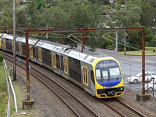
The Central Coast & Newcastle Line (CCN) is a NSW TrainLink passenger train service that runs along the Main North railway line in New South Wales, connecting the state's two largest cities, Sydney and Newcastle. The service runs from Central through to Broadmeadow on the Main North railway line to Newcastle Interchange on the Newcastle railway line, and services the Hawkesbury River region, the Central Coast and the city of Newcastle.
Toukley is a town in the Central Coast region of the Australian state of New South Wales and is located within Central Coast Council. It lies approximately 109 km north of Sydney and 54 km south of Newcastle via the Pacific Motorway (M1). It is located between Tuggerah Lake, Budgewoi Lake, and the Pacific Ocean. At the channel connecting Tuggerah Lake and Budgewoi Lake the new Toukley bridge was constructed between 1983 and 1985 linking Toukley on the eastern side of the Lakes system with Gorokan on the west, replacing the old two lane wooden bridge.

The Entrance is a coastal town and suburb in the Central Coast region of New South Wales, Australia. It is part of the Central Coast Council local government area. At the 2011 census, The Entrance had a population of 3,873 people.
Wyong is an electoral district of the Legislative Assembly in the Australian state of New South Wales. The district is a 640.55 km² urban and semi-rural electorate on the Central Coast. It covers part of Central Coast Council, including the towns of Wyong and Toukley.
Mangrove Creek Dam, a concrete faced rockfill embankment dam, is the primary reservoir for water supply to residents of the Central Coast in New South Wales, Australia.

Cedar Brush Creek is a suburb of the Central Coast region of New South Wales, Australia, located 24 kilometres (15 mi) upstream from Wyong along the Wyong River. It is part of the Central Coast Council local government area.
Tacoma is a suburb of the Central Coast region of New South Wales, Australia. It is part of the Central Coast Council local government area.
Yarramalong(cedar country) is a township and suburb of the Central Coast region of New South Wales, Australia, located 20 kilometres (12 mi) upstream from Wyong along the Wyong River. It is part of the Central Coast Council local government area.

Tascott is a suburb of the Central Coast region of New South Wales, Australia between Gosford and Woy Woy on Brisbane Water's western shore. It is part of the Central Coast Council local government area.

The Shire of Erina was a local government area covering the majority of the Central Coast region of New South Wales, Australia. The shire was proclaimed on 7 March 1906 as a result of the passing of the Local Government (Shires) Act 1905 and covered most of the Central Coast region with the exception of the Town of Gosford, which had been incorporated in 1886.

The Wyong River is a perennial river that is located in the Central Coast region of New South Wales, Australia.
Wyong, an electoral district of the Legislative Assembly in the Australian state of New South Wales, has had two incarnations, the first from 1962 to 1973, the second from 1988 to the present.

The Wyong Rugby League Football Club are an Australian rugby league club based on the Central Coast of New South Wales. The club competed in the New South Wales Cup from 2013 to 2018 and still competes in the Central Coast Division Rugby League. The club's colours are green and gold, the home ground of the club is the Morry Breen Oval in Kanwal, New South Wales.

Ourimbah Creek, a perennial river of the Central Coast catchment, is located in the Central Coast region of New South Wales, Australia.

The Central Coast Council is a local government area in the Central Coast region of New South Wales, Australia. It is adjacent to the Pacific Highway, Central Coast Highway, the Northern railway line and the Pacific Ocean. The council was formed on 12 May 2016 following the merger of the Gosford City and Wyong Shire Councils.
The Shire of Woy Woy was a local government area on the Central Coast region of New South Wales, Australia, centred on the town of Woy Woy. The shire was proclaimed on 1 August 1928 as a result of the proclamation of the separation of the D Riding of Erina Shire and had its council seat at Woy Woy, but covered the majority of the Woy Woy peninsula including Woy Woy Bay, Umina, Blackwall, Kariong, Pearl Beach, and Patonga. Woy Woy Shire was abolished on 1 January 1947 with the reorganisation of local government in the Central Coast region following the end of the Second World War, with the council area amalgamated into Gosford Shire.