The geography of Malta is dominated by water. Malta is an archipelago of coralline limestone, located in the Mediterranean Sea, 81 kilometres south of Sicily, Italy, and nearly 300 km north (Libya) and northeast (Tunisia) of Africa. Although Malta is situated in Southern Europe, it is located farther south than Tunis, capital of Tunisia, Algiers, capital of Algeria, Tangier in Morocco and also Aleppo in Syria, and Mosul in Iraq in the Middle East. Only the three largest islands – Malta, Gozo and Comino – are inhabited. Other (uninhabited) islands are: Cominotto, Filfla and the St.Paul's Islands. The country is approximately 316 km2 in area. Numerous bays along the indented coastline of the islands provide harbours. The landscape of the islands is characterised by high hills with terraced fields. The highest point, at 253 metres, Ta' Zuta on mainland Malta. The capital is Valletta.

Żebbuġ is a small village overlooking the northwest coast of the island of Gozo in Malta. It is located close to Għarb and Għasri and is built on two hilltop plateaus, Ta' Abram and Ix-Xagħra taż-Żebbuġ. The fishing port and tourist resort of Marsalforn lies within the Żebbuġ Council. The village has a population of 2,956, which makes it the fifth largest in Gozo, after Xewkija.
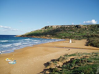
Ramla Bay is located at the bottom of a rich and fertile valley on the northern side of the island of Gozo. Gozo is one of the Maltese islands. The village of Xagħra, located on one of the hills of Gozo, overlooks this valley. It is about a forty-minute walk from Xagħra to the bay. The bay can also be reached from the village of Nadur. Bus service to the beach is very regular. The terraced walls built by the farmers give the valley an appearance of a quilt when viewed from the high ridges surrounding it.

Għajn Tuffieħa forms part of the Manikata village in Malta which is part of Mellieħa.
Marsalforn Tower refers to two towers that stood near Marsalforn, in the limits of Xagħra, Gozo, Malta. The first one was built in 1616, as the fourth of six Wignacourt towers, and collapsed in around 1715. The second was a Tour-reduit, which was built in 1720 and demolished in 1915.
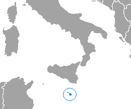
This is a list of the extreme points of the Malta. The points that are farther north, south, east or west than any other location. Malta is composed of an archipelago of seven islands.
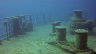
Um El Faroud was a 10,000 ton Libyan owned single screw motor tanker. Following a gas explosion during maintenance work in 1995, she was scuttled off the coast of Malta as an artificial reef and diving attraction.
No. 248 Squadron was a squadron of the Royal Air Force, active immediately after World War I, and again during World War II.

The Chiesa di San Giovanni del Toro is a church in Ravello, southern Italy.

Pasewalk (GS05) was a Kondor I-class minesweeper built in East Germany. After the Volksmarine was disbanded just before the reunification of Germany, she was sold to Malta in 1992 and renamed P31 and was used as a patrol boat. After being decommissioned, she was scuttled as a dive site in 2009 off Comino.

The Xlendi Bay to Wardija Point Cliffs Important Bird Area comprises a 32 ha, linear strip of cliffed coastline on the southern coast of the island of Gozo in the Maltese archipelago of the Mediterranean Sea. It extends from Wardija Point in the west for about 3 km to Xlendi Bay in the east, with the steep and rugged cliffs rising from sea level to a height of 105 m. It was identified as an Important Bird Area (IBA) by BirdLife International because it supports 350–500 breeding pairs of Cory's shearwaters and 30–50 pairs of vulnerable yelkouan shearwaters.
The iċ-Ċnus to tal-Bardan Cliffs Important Bird Area comprises a 19 ha linear strip of cliffed coastline at Munxar and Sannat, on the southern coast of the island of Gozo, in the Maltese archipelago of the Mediterranean Sea. Its steep and rugged cliffs rise from sea level to a height of 128 m. It was identified as an Important Bird Area (IBA) by BirdLife International because it supports 30 breeding pairs of yelkouan shearwaters.

Ta' Ċenċ Cliffs is a 20 ha linear strip of cliffed coastline at Sannat, on the southern coast of the island of Gozo, Malta, in the Mediterranean Sea. The area consists of garrigue and steep and rugged cliffs, which rise from sea level to a height of 120 m. The cliffs are identified as an Important Bird Area (IBA) by BirdLife International because they support 800–1000 breeding pairs of Cory's shearwaters and 150–300 pairs of yelkouan shearwaters.

The Dwejra Bay to San Dimitri Point Important Bird Area comprises a 36 ha linear strip of cliffed coastline in San Lawrenz and Għarb, at the north-western end of the island of Gozo, in the Maltese archipelago of the Mediterranean Sea. Its steep and rugged cliffs rise from sea level to a height of 105 m. It was identified as an Important Bird Area (IBA) by BirdLife International because it supports 400–500 breeding pairs of Cory's shearwaters and 30–50 pairs of yelkouan shearwaters.
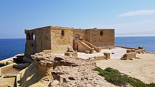
Qolla l-Bajda Battery is an artillery battery in Żebbuġ, Gozo, Malta. It was built by the Order of Saint John between 1715 and 1716 as one of a series of coastal fortifications around the coasts of the Maltese Islands. It retained its original layout until the late 1970s, when it was converted into a discothèque and snack bar known as Rook and major alterations were made to the battery. The building is now abandoned and in a dilapidated state, being in the midst of a legal battle between the government and a private company.
Saint Mary's Battery, also known as Qolla s-Safra Battery or Gironda Battery, was an artillery battery in Marsalforn, limits of Żebbuġ, Gozo, Malta. It was built by the Order of Saint John in 1715 as one of a series of coastal fortifications around the Maltese Islands.
Xwejni Redoubt was a redoubt in Xwejni Bay, limits of Żebbuġ, Gozo, Malta. It was built by the Order of Saint John between 1715 and 1716 as one of a series of coastal fortifications around the coasts of the Maltese Islands.

Qbajjar Bay is a small bay near Marsalforn, in the limits of Żebbuġ on the island of Gozo, Malta. It is located between Xwejni Bay to the west, and Marsalforn Bay to the east. The 18th century, Qolla l-Bajda Battery, one of the few surviving coastal fortifications in Gozo, is located between Qbajjar and Xwejni, on a promontory known as il-Ponta tat-Torri.
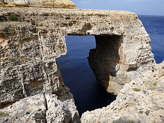
The Wied il-Mielaħ Window is a limestone natural arch on the north-western coast of the island of Gozo in Malta. It is located at the end of the valley Wied il-Mielaħ north of the village of Għarb. This natural arch is less well-known than the Azure Window, which collapsed in March 2017 following a heavy storm.

Marsalforn Bay is a bay located in Marsalforn, Gozo.