
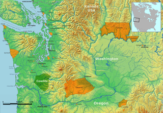
The Columbia River is the largest river in the Pacific Northwest region of North America. The river rises in the Rocky Mountains of British Columbia, Canada. It flows northwest and then south into the U.S. state of Washington, then turns west to form most of the border between Washington and the state of Oregon before emptying into the Pacific Ocean. The river is 1,243 miles (2,000 km) long, and its largest tributary is the Snake River. Its drainage basin is roughly the size of France and extends into seven US states and a Canadian province. The fourth-largest river in the United States by volume, the Columbia has the greatest flow of any North American river entering the Pacific. The Columbia has the 36th greatest discharge of any river in the world.

The Yakima River is a tributary of the Columbia River in south central and eastern Washington state, named for the indigenous Yakama people. The length of the river from headwaters to mouth is 214 miles (344 km), with an average drop of 9.85 feet per mile (1.866 m/km). It is the longest river entirely in Washington state.
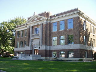
Benton County is a county in the south-central portion of the U.S. state of Washington. As of the 2020 census, its population was 206,873. The county seat is Prosser, and its largest city is Kennewick. The Columbia River demarcates the county's north, south, and east boundaries.

The Yakama are a Native American tribe with nearly 10,851 members, based primarily in eastern Washington state.
The term Cowlitz people covers two culturally and linguistically distinct indigenous peoples of the Pacific Northwest; the Lower Cowlitz or Cowlitz proper, and the Upper Cowlitz / Cowlitz Klickitat or Taitnapam. Lower Cowlitz refers to a southwestern Coast Salish people, which today are enrolled in the federally recognized tribes: Cowlitz Indian Tribe, Quinault Indian Nation, and Confederated Tribes of the Chehalis Reservation. The Upper Cowlitz or Taitnapam, is a Northwest Sahaptin speaking people, part of the Confederated Tribes and Bands of the Yakama Nation.
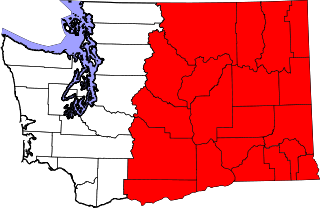
Eastern Washington is the region of the U.S. state of Washington located east of the Cascade Range. It contains the city of Spokane, the Tri-Cities, the Columbia River and the Grand Coulee Dam, the Hanford Nuclear Reservation and the fertile farmlands of the Yakima Valley and the Palouse. Unlike in Western Washington, the climate is dry, including some desert environments.

Gifford Pinchot National Forest is a National Forest located in southern Washington, managed by the United States Forest Service. With an area of 1.32 million acres (5300 km2), it extends 116 km along the western slopes of Cascade Range from Mount Rainier National Park to the Columbia River. The forest straddles the crest of the South Cascades of Washington State, spread out over broad, old growth forests, high mountain meadows, several glaciers, and numerous volcanic peaks. The forest's highest point is at 12,276 ft. at the top of Mount Adams, the second tallest volcano in the state after Rainier. Often found abbreviated GPNF on maps and in texts, it includes the 110,000-acre (450 km2) Mount St. Helens National Volcanic Monument, established by Congress in 1982.

The Columbia River drainage basin is the drainage basin of the Columbia River in the Pacific Northwest region of North America. It covers 668,000 km2 or 258,000 sq mi. In common usage, the term often refers to a smaller area, generally the portion of the drainage basin that lies within eastern Washington.

Central Washington is a region of the U.S. state of Washington between the western and eastern parts of the state extending from the border with the Canadian province of British Columbia in the north to the border with the U.S. state of Oregon in the south. Generally, the western edge is the Cascade Range and the eastern edge is in the vicinity of the 119th meridian west.

The Columbia Basin Project in Central Washington, United States, is the irrigation network that the Grand Coulee Dam makes possible. It is the largest water reclamation project in the United States, supplying irrigation water to over 670,000 acres (2,700 km2) of the 1,100,000 acres (4,500 km2) large project area, all of which was originally intended to be supplied and is still classified as irrigable and open for the possible enlargement of the system. Water pumped from the Columbia River is carried over 331 miles (533 km) of main canals, stored in a number of reservoirs, then fed into 1,339 miles (2,155 km) of lateral irrigation canals, and out into 3,500 miles (5,600 km) of drains and wasteways. The Grand Coulee Dam, powerplant, and various other parts of the CBP are operated by the Bureau of Reclamation. There are three irrigation districts in the project area, which operate additional local facilities.

The Klickitat River is a tributary of the Columbia River, nearly 96 miles (154 km) long, in south-central Washington in the United States. It drains a rugged plateau area on the eastern side of the Cascade Range northeast of Portland, Oregon. In 1986, 10 miles (16 km) of the river were designated Wild and Scenic from the confluence with Wheeler Creek, near the town of Pitt, to the confluence with the Columbia River.
Indigenous peoples of the Northwest Plateau, also referred to by the phrase Indigenous peoples of the Plateau, and historically called the Plateau Indians are indigenous peoples of the Interior of British Columbia, Canada, and the non-coastal regions of the Northwestern United States.

The Yakima War (1855–1858) was a conflict between the United States and the Yakama, a Sahaptian-speaking people of the Northwest Plateau, then part of Washington Territory, and the tribal allies of each. It primarily took place in the southern interior of present-day Washington. Isolated battles in western Washington and the northern Inland Empire were sometimes separately referred to as the Puget Sound War and the Palouse War, respectively. This conflict is also referred to as the Yakima Native American War of 1855.

The Klickitat are a Native American tribe of the Pacific Northwest. Today most Klickitat are enrolled in the federally recognized Confederated Tribes and Bands of the Yakama Nation, some are also part of the Confederated Tribes of the Grand Ronde Community of Oregon.

Condit Hydroelectric Project was a development on the White Salmon River in the U.S. state of Washington. It was completed in 1913 to provide electrical power for local industry, and is listed in the National Register of Historic Places as an engineering and architecture landmark.
The Klickitat Trail is a 31-mile (50 km) rail trail along the Klickitat River in southern Washington in the Columbia River Gorge. The cycling and hiking trail offers river and canyon views throughout its length. It follows an old railroad corridor that at one time linked the towns of Lyle and Goldendale.

Established in 1849, the Vancouver Barracks was the first U.S. Army base located in the Pacific Northwest. Built on a rise 20 feet above the Hudson's Bay Company (HBC) trading station Fort Vancouver. Its buildings were formed in a line adjacent to the Columbia River about 2,000 yards from the water. It is now located within modern Vancouver, Washington.

Kachess Lake is a lake and reservoir along the course of the Kachess River in Washington state, US. The upper part of the lake, north of a narrows, is called Little Kachess Lake. The Kachess River flows into the lake from the north, and out from the south. Kachess Lake is the middle of the three large lakes which straddle Interstate 90 north of the Yakima River in the Cascade Range. The other two are Cle Elum Lake, the easternmost which is also north of I-90 and Keechelus Lake, the westernmost, which is south of I-90.

Keechelus Lake is a lake and reservoir in the northwest United States, near Hyak in Kittitas County, Washington. Approximately fifty miles (80 km) southeast of Seattle and a few miles southeast of Snoqualmie Pass, it is the source of the Yakima River.

The East Fork Lewis River is a river in the state of Washington in the United States. It is the largest tributary of the Lewis River. Its source is on Green Lookout Mountain in Skamania County. It then flows to the west through Clark County until it converges with the Lewis about 3.5 mi (5.6 km) upstream from the Columbia River.