
The Metropolitan Area Express (MAX) is a light rail system serving the Portland metropolitan area in the U.S. state of Oregon. Owned and operated by TriMet, it consists of five lines connecting the six sections of Portland; the communities of Beaverton, Clackamas, Gresham, Hillsboro, Milwaukie, and Oak Grove; and Portland International Airport to Portland City Center. Trains run seven days a week with headways of between 30 minutes off-peak and three minutes during rush hours. In 2019, MAX had an average daily ridership of 120,900, or 38.8 million annually. Due to the COVID-19 pandemic, which impacted public transit use globally, annual ridership plummeted, with only 14.8 million riders recorded in 2021.
Yamhill or Yam Hill may refer to:

The MAX Blue Line is a light rail line serving the Portland metropolitan area in the U.S. state of Oregon. Operated by TriMet as part of the MAX Light Rail system, it connects Hillsboro, Beaverton, Portland, and Gresham. The Blue Line is the longest in the network; it travels approximately 33 miles (53 km) and serves 48 stations from Hatfield Government Center to Cleveland Avenue. It is the busiest of the five MAX lines, having carried an average 55,370 riders each day on weekdays in September 2018. Service runs for 221⁄2 hours per day from Monday to Thursday, with headways of between 30 minutes off-peak and five minutes during rush hour. It runs later in the evening on Fridays and Saturdays and ends earlier on Sundays.

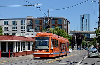
The MAX Yellow Line is a light rail line serving Portland, Oregon, United States. Operated by TriMet as part of the MAX Light Rail system, it connects North Portland, Portland City Center, and Portland State University (PSU). The line serves 17 stations; it runs north–south from Expo Center station to PSU South/Southwest 6th and College station, interlining with the Green and Orange lines within the Portland Transit Mall. Service runs for 21 hours per day with headways of up to 15 minutes. The Yellow Line is the fourth-busiest service in the MAX system; it carried an average 12,960 riders per weekday in September 2019.

The Skidmore Fountain station is a light rail station on the MAX Blue and Red Lines in Portland, Oregon. It is currently the fifth stop eastbound on the Eastside MAX. It was previously also served by the Yellow Line, from 2004 to 2009, until that line's relocation to the Portland Transit Mall.

Oak Street/Southwest 1st Avenue is a light rail station on the MAX Blue and Red Lines in Portland, Oregon. It the 4th stop on the current Eastside MAX. It was previously also served by the Yellow Line, from 2004 to 2009, until that line's relocation to the Portland Transit Mall.

Mall/Southwest 4th Avenue and Mall/Southwest 5th Avenue were a pair of light rail stations in Portland, Oregon, United States, served by TriMet as part of the MAX Light Rail system. Built into the sidewalk at Southwest Yamhill and Morrison streets between 4th and 5th avenues in downtown Portland, the Mall stations were served by the Blue and Red lines upon closing. They had also been served by the Yellow Line from May 2004 to August 2009.

Library/Southwest 9th Avenue and Galleria/Southwest 10th Avenue are light rail stops on the MAX Blue and Red Lines in Portland, Oregon. It was the original western terminus and is now the Eastside MAX line's first stop eastbound/last stop westbound in downtown.

Pioneer Square South and Pioneer Square North are a pair of light rail stations in Portland, Oregon, United States, served by TriMet as part of the MAX Light Rail system. Situated directly west of the Portland Transit Mall at Pioneer Courthouse Square in downtown Portland, they occupy the sidewalk on Yamhill and Morrison streets between Broadway and 6th Avenue. The stations consist of one side platform each; trains traveling eastbound stop at Pioneer Square South while trains traveling westbound stop at Pioneer Square North.

Like transportation in the rest of the United States, the primary mode of local transportation in Portland, Oregon is the automobile. Metro, the metropolitan area's regional government, has a regional master plan in which transit-oriented development plays a major role. This approach, part of the new urbanism, promotes mixed-use and high-density development around light rail stops and transit centers, and the investment of the metropolitan area's share of federal tax dollars into multiple modes of transportation. In the United States, this focus is atypical in an era when automobile use led many areas to neglect their core cities in favor of development along interstate highways, in suburbs, and satellite cities.
Portland is "an international pioneer in transit orientated developments."

Downtown Portland is the central business district of Portland, Oregon, United States. It is on the west bank of the Willamette River in the northeastern corner of the southwest section of the city and where most of the city's high-rise buildings are found.

Pioneer Place is an upscale, urban shopping mall in downtown Portland, Oregon. It consists of four blocks of retail, dining, parking, and an office tower named Pioneer Tower. The mall itself is spread out between four buildings, interconnected by skywalks or underground mall sections. The footprint of the entire complex consists of four full city blocks, bisected by SW Yamhill and Fourth, bounded north-south by SW Morrison and Taylor Streets and east-west by SW Third and Fifth Avenues. In 2014, Pioneer Place was the third-highest selling mall in the United States based on sales per square foot, sitting just behind Bal Harbour Shops and The Grove at Farmers Market.

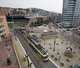
The MAX Green Line is a light rail service in Portland, Oregon, United States, operated by TriMet as part of the MAX Light Rail system. It is 15 miles (24.1 km) long and serves 30 stations from the PSU South stations to Clackamas Town Center Transit Center; it connects Portland State University (PSU), Portland City Center, Northeast Portland, Southeast Portland, and Clackamas. The Green Line is the only service that shares parts of its route with the four other MAX services, sharing the Portland Transit Mall with the Orange and Yellow lines and the Banfield segment of the Eastside MAX with the Blue and Red lines. Southbound from Gateway/Northeast 99th Avenue Transit Center, it operates the Interstate 205 (I-205) segment through to Clackamas Town Center. Service runs for approximately 211⁄2 hours daily with a headway of 15 minutes during most of the day. It is the third-busiest line in the system, carrying an average of 19,160 riders per day on weekdays in September 2019.
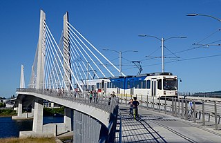
The MAX Orange Line is a light rail line serving the Portland metropolitan area in the U.S. state of Oregon. Operated by TriMet as part of the MAX Light Rail system, it connects Portland City Center, Portland State University (PSU), Southeast Portland, Milwaukie, and Oak Grove. The line serves 17 stations and runs for 201⁄2 hours per day with headways of up to 15 minutes. It averaged 3,480 daily weekday riders in September 2020.
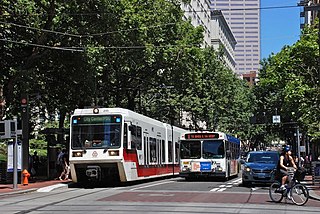
The Portland Transit Mall is a 1.2-mile (1.9 km) public transit corridor that travels north–south through the center of downtown in Portland, Oregon, United States. It comprises a pair of one-way streets—6th Avenue for northbound traffic and 5th Avenue for southbound—along which two of three lanes are restricted to transit buses and light rail vehicles only. As of September 2022, the corridor is served by the Green, Orange, and Yellow lines of MAX Light Rail; Frequent Express; and over a dozen local bus routes, all of which are services of TriMet, the transit agency operating within the Oregon side of the Portland metropolitan area. C-Tran, the transit agency for Clark County, Washington, additionally serves it with two express bus routes—#105 I-5 Express and #164 Fisher’s Landing Express.

PSU South/Southwest 6th and College and PSU South/Southwest 5th and Jackson are a pair of light rail stations on the MAX Green, Orange and Yellow Lines in Portland, Oregon. Together, they serve as the southern passenger terminus—one for departures only and the other for arrivals only—of the Portland Transit Mall MAX line. The stations opened on September 2, 2012.

Southwest 6th & Pine and Southwest 5th & Oak stations are a pair of light rail stations on the MAX Green, Orange and Yellow Lines in Portland, Oregon. It is the 3rd stop southbound on the Portland Transit Mall extension.

Pioneer Courthouse/Southwest 6th and Pioneer Place/Southwest 5th stations are a pair of light rail stations on the MAX Green, Orange and Yellow Lines in Portland, Oregon. They are the 4th stop southbound on the Portland Transit Mall MAX extension. The Pioneer Courthouse/Southwest 6th station is served only by the Green and Yellow Lines, and the Pioneer Place/Southwest 5th station is served only by the Green and Orange Lines. Originally, from the opening of these stations in 2009 until 2015, the Yellow Line served both, but in September 2015 the then-new Orange Line replaced the Yellow Line at all southbound stations on the transit mall.
Providence Park is a light rail station on the MAX Blue and Red lines located in the Goose Hollow neighborhood of Portland, Oregon. It is named after the adjacent stadium, Providence Park. The station primarily serves Providence Park and residential areas around West Burnside Street. The station, consisting of separate eastbound and westbound platforms built into city sidewalks between SW 17th and SW 18th Avenues on SW Yamhill and SW Morrison Streets, opened on August 31, 1997.
The North South Line is a streetcar service of the Portland Streetcar system in Portland, Oregon, United States. Operated by Portland Streetcar, Inc. and TriMet, it travels approximately 4.1 miles (6.6 km) per direction from Northwest 23rd & Marshall to Southwest Lowell & Bond and serves 39 stations. The line connects Portland's Northwest District, Pearl District, downtown, Portland State University (PSU), and South Waterfront. It runs every day of the week between 15 and 18 hours per day and operates on headways of 15 to 20 minutes.

