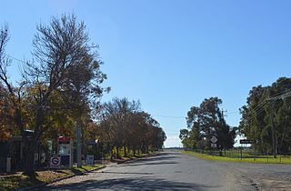
Yandumblin is a rural locality of Hay Shire Council and a civil parish of Nicholson County, [1] [2] in the Riverina region of Australia.

Yandumblin is a rural locality of Hay Shire Council and a civil parish of Nicholson County, [1] [2] in the Riverina region of Australia.
The parish located at 33°47′54″S 144°59′04″E is flat, semi-arid and the main economic activity is agriculture. The Parish 750 km (460 mi) from Sydney is on the Lachlan River and Yandumblin Creek. There are no towns in the parish though the town and river crossing of Booligal, New South Wales is just outside the parish.
Yandumblin is situated on the traditional boundary of the Muthi Muthi and Nari Nari Aboriginal tribes.
Pastoralists arrived in the area in the 1850s. [3] and the nearby town of Boooligal was established in July 1860. [4]

Murrumbidgee River, a major tributary of the Murray River within the Murray–Darling basin and the second longest river in Australia. It flows through the Australian state of New South Wales and the Australian Capital Territory. It descends 1,500 metres (4,900 ft) as it flows 1,485 kilometres (923 mi) in a west-northwesterly direction from the foot of Peppercorn Hill in the Fiery Range of the Snowy Mountains towards its confluence with the Murray River near Boundary Bend.

Hay is a town in the western Riverina region of south western New South Wales, Australia. It is the administrative centre of Hay Shire local government area and the centre of a prosperous and productive agricultural district on the wide Hay Plains.

Cumberland County is a county in the State of New South Wales, Australia. Most of the Sydney metropolitan area is located within the County of Cumberland.

The Riverina is an agricultural region of South-Western New South Wales (NSW), Australia. The Riverina is distinguished from other Australian regions by the combination of flat plains, warm to hot climate and an ample supply of water for irrigation. This combination has allowed the Riverina to develop into one of the most productive and agriculturally diverse areas of Australia. Bordered on the south by the state of Victoria and on the east by the Great Dividing Range, the Riverina covers those areas of New South Wales in the Murray and Murrumbidgee drainage zones to their confluence in the west.

George William Evans was a surveyor and early explorer in the Colony of New South Wales. Evans was born in Warwick, England, migrating to Australia in October 1802.

Booligal is a village in the Riverina area of western New South Wales (NSW), Australia. It is located on the Cobb Highway, on the Lachlan River north of Hay. Booligal is a part of Hay Shire local government area.

Maude is a village on the north bank of the Murrumbidgee River in New South Wales, Australia. It is in between Hay and Balranald in Hay Shire. It is located 55 kilometres downstream from Hay and 25 kilometres upstream from the junction of the Lachlan River with the Murrumbidgee. At the 2006 census, Maude had a population of 161 people. Maude consists of a General Store, hotel, post office and caravan park. The town is surrounded by market gardens supplied with water from Maude Weir, a popular spot for anglers, looking for yellow belly, redfin and Murray cod.

Kyalite is a locality on the Wakool River in the Riverina district of the Australian state of New South Wales. It is part of Balranald Shire and is approximately 890 kilometres (550 mi) south west of the state capital Sydney and 400 kilometres (250 mi) north west of Melbourne. Kyalite was formerly known as Wakool Crossing. At the 2006 census, Kyalite had a population of 108.

Oxley is a community on the lower Lachlan River in the Riverina district of New South Wales, Australia near the junction of the Lachlan and Murrumbidgee Rivers. The township which developed in the mid-1860s was named after the noted Australian explorer, John Oxley. At the 2006 census, Oxley had a population of 159 people.

The lands administrative divisions of New South Wales refers to the 141 counties within the Colony of New South Wales, that later became the Australian state of New South Wales.

Waljeers County is one of the 141 Cadastral divisions of New South Wales. It contains the town of Booligal.

Nicholson County is one of the 141 Cadastral divisions of New South Wales. It contains the towns of Hillston, Goolgowi, Gunbar, Merriwagga, Goorawin and Langtree. The Lachlan River is its north-western boundary.

The Nari-Nari are an Indigenous Australian group in the Riverina region of New South Wales, Australia. The Nari-Nari are believed by historians to have formed in the Balranald area on the lower Murrumbidgee River, from the amalgamation of a number of groups in neighbouring areas such as the Wiradjuri and the Watiwati. The Nari-Nari share a western border with the Muthi Muthi tribe.

The Lowbidgee Floodplain extends from Balranald to near Waradgery Station, about 20 km (12 mi) west of Hay, in south-western New South Wales. The Lowbidgee Floodplain is part of the Traditional lands of the Nari Nari and Muthi Muthi Aboriginal peoples.

The 1813 crossing of the Blue Mountains was the expedition led by Gregory Blaxland, William Lawson and William Charles Wentworth, which became the first successful crossing of the Blue Mountains in New South Wales by European settlers. The crossing enabled the settlers to access and use the land west of the mountains for farming, and made possible the establishment of Australia's first inland settlement at Bathurst.

The Muthi Muthi people are an indigenous Australian people whose traditional lands are located in the Northern Riverina and Far West regions of New South Wales.

European land exploration of Australia deals with the opening up of the interior of Australia to European settlement which occurred gradually throughout the colonial period, 1788–1900. A number of these explorers are very well known, such as Burke and Wills who are well known for their failed attempt to cross the interior of Australia, as well as Hamilton Hume and Charles Sturt.
The Jitajita, otherwise spelt Yitayita, are an indigenous Australian people of southern New South Wales.

Mulla Mulla is a rural locality in Hay Shire Council and a civil parish of Nicholson County in New South Wales, and is located at 33°48′54″S 145°05′04″E.
Moon Moon, New South Wales is a rural locality of Hay Shire Council and a civil parish of Nicholson County. in the Riverina region of Australia.