Related Research Articles
Paraguay, officially the Republic of Paraguay, is one of only two landlocked countries in South America. It is bordered by Argentina to the south and southwest, Brazil to the east and northeast, and Bolivia to the northwest. Paraguay lies on both banks of the Paraguay River, which runs through the center of the country from north to south. Due to its central location in South America, it is sometimes referred to as Corazón de Sudamérica.
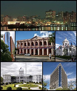
Asunción is the capital and largest city of Paraguay. The city is located on the left bank of the Paraguay River, almost at the confluence of this river with the River Pilcomayo, on the South American continent. The Paraguay River and the Bay of Asunción in the northwest separate the city from the Occidental Region of Paraguay and Argentina in the south part of the city. The rest of the city is surrounded by the Central Department.
The Triple Frontier is a tri-border area along the junction of Paraguay, Argentina and Brazil, where the Iguazú and Paraná rivers converge. Near the confluence are the cities of Ciudad del Este (Paraguay); Puerto Iguazú (Argentina) and Foz do Iguaçu (Brazil). This area is near Iguazú Falls and the Itaipú hydroelectric plant.

The Paraguayan War, also known as the War of the Triple Alliance and the Great War in Paraguay, was a South American war fought from 1864 to 1870, between Paraguay and the Triple Alliance of Argentina, the Empire of Brazil, and Uruguay. It was the deadliest and bloodiest inter-state war in Latin America's history. It particularly devastated Paraguay, which suffered catastrophic losses in population: almost 70% of its adult male population died, according to some counts, and it was forced to cede territory to Argentina and Brazil. According to some estimates, Paraguay's pre-war population of 525,000 was reduced to 221,000, of which only 28,000 were men.
San Pedro is a department of Paraguay. The capital is the city of San Pedro de Ycuamandiyú.

Encarnación is a district and the capital city of Itapúa Department in Paraguay, located at the south-east of the department, on the right-hand (western) shore of the Paraná River, opposite Posadas, Argentina. The city has an area of 274 km² and a population of 93,497. Encarnación is the third-largest city of Paraguay.
Minga Porá is a district of the Alto Paraná Department, Paraguay.

Fort Griswold is a former American defensive fortification in Groton, Connecticut named after Deputy Governor Matthew Griswold. The fort played a key role in the early stages of the American Revolutionary War, in correspondence with Fort Trumbull on the opposite side of the Thames River. Griswold defended the port of New London, Connecticut, a supply center for the Continental Army and friendly port for Connecticut-sanctioned privateers who attacked British ships. The 17-acre site is maintained as Fort Griswold Battlefield State Park by the Connecticut Department of Energy and Environmental Protection.
Oliver Cove Marine Provincial Park, also known as Port Blackney, is a provincial park at the southwest end of the Don Peninsula on the North Coast of British Columbia, Canada. It is accessible only by boat, but lacks docks or other facilities. The park comprises 26 hectares of marine area and 48 hectares of land area.
Little Island railway station serves the area of Little Island in County Cork.

The Little Suncook River is a 4.0-mile-long (6.4 km) river located in central New Hampshire in the United States. It is a tributary of the Suncook River, part of the Merrimack River watershed.

The Paraguay campaign (1810–11) was the attempt by a Buenos Aires-sponsored militia, commanded by Manuel Belgrano, to win the royalist Intendency of Paraguay for the cause of May Revolution. In Paraguay it is considered as their War of Independence. The first battles fought were the Battle of Campichuelo and Battle of Campo Maracana, in which Argentinians claimed victory. However, they were completely vanquished in the subsequent Battle of Paraguarí and Battle of Tacuarí. The campaign ended in a military failure and Paraguay broke its links with the Spanish crown just two months after Belgrano's withdrawal, starting its course towards full independence.
Pimentel District is one of twenty districts of the Chiclayo province in Peru. The beach and reed watercraft caballitos de totora are among its most popular attractions.

Rothley is a small settlement and civil parish in Northumberland, England about 2 miles (3 km) north east of Cambo and about 6 miles (10 km) west of Morpeth.

The Monday River is a river of Paraguay. It flows and empties into the Parana River, just south of the tri-border mark point of the Triple Frontier. Its primary course lies almost entirely within the Alto Parana Department.

The Apa River is a river of Paraguay and Brazil. It is a tributary of the Paraguay River, which in turn is a tributary of the Paraná River. It starts in the Amambai Mountains of the Brazilian state of Mato Grosso do Sul. The Apa forms part of the border between Paraguay and Brazil beginning at the twin cities of Bella Vista Norte and Bela Vista.

The Acaray River is a river in eastern Paraguay. It is born in the Cordillera de Caaguazú, and is joined by the Yguazú and Itakyry rivers later on. The river flows through the Caaguazú and Alto Paraná Departments, and joins the Paraná River in an area between Ciudad del Este and Hernadarias, which was later modified for the construction of the Acaray Dam. One of its main tributaries is the Yguazú River, which also has its own dam: the Yguazú Dam.

The Dhalai River a trans-boundary river in India and Bangladesh. It rises in the mountains of the Indian state of Tripura. It enters Kulaura Upazila of Maulvi Bazar District of Bangladesh. Later it joins Manu River in Rajnagar Upazila.
Green Township is a township in Nodaway County, in the U.S. state of Missouri.
References
- Rand McNally, The New International Atlas, 1993.
- GEOnet Names Server
Coordinates: 24°21′19″S54°56′08″W / 24.3553°S 54.9356°W

A geographic coordinate system is a coordinate system that enables every location on Earth to be specified by a set of numbers, letters or symbols. The coordinates are often chosen such that one of the numbers represents a vertical position and two or three of the numbers represent a horizontal position; alternatively, a geographic position may be expressed in a combined three-dimensional Cartesian vector. A common choice of coordinates is latitude, longitude and elevation. To specify a location on a plane requires a map projection.
| This article related to a river in Paraguay is a stub. You can help Wikipedia by expanding it. |