A hub is the central part of a wheel that connects the axle to the wheel itself.
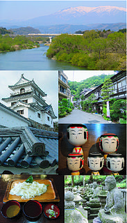
Shiroishi is a city in Miyagi Prefecture, Japan. As of 31 May 2020, the city had an estimated population of 33,330 and a population density of 120 persons per km2 in 14,242 households. The total area of the city is 286.48 square kilometres (110.61 sq mi).

Yamagata is the capital city of Yamagata Prefecture located in the Tōhoku region of northern Japan. As of 1 February 2020, the city had an estimated population of 248,772 in 103,165 households, and a population density of 650 persons per km2. The total area of the city is 381.58 square kilometres (147 sq mi).

Zaō is a town located in Miyagi Prefecture, Japan. As of 31 March 2020, the town had an estimated population of 11,790, and a population density of 77 persons per km² in 4,493 households. The total area of the town is 152.84 square kilometres (59.01 sq mi).
Shichikashuku is a town located in Katta District, Miyagi Prefecture, Japan. As of 1 June 2020, the town had an estimated population of 1,323, and a population density of 5.0 persons per km² in 626 households. The total area of the town is 263.09 square kilometres (101.58 sq mi).

Kawasaki is a town located in Miyagi Prefecture, Japan. As of 31 May 2020, the town had an estimated population of 8,637 and a population density of 32 persons per km2 in 3,391 households. The total area of the town is 270.77 square kilometres (104.54 sq mi).

The Zaō Mountains, commonly called Mount Zaō, are a complex cluster of stratovolcanoes on the border between Yamagata Prefecture and Miyagi Prefecture in Japan. The central volcano of the group includes several lava domes and a tuff cone, Goshiki-dake, which contains a crater lake named "Okama". Also known as the "Five Color Pond" because it changes color depending on the weather, it lies in a crater formed by a volcanic eruption in the 1720s. The lake is 360 metres (1,200 ft) in diameter and 60 m (200 ft) deep, and is one of the main tourist attractions in the area.

Simly Dam is an 80 meters (260 ft) high earthen embankment dam on the Soan River, 30 kilometers (19 mi) east of Islamabad and Rawalpindi in Rawalpindi District, Punjab, Pakistan. It is the largest reservoir of drinking water to people living in Islamabad, the capital of Pakistan. The water stored in this dam is fed by the melting snow & natural springs of Murree hills. It was developed by the Capital Development Authority. Planning for the dam began in 1962 and it was not completed when expected in 1972 due to project delays. It was completed in 1983.

Zaō Station is a railway station in the city of Yamagata, Yamagata Prefecture, Japan, operated by East Japan Railway Company.
Mohmand Dam is an under construction multi-purpose concrete-faced rock-filled dam located on the Swat River approximately 37 km north of Peshawar and 5 km upstream of Munda Headworks in Mohmand District, Khyber Pakhtunkhwa, Pakistan.

Zaō Quasi-National Park is a Quasi-National Park that extends in the Ōu Mountains between Miyagi and Yamagata Prefectures, Japan. Established in 1963, the central feature of the park is Mount Zaō. It is rated a protected landscape according to the IUCN.
Bunji Dam is proposed large hydro-power project on Indus River in Bunji, Gilgit Baltistan, Pakistan. If built it would be Pakistan's second largest hydropower project.

The Natori River is a river located in central Miyagi prefecture, in the Tōhoku region of northern Japan. It starts at Mount Kamuro in the Ōu Mountains and flows in an easterly direction through the cities of Natori and Sendai. The river's headwaters start in the Zao Mountain range, it flows through the Sendai Plain and ends by draining into Sendai Bay. The river's estuary is located on Japan's east coast, and faces the Pacific Ocean. The river's flow is the greatest during the snow melt season from March to April, the rainy season from June to July and during the typhoon season from September to October. The river's length is 55 km, and its tributaries are the Hirose, Masuda and Goishi Rivers. The Natori provides water for 1 million people in the city of Sendai.
Zao Dam is a small earth core rock-fill dam in Khyber Agency of FATA, Pakistan.

Mount Minami Katsuragi is the tallest mountain in the Izumi Mountains within the Kongō Range, straddling the border between Osaka and Wakayama Prefectures in Japan. Its peak elevation is 922 metres (3,025 ft).
Zao Dam is a rockfill dam located in Shiga prefecture in Japan. The dam is used for irrigation. The catchment area of the dam is 9.4 km2. The dam impounds about 33 ha of land when full and can store 4790 thousand cubic meters of water. The construction of the dam was started on 1972 and completed in 1990.
Zao Dam is a hollow gravity dam located in Yamagata prefecture in Japan. The dam is used for flood control and water supply. The catchment area of the dam is 21 km2. The dam impounds about 24 ha of land when full and can store 7300 thousand cubic meters of water. The construction of the dam was started on 1965 and completed in 1969.