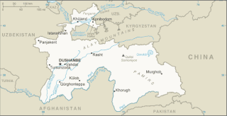
Tajikistan is nestled between Kyrgyzstan and Uzbekistan to the north and west, China to the east, and Afghanistan to the south. Mountains cover 93 percent of Tajikistan's surface area. The two principal ranges, the Pamir Mountains and the Alay Mountains, give rise to many glacier-fed streams and rivers, which have been used to irrigate farmlands since ancient times. Central Asia's other major mountain range, the Tian Shan, skirts northern Tajikistan. Mountainous terrain separates Tajikistan's two population centers, which are in the lowlands of the southern and northern sections of the country. Especially in areas of intensive agricultural and industrial activity, the Soviet Union's natural resource utilization policies left independent Tajikistan with a legacy of environmental problems.

Panjakent, or Penjikent is a city in the Sughd province of Tajikistan on the river Zeravshan, with a population of 52,500. It was once an ancient town in Sogdiana. The ruins of the old town are on the outskirts of the modern city. The Sarazm Important Bird Area lies downstream of the city on the tugay-vegetated floodplain of the river.

Zarafshon is a city in the center of Uzbekistan's Navoiy Region. Administratively, it is a district-level city, that includes the urban-type settlement Muruntau. It has 85,100 inhabitants (2021). Located in the Kyzylkum desert, it receives water from the Amudarya by a 220-km pipeline.
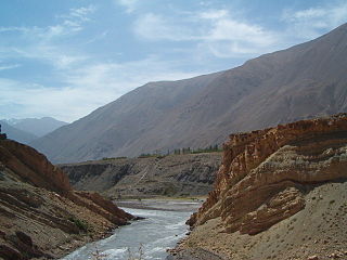
The Zeravshan is a river in Tajikistan and Uzbekistan, Central Asia. Its name, "spreader of gold" in Persian, refers to the presence of gold-bearing sands in the upper reaches of the river. To the ancient Greeks it was known as the Polytimetus. It was also formerly known as Sughd River. The river is 877 kilometres (545 mi) long and has a basin area of 17,700 square kilometres (6,800 sq mi).
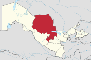
Navoiy Region is one of the regions of Uzbekistan. It is located in the central north/northwest of the country. It covers an area of 111,095 km2 (42,894 sq mi), which makes it the largest of the regions of Uzbekistan. The Navoiy region borders with Kazakhstan, Samarqand Region, Buxoro Region, Jizzakh Region, and the Karakalpakstan Republic. The population is estimated 1,013,600 (2021), with 51% living in rural areas. The capital is Navoiy. The region and its capital are named after the poet Ali-Shir Nava'i.
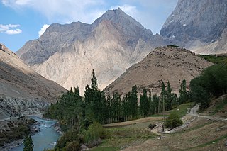
The Yaghnob is a river in Ayni District of Sughd Region, Tajikistan. Together with the Iskander Darya, it forms the Fan Darya, a major left tributary of the Zeravshan.

Qizilqum Zarafshon is an Uzbeki football club based in Zarafshan. They play in the Uzbekistan Super League. Club is named after the Zeravshan River that flows nearby. Qizylqum in Uzbek means Red Sands, which also is the name of the local desert.

Ayni District, also Aini District, is a district in the southern part of Sughd Region, Tajikistan, straddling the middle course of the river Zeravshan. Its capital is the town of Ayni, located on the Zeravshan. The population of the district is 83,600. It was named after the Tajik national poet Sadriddin Ayni. India established a base at Ayni in Tajikistan, which was used to assist the Northern Alliance during the Taliban regime.

Dardar is a village and jamoat in Ayni District in Sughd Region in north-west Tajikistan, not far from the border with Uzbekistan. It is situated on the northern bank of the Zeravshan, along Highway A377, to the northwest of Ayni on the road to Urmetan. The jamoat has a total population of 7,562 (2015). It consists of 6 villages, including Dardar, Iskodar, Khayrobod and Zerobod. Approaching the town the "wide ivan of a mosque dating from the 19th century can be seen from the road".

Hissor Range is a mountain range in Central Asia, in the western part of the Pamir-Alay system, stretching over 200 km in the general east–west direction across the territory of Tajikistan and Uzbekistan.

One of the northern extensions of the Pamir-Alay system, the Turkestan Range stretches for a total length of 340 km from the Alay Mountains on the border of Kyrgyzstan with Tajikistan to the Samarkand oasis in Uzbekistan. It runs in the east–west direction, north of the Zeravshan Range, forming the southern boundary of the Ferghana Valley in Tajikistan and Golodnaya Steppe in Uzbekistan. The highest elevations are in the east, near the border with Kyrgyzstan. The maximum elevation is the Pik Skalisty at 5,621 metres (18,442 ft). Glaciation occurs especially in the east. The southern slopes are bare cliffs and mountain steppe; the northern slopes are covered with forests. A highway through the Shakhristan Pass at 3,378 meters (11,083 ft) connects the capital Dushanbe with Khujand in Northern Tajikistan.
Articles related to Tajikistan include:
Poykent, an ancient city in Uzbekistan, is located in the lower stream of Zarafshan River and was one of the largest cities of the oasis. The city consisted of a citadel, two settlements, and a rabod (suburb). Poykent is currently under consideration for inscription as a UNESCO World Heritage site.

Zarafshan is a town in north-west Tajikistan. It is situated on the northern slope of the Gissar Range. It is located in Ayni District in Sughd Region. The town has a total population of 2,400.

Jondor District is a district of Bukhara Region in Uzbekistan. The capital lies at the town Jondor. Its population is 179,300 (2021).
Rustam Zairovich Zabirov is Uzbek-Tajik football manager and former football player and coach. He played for Pamir Dushanbe, Navbahor Namangan, Rubin Kazan and other clubs.

The Zarafshan Range is a mountain range in Tajikistan and Uzbekistan, part of the Pamir-Alay mountains. Almost all of the range belongs to the drainage basins of the Zarafshan River.
The Karatag or Qoratagʻ is a river of northwestern Tajikistan and eastern Uzbekistan. It flows through Shirkent National Park and flows down the south slopes of the Gissar mountain range. At its confluence with the Toʻpolondaryo, the Surxondaryo is formed. The river is 112 kilometres (70 mi) long. Large seismic landslides occur in the river basin and it also contains several glacial lakes. Upstream from the confluence with the Payron, the Karatag is called Diakhandara. Another tributary is the Zambar. The Diakhandara Glacier, which fed the upper course of the Karatag, has fully melted.

The Bocharic myotis or Bokhara whiskered bat is a species of mouse-eared bat in the family Vespertilionidae, described in 1950, and indigenous to Tajikistan, and Uzbekistan.
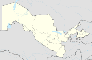
Muruntau is an urban-type settlement in the Navoiy Region, Uzbekistan. Administratively, it is part of the city Zarafshon. The town's population in 1989 was 9193 people.


