Harbor Hills is a census-designated place (CDP) in Licking County, Ohio, United States. The population was 1,303 at the 2000 census.

Bradner is a village in Wood County, Ohio, United States. The population was 985 at the 2010 census.

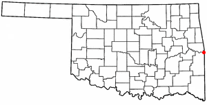
Arkoma is a town in Le Flore County, Oklahoma, United States. It is part of the Fort Smith, Arkansas-Oklahoma Metropolitan Statistical Area. The population was 1,989 at the 2010 census, a decline from 2,180 in 2000. The name of the town is a portmanteau of Arkansas and Oklahoma. Throughout its history, Arkoma has served as a "bedroom community" because many residents commuted to work in Fort Smith.

Almena is a town in Barron County in the U.S. state of Wisconsin. The population was 858 at the 2010 census. The Village of Almena is partially located within the town.

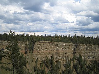
Chasm Provincial Park is a provincial park in British Columbia, Canada, located near the town of Clinton. Expanded to 3,067 hectares in 1995, the park was originally created in 1940 to preserve and promote a feature known as the Painted Chasm, or simply The Chasm, a gorge created from melting glacial waters eroding a lava plateau over a 10 million year span called the Chilcotin Group.
The Horsepasture River is an 18.1-mile-long (29.1 km) National Wild and Scenic river in the U.S. states of North Carolina and South Carolina. The river rises in Jackson County, North Carolina, and flows through the Jocassee Gorges area and ends at Lake Jocassee in South Carolina. Some of the land over which the river flows is part of the Pisgah National Forest, making it accessible to the public.

Alton is a small village of about 250 residents within the town of Richmond, Rhode Island. It is located about one hour south of Providence, the state's capital. The village is primarily residential, with no retail stores. Alton is located at a crossing of the Wood River and is 5 miles from the Pawcatuck River.

Etlatongo is an archaeological site in Oaxaca, Mexico. Situated in the Nochixtlán Valley within the Mixteca Alta, Etlatongo encompasses both a Formative Period site, located between two rivers, and a Classic/Post-classic site, on a hill to the north.

Star Mill is an unincorporated community in Lima Township, LaGrange County, Indiana.
Palmyra is an unincorporated community in Montgomery County, Tennessee. It is located along State Route 149, southwest of Clarksville. The town had its own post office until around 2010 when the post office was closed and mail service began to be handled out of nearby Clarksville. The zip code for Palmyra is 37142. Palmyra has a rich Civil War history with Major General Joseph Wheeler of the Confederate army took position on the Cumberland River in late January 1863. His plan was to disrupt Union ships going to Fort Donelson at Dover, a few miles west of Palmyra. Aware of Wheeler's intentions, the Union did not send any ships up or down the river, forcing Wheeler to attack Fort Donelson with his cavalry division. Wheeler was unable to take Fort Donelson and had to retreat after sustaining heavy losses.
Leon is an unincorporated community located in Madison County, Virginia, United States.
Ferry Farm is an unincorporated community in Stafford County, in the U.S. state of Virginia.

Claraville is an unincorporated community in Northumberland County, in the U.S. state of Virginia.
Peatross is an unincorporated community in Caroline County, in the U.S. state of Virginia.
Rowes Haven is an unincorporated community in Gloucester County, in the U. S. state of Virginia.
Osage Bluff is an unincorporated community in Cole County, in the U.S. state of Missouri.

Quintana is a ward (barrio) of Madrid belonging to the district of Ciudad Lineal.
Honey Creek is a stream in Cole County in central Missouri. It is a tributary of the Moreau River.
Lost Creek is a stream in Crawford and Washington counties in the U.S. state of Missouri. It is a tributary of Courtois Creek.

Woodcrest is an unincorporated community in Washington Township, Morgan County, in the U.S. state of Indiana.


