
Suldal is a municipality in the northeast corner of Rogaland county, Norway. It is located in the traditional district of Ryfylke. Since 1965, the administrative centre of Suldal is the village of Sand i Ryfylke. Other villages in Suldal include Hålandsosen, Jelsa, Marvik, Nesflaten, and Suldalsosen.

Strand is a municipality in Rogaland county, Norway. It is located in the traditional district of Ryfylke. The administrative centre of the municipality is the town of Jørpeland. The municipality lies across the fjord from the city of Stavanger. The new Ryfast tunnel system is under construction, which will connect Stavanger and Strand by a very long undersea tunnel.
Fister is a village in Hjelmeland municipality in Rogaland county, Norway. The village is located on the mainland, along the Fisterfjorden, a branch off the main Boknafjorden. The village lies about 8 kilometres (5.0 mi) northwest of the village of Årdal and about 10 kilometres (6.2 mi) southwest of the municipal centre of Hjelmelandsvågen.

Hjelmelandsvågen is the administrative centre of Hjelmeland municipality, Norway. The village is located on the south side of the mouth of the Jøsenfjorden. The 0.67-square-kilometre (170-acre) village has a population (2015) of 558, giving the village a population density of 833 inhabitants per square kilometre (2,160/sq mi).
Nilsebuvatnet is a lake in the municipalities of Forsand and Hjelmeland in Rogaland county, Norway. The 2.47-square-kilometre (0.95 sq mi) lake lies in the Lyseheiane mountains about 13 kilometres (8.1 mi) north of the village of Lysebotn and about 25 kilometres (16 mi) east of the village of Årdal. The lake is regulated by a small dam on the southwest corner of the lake. The dam provides water for the Lysebotn power station. The lake drains out into the river Storåna which flows westward towards Årdal. The lake is accessible by a small service road from Lysebotn which leads up to the dam.

Tysdalsvatnet or Tyssdalsvatnet is a lake in the municipalities of Hjelmeland and Strand in Rogaland county, Norway. The 3.74-square-kilometre (1.44 sq mi) lake lies about 5 kilometres (3.1 mi) south of the village of Årdal and about 8 kilometres (5.0 mi) east of the village of Tau. The Norwegian National Road 13 (Rv13) runs along the northern side of the lake. The Svo Tunnel was completed in 2013 and it routes much of Rv13 through a mountain rather than along the narrow shoreline of the lake.
Øvre Tysdalsvatnet is a lake in the municipality of Hjelmeland in Rogaland county, Norway. The 9-square-kilometre (3.5 sq mi) lake lies on the east side of the village of Årdal. The 12-kilometre (7.5 mi) long lake is only about 800 metres (0.5 mi) wide and it has a fairly steep shoreline, which results in very little habitation around the lake.

Årdal is a former municipality in Rogaland county, Norway. The 558-square-kilometre (215 sq mi) municipality existed from 1859 until 1965. It stretched from the head of the Årdalsfjorden in the west to the county border in the east. It encompassed the southern half of the present-day municipality of Hjelmeland. The administrative centre of the municipality was the village of Årdal where the Old Årdal Church is located.
Årdal or Aardal may refer to:

Randøy Bridge is a suspension bridge in Hjelmeland municipality in Rogaland county, Norway. The bridge crosses the Ølesundet strait and links the island of Randøy to the mainland. The bridge has a main span of 202 metres (663 ft). The bridge opened in 1976 as part of County Road Fv650. The bridge is located 4.5 kilometres (2.8 mi) southwest of the village of Hjelmelandsvågen and about the same distance northeast of the village of Fister.
Årdal Church may refer to:
Jelsa is a former municipality in Rogaland county, Norway. The 130-square-kilometre (50 sq mi) municipality existed from 1838 until 1965. It encompassed area in the present-day municipalities of Suldal, Hjelmeland, and Finnøy that surround the Sandsfjorden. The administrative centre was the village of Jelsa, where Jelsa Church is located.

Fister is a former municipality in Rogaland county, Norway. The 47-square-kilometre (18 sq mi) municipality existed from 1884 until 1965. It was located in the present-day municipalities of Finnøy and Hjelmeland. The administrative centre of the municipality was the village of Fister, where the Fister Church is located. The municipality encompassed the western coast of mainland along the Fisterfjorden plus the islands to the west of the mainland, including the western part of Randøy and Halsnøya.
Hjelmeland og Fister is a former municipality in Rogaland county, Norway. The municipality existed from 1859 until 1884. It encompassed the area of today's Hjelmeland municipality plus the eastern islands in today's Finnøy municipality. The administrative centre of the municipality was the village of Hjelmelandsvågen. There were two churches in the municipality: Fister Church and Hjelmeland Church.

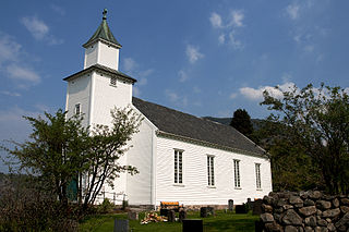
Årdal Church is a parish church in Hjelmeland municipality in Rogaland county, Norway. It is located in the village of Årdal. The church is part of the Årdal parish in the Ryfylke deanery in the Diocese of Stavanger. The white, wooden church was built in 1919 by the architect Einar Halleland. The church, which seats about 250 people, was built to replace the Old Årdal Church which is located nearby. Since it is the "new" church, it is also known as the Årdal nye kirke.

Hjelmeland Church is the main parish church in Hjelmeland municipality in Rogaland county, Norway. It is located in the village of Hjelmelandsvågen. The church is part of the Hjelmeland parish in the Ryfylke deanery in the Diocese of Stavanger. The white, wooden church was built in 1858 using plans by the architect Hans Linstow. The church seats about 500 people.
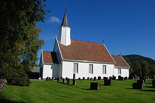
Fister Church is a parish church in Hjelmeland municipality in Rogaland county, Norway. It is located in the village of Fister. The church is part of the Fister parish in the Ryfylke deanery in the Diocese of Stavanger. The white, wooden church was built in 1867 using plans by the architect Hans Linstow. The church seats about 200 people.
Oltedal is a village in Gjesdal municipality in Rogaland county, Norway. The village is located in a narrow river valley about 11 kilometres (6.8 mi) northeast of the municipal centre of Ålgård and about 9 kilometres (5.6 mi) west of the village of Dirdal, just west of the Høgsfjorden. The lake Oltedalsvatnet lies on the southwestern edge of the village. Oltedal Church is located in the village. The village has some small industries such as yarn making, chemicals, and sand/gravel pits.


