
The French Southern and Antarctic Lands is an overseas territory of France. It consists of:
- Kerguelen Islands, a group of volcanic islands in the southern Indian Ocean, southeast of Africa, approximately equidistant between Africa, Antarctica and Australia;
- St. Paul and Amsterdam islands, a group to the north of Kerguelen;
- Crozet Islands, a group in the southern Indian Ocean, south of Madagascar;
- Adélie Land, the French claim on the continent of Antarctica;
- the Scattered Islands, a dispersed group of islands around the coast of Madagascar.
The French Antarctic Expedition is any of several French expeditions in Antarctica.

Mont Ross is a stratovolcano, the highest mountain in the Kerguelen Islands at 1,850 metres (6,070 ft). It is located in the Gallieni Massif, at the end of the Gallieni Peninsula, east of Baie Larose on the main island of Grande Terre. The volcano is composed primarily of trachybasalt and was active during the late Pleistocene.
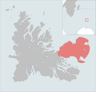
The Courbet Peninsula is a large peninsula in northeastern Grande Terre Island, the main island of the subantarctic Kerguelen Archipelago, Southern Indian Ocean. In the south of the peninsula is Port-aux-Français, the principal station of the archipelago.
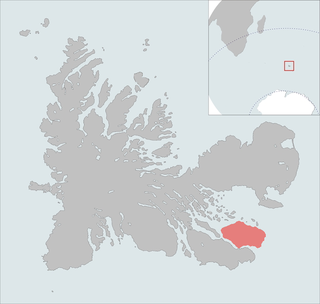
Ronarc'h Peninsula is a peninsula in the south-east of the principal island of Kerguelen, a subantarctic possession of France in the southern Indian Ocean. It is connected by a narrow strip of land to another peninsula, namely the Presqu'île Jeanne d'Arc to the southwest, which is approximately twice its area.

The Rallier du Baty Peninsula is a peninsula of Grande Terre, the main island of the subantarctic Kerguelen archipelago in the southern Indian Ocean. It occupies the south-western corner of the island, and is about 35 km long, extending from north to south, and 25 km across at its widest. The 1,202 m high Bicorne rises in the southern coast of the peninsula. It is named for Raymond Rallier du Baty, a French sailor who charted the archipelago in the early 20th century. The Îles Boynes, France's southernmost land apart from Adélie Land in Antarctica, lie 30 km south of the tip of the peninsula.

Baie Norvégienne is a small bay to the south east of the Péninsule Courbet, a vast peninsula constituting the north east quarter of the Kerguelen Islands in the Indian Ocean.
Imshaug Peninsula is a broad, snow-covered peninsula at the south side of Lehrke Inlet on the east coast of Palmer Land, Antarctica. It was mapped by the United States Geological Survey in 1974, and named by the Advisory Committee on Antarctic Names for Henry A. Imshaug, a United States Antarctic Research Program biologist working in a long-range biosystematic study of subantarctic floras with research at the Juan Fernández Islands, 1965–66; the Falkland Islands, 1967–68; the Chilean Archipelago, 1969; Campbell Island, 1969–70; and the Kerguelen Islands, 1970–71.
Aforia multispiralis is a species of sea snail, a marine gastropod mollusk in the family Cochlespiridae.

The Péninsule Loranchet, also known as Presqu'île Loranchet, is a peninsula of Grande Terre, the main island of the subantarctic Kerguelen archipelago in the southern Indian Ocean.
The Îles Nuageuses comprise a group of small islands that are part of the subantarctic Kerguelen archipelago, a French territory in the southern Indian Ocean. They are important as a breeding site for seabirds, especially penguins and albatrosses, and for fur seals.

The Gallieni Massif is a mountain range in Grande Terre, the main island of Kerguelen in the French Southern Territories zone of the Southern Indian Ocean.

Alfeus Island is the 310 m long in west-southwest to east-northeast direction and 120 m wide rocky island lying off the north coast of Smith Island in the South Shetland Islands, Antarctica.

Pingvin Rocks is the group of rocks in Morton Strait off the northeast coast of Snow Island in the South Shetland Islands, Antarctica extending 670 m in west–east direction and 300 m in south–north direction. The area was visited by early 19th-century sealers.

Rotalia Island is the rocky island off the north coast of Nelson Island in the South Shetland Islands, Antarctica extending 310 m in southeast-northwest direction and 250 m in southwest-northeast direction.
Kondor Island is the 320 m long in west–east direction and 140 m wide rocky island lying off the north coast of Nelson Island in the South Shetland Islands, Antarctica.
Fregata Island is the 480 m long in southeast-northwest direction and 230 m wide rocky island lying off the north coast of Nelson Island in the South Shetland Islands, Antarctica.

