Gjesdal is a municipality in Rogaland county, Norway. It is located in the traditional district of Jæren. The administrative centre of the municipality is the village of Ålgård. Other villages in Gjesdal include Dirdal, Frafjord, Gilja, Gjesdal, and Oltedal. The municipality lies about 25 kilometres (16 mi) to the southwest of the city of Stavanger in southwestern Norway.

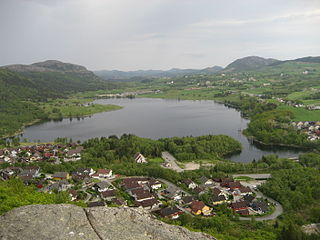
Suldal is a municipality in the northeast corner of Rogaland county, Norway. It is located in the traditional district of Ryfylke. Since 1965, the administrative centre of Suldal is the village of Sand i Ryfylke. Other villages in Suldal include Hålandsosen, Jelsa, Marvik, Nesflaten, and Suldalsosen.

Vikeså or Vigjeså is the administrative centre of Bjerkreim municipality in Rogaland county, Norway. The village is located along the European route E39 highway at a crossroads with the village of Ålgård about 20 kilometres (12 mi) to the northwest, the village of Dirdal about 25 kilometres (16 mi) to the northeast, and the town of Egersund about 20 kilometres (12 mi) to the south. The lake Svelavatnet lies along the south side of the village.
Eiavatnet is a lake in the municipalities of Eigersund and Sokndal in Rogaland county, Norway. The 4.29-square-kilometre (1.66 sq mi) lake is located about 15 kilometres (9.3 mi) east of the town of Egersund. The lake is regulated at an elevation of 139 metres (456 ft) so it can be used as a reservoir for the Lindland Power Station which is located a short distance north of Hauge in Sokndal. The lake Grøsfjellvatnet lies about 1 kilometre (0.62 mi) north of this lake.
Hofreistæ is a lake in the municipality of Bjerkreim in Rogaland county, Norway. The 2.66-square-kilometre (1.03 sq mi) lake immediately south of the village of Øvrebygd. The lake is fed by a short river from the lakes Austrumdalsvatnet and Byrkjelandsvatnet. The river Hofreistæåna flows south out of this lake and eventually feeds into the river Bjerkreimselva.
Nilsebuvatnet is a lake in the municipalities of Forsand and Hjelmeland in Rogaland county, Norway. The 2.47-square-kilometre (0.95 sq mi) lake lies in the Lyseheiane mountains about 13 kilometres (8.1 mi) north of the village of Lysebotn and about 25 kilometres (16 mi) east of the village of Årdal. The lake is regulated by a small dam on the southwest corner of the lake. The dam provides water for the Lysebotn power station. The lake drains out into the river Storåna which flows westward towards Årdal. The lake is accessible by a small service road from Lysebotn which leads up to the dam.
Vatsvatnet is a lake in the municipality of Vindafjord in Rogaland county, Norway. The 2.16-square-kilometre (0.83 sq mi) lake lies south of the European route E134 highway and north of the village of Vats. The long, narrow lake is 5.8 kilometres (3.6 mi) long, and has a maximum width of 900 metres (3,000 ft). The primary outflow of the lake is the river Åmselva which flows south into the Vatsfjorden.
Vostervatnet is a lake in the municipality of Strand in Rogaland county, Norway. The 2.62-square-kilometre (1.01 sq mi) lake lies in the northwestern part of Strand, just south of the Fognafjorden. The village of Tau lies about 3.5 kilometres (2.2 mi) southwest of the lake. The main outflow of the lake is the river Fiskåna, which flows north from the northeastern corner of the lake, down the hill to the village of Fiskå on the shore of the fjord.
Ørsdalsvatnet or Ørdalsvatnet is a lake in the municipality of Bjerkreim in Rogaland county, Norway. The 12.22-square-kilometre (4.72 sq mi) lake lies about 2 kilometres (1.2 mi) northeast of the village of Bjerkreim. The lake is rather narrow, but it is 15 kilometres (9.3 mi) long.
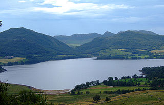
Øvre Tysdalsvatnet is a lake in the municipality of Hjelmeland in Rogaland county, Norway. The 9-square-kilometre (3.5 sq mi) lake lies on the east side of the village of Årdal. The 12-kilometre (7.5 mi) long lake is only about 800 metres (0.5 mi) wide and it has a fairly steep shoreline, which results in very little habitation around the lake.
Austrumdalsvatnet is a lake in the municipality of Bjerkreim in Rogaland county, Norway. The 2.81-square-kilometre (1.08 sq mi) lake lies about 2.5 kilometres (1.6 mi) southeast of the lakes Hofreistæ and Byrkjelandsvatnet. The village of Øvrebygd lies about 3 kilometres (1.9 mi) west of the lake.
Byrkjelandsvatnet or Storavatnet is a lake in the municipality of Bjerkreim in Rogaland county, Norway. The 5.17-square-kilometre (2.00 sq mi) lake lies about 2 kilometres (1.2 mi) north of the village of Øvrebygd. The lake flows out through the short river Malmeisåna which flows into the lake Hofreistæ.

Helleland is a village and parish in Eigersund municipality in Rogaland county, Norway. The village is located along the river Hedlandsåna and the European route E39 highway, about 13 kilometres (8.1 mi) northeast of the town of Egersund. The Sørlandet Line runs along the river near Helleland, stopping at Helleland Station.

Holmevatnet or Holmevatn is a lake in the Setesdalsheiene area of Norway. It is located in the mountains on the border of the municipalities of Bykle in Aust-Agder county and Suldal in Rogaland county. The 4.76-square-kilometre (1.84 sq mi) lake lies just west of the lake Store Urevatn and to the northeast of the lake Blåsjø. The nearest villages are Berdalen in Bykle, about 20 kilometres (12 mi) to the east and Suldalsosen, about 30 kilometres (19 mi) to the west. The mountain Kaldafjellet lies about 6 kilometres (3.7 mi) north of the lake.
Frøylandsvatnet is a lake in the municipality of Sandnes in Rogaland county, Norway. The 0.48-square-kilometre (120-acre) lake lies on the south side of the village of Hommersåk, about 10 kilometres (6.2 mi) northeast of the city of Sandnes. The lake empties into a small river that runs out of the north end of the lake. The river runs through Hommersåk into an arm of the Gandsfjorden.
Stakkastadvatnet is a lake on the border of Rogaland and Hordaland counties in Norway. The 2.92-square-kilometre (1.13 sq mi) lake mostly lies in Rogaland along the municipal borders of Haugesund and Tysvær. A very small portion of the northern part of the lake crosses over into the municipality of Sveio in Hordaland county. The lake lies about 6 kilometres (3.7 mi) northeast of the town of Haugesund. The lake has a small dam on the northwestern edge of the lake. The natural outlet of the lake flows through the dam and into the nearby lake Vigdarvatnet, located to the north.

Kulivatnet is a lake in the municipality of Sirdal in Vest-Agder county, Norway. It sits just 400 metres (1,300 ft) downhill from the border with Bjerkreim municipality in Rogaland county. The 2.16-square-kilometre (0.83 sq mi) lake is somewhat V-shaped and it has a small dam on the southeastern side to hold water for hydroelectric power generation. The water flows south through a series of dammed lakes before emptying into the river Sira at Tonstad, about 8 kilometres (5.0 mi) away.
Bjerkreim is a village in Bjerkreim municipality in Rogaland county, Norway. The village is located along the European route E39 highway about 7 kilometres (4.3 mi) south of the municipal centre of Vikeså. The river Bjerkreimselva runs through the village, right past Bjerkreim Church, the main church for the municipality.

Ivesdal Chapel is a parish church in Bjerkreim municipality in Rogaland county, Norway. It is located in the village of Øvrebygd. The church is part of the Bjerkreim parish in the Dalane deanery in the Diocese of Stavanger. The white, wooden church was built in 1876 by the architects Larsen and Helleland. The church seats about 210 people.


