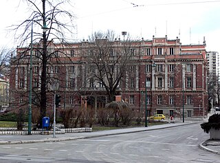
Centar is a municipality of the city of Sarajevo, Bosnia and Herzegovina. It is located between the older parts of the city under Stari Grad, and the newer more modern parts of the city under the municipalities Novi Grad and Novo Sarajevo.

Novo Sarajevo is a municipality of the city of Sarajevo, Bosnia and Herzegovina.
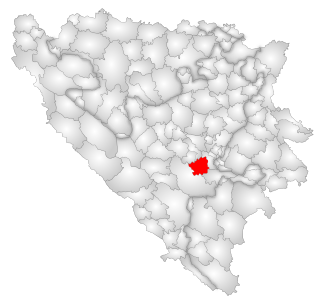
Hadžići is a town and a municipality located in Sarajevo Canton of the Federation of Bosnia and Herzegovina, an entity of Bosnia and Herzegovina. It is located south west of the city of Sarajevo. According to the census of 2013, Hadžići municipality has a population of 23,891 residents.

Olovo is a town and municipality located in Zenica-Doboj Canton of the Federation of Bosnia and Herzegovina, an entity of Bosnia and Herzegovina. It is situated about 50 kilometers northeast of the capital city of Sarajevo.
Hrasno is a neighbourhood in Sarajevo, Bosnia and Herzegovina. It is divided into four local communities: Hrasno, Staro Hrasno, Hrasno Brdo, and Trg Heroja. Staro Hrasno is located in the municipality of Novi Grad, while the other three local communities are parts of the Novo Sarajevo municipality. Before the Bosnian War, Hrasno, Staro Hrasno and Trg Heroja were considered to be a part of a single local community.

Sarajevo Synagogue is Sarajevo's primary and largest synagogue and is located on the south bank of the river Miljacka. It was constructed in 1902 and remains the only functioning synagogue in Sarajevo today.

The Church of the Holy Archangels Michael and Gabriel, also known as the Old Orthodox Church, is a Serbian Orthodox church in Sarajevo, Bosnia and Herzegovina. It was first mentioned in Ottoman sources dating to 1539. The Church was, however, built on older foundations).

The Church of the Holy Transfiguration is a Serbian Orthodox church in Novo Sarajevo, Sarajevo, Bosnia and Herzegovina.

Svrzo's House is an old house in Sarajevo, Bosnia and Herzegovina that was established when the Ottoman Empire ruled the area. It is a branch of the Museum of Sarajevo. It is typical in that it has living quarters for the men, the women, and the servants. The house is in extremely well preserved condition, which is noteworthy in that the house is built completely from wood; a construction method not commonly used in the region in modern times. It is open to the public for self-guided tours and has brochures and information in multiple languages.

The Eternal flame is a memorial to the military and civilian victims of the Second World War in Sarajevo, Bosnia and Herzegovina. The memorial was dedicated on 6 April 1946, the first anniversary of the liberation of Sarajevo from the four-year-long occupation by Nazi Germany and the fascist Independent State of Croatia.
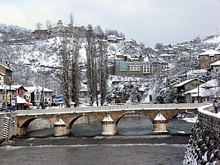
Šeher Ćehaja Bridge is a bridge which crosses the River Miljacka in Sarajevo, Bosnia and Herzegovina.

Despić House is an old merchant house in Sarajevo, Bosnia and Herzegovina that was established in 1881 by one of the wealthiest and most prominent Serb families in Sarajevo. It is a branch of the Museum of Sarajevo.
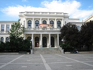
The Sarajevo National Theatre was founded in November 1921.

The Historical Museum of Bosnia and Herzegovina is a history museum in Sarajevo, Bosnia and Herzegovina.

The Ćumurija Bridge in Sarajevo, Bosnia and Herzegovina carries vehicular and pedestrian traffic over the River Miljacka. It was constructed in 1886.

The Skenderija Bridge is a footbridge located in Sarajevo, Bosnia and Herzegovina opposite the Skenderija Centre which crosses the River Miljacka. It was designed by Gustave Eiffel. The bridge is home to a small number of love locks, a phenomenon practiced by lovers on various European, Asian and Australian bridges.
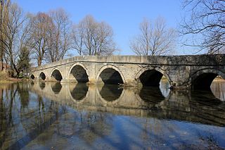
The Roman bridge on Ilidža is a bridge located in Sarajevo, Bosnia and Herzegovina.
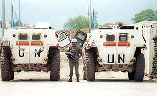
The Battle of Vrbanja Bridge was an armed confrontation which occurred on 27 May 1995 between United Nations (UN) peacekeepers from the French Army and elements of the Bosnian Serb Army of Republika Srpska (VRS). It began after the VRS seized French-manned United Nations Protection Force (UNPROFOR) observation posts on both ends of the Vrbanja Bridge crossing of the Miljacka river in Sarajevo, Bosnia and Herzegovina during the Bosnian War. Upon seizing the bridge, the VRS took the French peacekeepers hostage.
The following is a timeline of the history of the city of Sarajevo, Bosnia and Herzegovina.

Višnjik is a neighborhood in Sarajevo, Bosnia and Herzegovina.

