13th Street (Omaha)

Last updated
13th Street
Location Omaha
South end 41°11′08″N95°55′58″W / 41.1855°N 95.9327°W / 41.1855; -95.9327
North end 41°16′44″N95°55′59″W / 41.279°N 95.933°W / 41.279; -95.933
Construction
Inauguration 1854

13th Street is a two-way street that runs south-north in Omaha, Nebraska. Historically significant areas along the street include Squatter's Row, Little Italy, Little Bohemia, and Mount Vernon Gardens.

Omaha, Nebraska City in Nebraska, United States

Omaha is the largest city in the state of Nebraska and the county seat of Douglas County. Omaha is located in the Midwestern United States on the Missouri River, about 10 miles (15 km) north of the mouth of the Platte River. The nation's 40th-largest city, Omaha's 2018 estimated population was 466,061.

Squatter's Row was a historic neighborhood in the downtown area of Omaha, Nebraska. It was an area between North 11th and North 13th Streets, from Nicholas to Locust Streets, behind the Storz Brewery. For more than 75 years this area was inhabited solely by squatters. A village of shacks built of materials salvaged from the Omaha city dump, the neighborhood included different enclaves such as Vinegar Flats, Blind Pig Alley, among others.

Little Italy ethnic enclave

Little Italy is a general name for an ethnic enclave populated primarily by Italians or people of Italian ancestry, usually in an urban neighborhood. The concept of "Little Italy" holds many different aspects of the Italian culture. There are shops selling Italian goods as well as Italian restaurants lining the streets. A "Little Italy" strives essentially to have a version of the country of Italy placed in the middle of a big non-Italian city. This sort of enclave is often the result of periods of immigration in the past, during which people of the same culture settled together in certain areas. As cities modernized and grew, these areas became known for their ethnic associations, and towns like "Little Italy" blossomed, becoming the icons they are today.

Contents

History

13th Street was the original arterial from Nebraska City into Omaha used by pioneers, who generally stocked up in the city and then went westbound towards the prairies and the Great Platte River Road. [1] The street was later used to run electric streetcar service from Omaha to South Omaha. [2]

Great Platte River Road

The Great Platte River Road was a major overland travel corridor approximately following the course of the Platte River in present-day Nebraska and Wyoming that was shared by several popular emigrant trails during the 19th century, including the Trapper's Trail, the Oregon Trail, the Mormon Trail, the California Trail, the Pony Express route, and the military road connecting Fort Leavenworth and Fort Laramie. The road, which extended nearly 800 miles (1,300 km) from the Second Fort Kearny to Fort Laramie, was utilized primarily from 1841 to 1866. In modern times it is often regarded as a sort of superhighway of its era, and has been referred to as "the grand corridor of America's westward expansion".

Neighborhoods

Along with Squatter's Row, Little Bohemia, and Little Italy, there are several other neighborhoods along the route of 13th Street, including the Old Market, Spring Lake, and Deer Park. Communities include East Omaha, Downtown Omaha, South Omaha, and Bellevue.

Spring Lake is a historic neighborhood in Omaha, Nebraska. It is bounded by I-80 on the north, Missouri Avenue on the south, Highway 75 on the west and the Missouri River on the east. Spring Lake Park is also the name of an area park originally established as Syndicate Park. Spring Lake is bordered by the Deer Park neighborhood on the north and the city of Bellevue on the south.

Downtown Omaha

Downtown Omaha is the central business, government and social core of the Omaha-Council Bluffs metropolitan area, U.S. state of Nebraska. The boundaries are Omaha's 20th Street on the west to the Missouri River on the east and the centerline of Leavenworth Street on the south to the centerline of Chicago Street on the north, also including the CHI Health Center Omaha. Downtown sits on the Missouri River, with commanding views from the tallest skyscrapers.

Bellevue, Nebraska City in Nebraska, United States

Bellevue is a city in Sarpy County, Nebraska, United States and a southern suburb of Omaha. The population was 50,137 at the 2010 census. Bellevue is part of the Omaha-Council Bluffs metropolitan area. Originally settled in the 1830s, Bellevue was incorporated in 1855 and is the oldest continuous town in Nebraska. The Nebraska State Legislature has credited the town as being the second oldest settlement in Nebraska. It was once the seat of government in Nebraska.

The street goes by the site of the former Douglas House and the original Woodmen of the World Building, and historic buildings such as the Omaha Bolt, Nut and Screw Building, the G.C. Moses Block, Bohemian Cafe, Prague Hotel, Sokol Auditorium, Gallagher Building, and Stabrie Grocery. The Gene Leahy Mall is also along the street. Father Flanagan's first boys home was located along South 13th Street at the Old German Civic Center. [3] Rosenblatt Stadium, the old Rosewater School, and Mt. Vernon Gardens. The city's original Market House, built in the 1870s, was located on 13th Street and Capitol Avenue. [4]

The Douglas House was the second hotel in Omaha, Nebraska. Located in present-day Downtown Omaha on the southwest corner of 13th and Harney Streets, the hotel housed influential politicians, speculators, and the first court trial in the Nebraska Territory. A two-story frame structure, it supplemented the earlier St. Nicholas Hotel.

Woodmen of the World Building (Omaha, Nebraska)

The former Woodmen of the World Building in Omaha, Nebraska, was located at 1323 Farnam Street. Built in 1912 by the architectural firms of Holibard and Roche and Fisher and Lawrie, the building was the headquarters of Woodmen of the World (WOW) from 1912 until 1934. WOW relocated in 1934 to the Bee Newspaper Building at 17th and Farnam, also known as the Insurance Building.

Omaha Bolt, Nut and Screw Building

The Omaha Bolt, Nut and Screw Building is a warehouse building at 1316 Jones Street in Omaha, Nebraska, that was built in 1889. It was designed by architect Henry Voss for the Omaha Bolt, Nut & Screw Company, a hardware distributor based in Omaha. It was listed on the National Register of Historic Places in 1992 as part of a multiple property submission with other warehouses in Omaha that were part of an economically important "wholesale jobbing" industry that sprang up, taking advantage of Omaha's location and transportation links.

Connections

Beginning at the Missouri River in East Omaha and moving south, North 13th Street intersects with Locust Street to enter Carter Lake, Iowa. Moving through downtown, the first major connection is with Interstate 480. It then crosses Dodge Street, the major east-west low-density arterial in Omaha. The next major connection is connecting with Interstate 80, both east and west-bound connections. After intersecting with Deer Park Boulevard, the street crosses U.S. Route 275. After momentarily becoming Fort Crook Road, the street continues south into Bellevue and terminates in rural Sarpy County.

Missouri River major river in the central United States, tributary of the Mississippi

The Missouri River is the longest river in North America. Rising in the Rocky Mountains of western Montana, the Missouri flows east and south for 2,341 miles (3,767 km) before entering the Mississippi River north of St. Louis, Missouri. The river takes drainage from a sparsely populated, semi-arid watershed of more than half a million square miles (1,300,000 km2), which includes parts of ten U.S. states and two Canadian provinces. When combined with the lower Mississippi River, it forms the world's fourth longest river system.

Carter Lake, Iowa City in Iowa, United States

Carter Lake is a city in Pottawattamie County, Iowa, United States and a suburb of Omaha, Nebraska and sits surrounding the south and west sides of the region's major airport, Eppley Airfield. The population was 3,785 at the 2010 census.

Dodge Street is the main east–west street in Omaha, Nebraska. Numbered as U.S. Route 6 (US 6), the street starts in Downtown Omaha and connects to West Dodge Road around 78th Street. From there, it continues westward through the remainder of Douglas County.

See also

Related Research Articles

Council Bluffs, Iowa City in Iowa, United States

Council Bluffs is a city in and the county seat of Pottawattamie County, Iowa, United States. The city is the most populous in Southwest Iowa, and forms part of the Omaha (Nebr.) Metropolitan Area. It is located on the east bank of the Missouri River, across from the city of Omaha. Council Bluffs was known, until at least 1853, as Kanesville. It was the historic starting point of the Mormon Trail. Kanesville is also the northernmost anchor town of the other emigrant trails, since there was a steam powered boat to ferry their wagons, and cattle, across the Missouri River.

Interstate 480 (I-480) is a 4.90-mile-long (7.89 km) auxiliary Interstate Highway that connects Interstate 80 in downtown Omaha, Nebraska, with Interstate 29 in Council Bluffs, Iowa. The portion of I-480 in Nebraska has been named the Gerald R. Ford Expressway, named in honor of the former President, who was a native of Omaha. For most of its length, I-480 is overlapped by a U.S. Highway; for two miles (3.2 km) with U.S. Route 75 and for one mile (1.6 km) with U.S. Route 6. I-480 includes the Grenville Dodge Memorial Bridge over the Missouri River.

U.S. Route 34 highway in the United States

U.S. Route 34 is an east–west United States highway that runs for 1,122 miles (1,806 km) from north-central Colorado to the western suburbs of Chicago. Through Rocky Mountain National Park it is known as the Trail Ridge Road where it reaches elevation 12,183 feet (3,713 m), making it the highest paved through highway in the United States. The highway's western terminus is Granby, Colorado at U.S. Route 40. Its eastern terminus is in Berwyn, Illinois at Illinois Route 43 and Historic US 66.

Sokol Auditorium

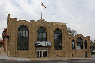
The Sokol Auditorium is located at 2234 South 13th Street in the Little Bohemia neighborhood of South Omaha, Nebraska. It is a local icon for its historical context, as well as modern musical performances and gymnastics. It has a maximum capacity of 1,500.

Nebraska Highway 370 highway in Nebraska

Nebraska Highway 370 (N-370) is an east–west state highway in Nebraska that is 15.98 miles (25.72 km) in length. It begins at U.S. Route 6 and Nebraska Highway 31 in Gretna, Nebraska and ends at the U.S. Route 75 interchange in Bellevue, Nebraska. It is the main east–west road in Sarpy County, Nebraska, which serves the southern Omaha suburbs. It is known as the Strategic Air Command Memorial Highway.

The neighborhoods of Omaha are a diverse collection of community areas and specific enclaves. They are spread throughout the Omaha metro area, and are all on the Nebraska side of the Missouri River.

The Near North Side of Omaha, Nebraska is the neighborhood immediately north of downtown. It forms the nucleus of the city's African-American community, and its name is often synonymous with the entire North Omaha area. It is bordered by Cuming Street on the south, 30th on the west, 16th on the east, and Locust Street to the north.

The Kountze Place neighborhood of Omaha, Nebraska is a historically significant community on the city's north end. Today the neighborhood is home to several buildings and homes listed on the National Register of Historic Places. It is located between North 16th Avenue on the east to North 30th Street on the west; Locust Street on the south to Pratt Street on the north. Kountze Place was annexed into Omaha in 1887. The neighborhood was built as a suburban middle and upper middle class enclave for doctors, lawyers, successful businessmen and other professional workers.

Little Italy is a neighborhood in Omaha, Nebraska. Historically the home to the city's Italian population, Little Italy was the source for much of Omaha's bootlegging during Prohibition, many laborers for the Union Pacific railroad, and the Santa Lucia Procession, which started in 1924 and continues annually.

Little Bohemia (Omaha, Nebraska) neighbourhood in Omaha, Nebraska

Little Bohemia, or Bohemian Town, is a historic neighborhood in Omaha, Nebraska. Starting in the 1880s, Czech immigrants settled in this highly concentrated area, also called "Praha" (Prague) or "Bohemian Town", bounded by South 10th Street on the east, South 16th Street on the west, Pierce Street on the north, and Martha Street on the south, with a commercial area went along South 13th and South 14th Streets, centered on William Street. It was located south of downtown, and directly west of Little Italy.

The Union Stockyards of Omaha, Nebraska were founded in 1883 in South Omaha by the Union Stock Yards Company of Omaha. A fierce rival of Chicago's Union Stock Yards, the Omaha Union Stockyards were third in the United States for production by 1890. In 1947 they were second to Chicago in the world. Omaha overtook Chicago as the nation's largest livestock market and meat packing industry center in 1955, a title which it held onto until 1971. The 116-year-old institution closed in 1999. The Livestock Exchange Building was listed on the National Register of Historic Places in 1999.

Vinton Street Commercial Historic District The Vinton Street Commercial Historic District is located along Vinton Street between Elm Street on the west and South 17th Street on the east in south Omaha, Nebraska

The Vinton Street Commercial Historic District is located along Vinton Street between Elm Street on the west and South 17th Street on the east in south Omaha, Nebraska. This district is located adjacent to Sheelytown, a residential neighborhood that had historically significant populations of Irish, Poles, and Eastern European immigrants. It grew along with the success of the Union Stockyards and South Omaha. It was added to the National Register of Historic Places in 2006.

Lincoln Boulevard in Omaha, Nebraska was built in the early 1890s as part of the city's boulevard system under control of the Board of Park Commissioners. It runs through the Bemis Park neighborhood west-east from Mercer Boulevard to its end at North 29 Street; it then reemerges immediately north of Dodge Street, where it intersects with Turner Boulevard.

Transportation in Omaha

Transportation in Omaha, Nebraska, includes most major modes, such as pedestrian, bicycle, automobile, bus, train and airplane. While early transportation consisted of ferries, stagecoaches, steamboats, street railroads, and railroads, the city's transportation systems have evolved to include the Interstate Highway System, parklike boulevards and a variety of bicycle and pedestrian trails. The historic head of several important emigrant trails and the First Transcontinental Railroad, its center as a national transportation hub earned Omaha the nickname "Gate City of the West" as early as the 1860s.

U.S. Highway 75 is a part of the United States Numbered Highway System that runs for 1,239 miles (1,994 km) from Dallas, Texas to Kittson County, Minnesota where it ends just short of the Canada–United States border. Within the State of Nebraska it is a state highway that enters Nebraska on the Kansas state line about 9 miles (14 km) south of Dawson and travels north across the extreme eastern portion of the state, to the Nebraska–Iowa border in South Sioux City where it crosses the Missouri River along a concurrency with Interstate 129. The northern 210 miles (340 km) of the route generally travels parallel to the Missouri River. The 87.32-mile (140.53 km) section between the I-680 interchange in Omaha and the Interstate 129 interchange is designated the Lewis & Clark Scenic Byway, one of nine scenic byways in the state.

North 30th Street is a two-way street that runs south-north in the North Omaha area of Omaha, Nebraska. With the street beginning at Dodge Street, historically significant sections include those from Dodge to Lake Street, from Fort Street to Laurel Avenue, and from Weber to Bondesson Streets.

Gibson Bend of the Missouri River is a meander located in Pottawattamie County, Iowa and Douglas County, Nebraska, located at 41°11′15″N95°55′15″W. The Gibson neighborhood is a community area in Omaha, Nebraska abutting the Gibson Bend.

The West Farnam neighborhood or the Blackstone neighborhood in Omaha, Nebraska is located from Dodge Street on the north to Leavenworth Street on the south, Highway 75/Interstate 480 on the east to South 52nd Street on the west. In 1997, the Gold Coast Historic District was formed from the West Farnam neighborhood and the Park Place neighborhood, known today as Cathedral. Named for its principal thoroughfare, West Farnam was a prime real estate area in the first quarter of the 20th century. It is home to several historical landmarks, including houses, churches, and former hotels.

References

  1. Morton, Julius Sterling (1906). Illustrated History of Nebraska: A History of Nebraska from the Earliest Explorations of the Trans-Mississippi Region, with Steel Engravings, Photogravures, Copper Plates, Maps, and Tables. J. North.
  2. United States investor, Volume 15, Part 1, Issues 1-26. Investor Publishing Company. 1904.
  3. Nebraska: A Guide to the Cornhusker State. University of Nebraska Press. 1979. ISBN   0803268513.
  4. Thomas' Revised Ordinances of the City of Omaha, Nebraska: Embracing All Ordinances of a General Nature in Force August 1, 1905, Together with the Charter for Metropolitan Cities. Klopp & Bartlett. 1905.

Coordinates: 41°14′02″N95°56′00″W / 41.234°N 95.9333°W / 41.234; -95.9333

Geographic coordinate system Coordinate system

A geographic coordinate system is a coordinate system that enables every location on Earth to be specified by a set of numbers, letters or symbols. The coordinates are often chosen such that one of the numbers represents a vertical position and two or three of the numbers represent a horizontal position; alternatively, a geographic position may be expressed in a combined three-dimensional Cartesian vector. A common choice of coordinates is latitude, longitude and elevation. To specify a location on a plane requires a map projection.