| |||||
| Decades: | |||||
|---|---|---|---|---|---|
| See also: | |||||

Events from the year 2010 in the British Virgin Islands.
| |||||
| Decades: | |||||
|---|---|---|---|---|---|
| See also: | |||||
Events from the year 2010 in the British Virgin Islands.

The Governor of the Virgin Islands is the representative of the British monarch in the United Kingdom's overseas territory of the British Virgin Islands. The governor is appointed by the monarch on the advice of the British government. The role of the governor is to act as the de facto head of state, and he or she is responsible for appointing the chief minister and the executive council.

David Pearey was the Governor of the British Virgin Islands from 18 April 2006 to 5 August 2010. He was appointed by Queen Elizabeth II on the advice of the British government, to represent the Queen in the territory, and to act as the de facto head of state.
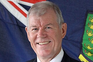
William Boyd McCleary is a retired member of HM Diplomatic Service originally from Belfast, Northern Ireland.
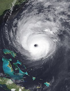
Hurricane Earl was the first major hurricane to threaten New England since Hurricane Bob in 1991. The fifth named storm of the season, Earl originated from a tropical wave to west of the Cape Verde Islands on August 25, 2010. Tracking nearly due west, the system attained tropical storm intensity within hours of genesis. After maintaining winds of 50 mph (85 km/h) for nearly two days, Earl began to strengthen as it neared the Lesser Antilles. The storm intensified into a hurricane on August 29 and later a major hurricane on August 30 as it brushed the Leeward Islands. A temporary weakening trend took place as Earl moved northwestward, contributed to moderate southwesterly wind shear, but intensification later resumed by September 1. Once reorganized, Earl reached its peak winds of 145 mph (230 km/h). Executing a gradual curve to the northeast, the hurricane slowly weakened over decreasing sea surface temperatures; the storm's center passed roughly 85 mi (140 km) east of Cape Hatteras, North Carolina on September 3. Accelerating northeastward, the system briefly weakened to a tropical storm before reattaining hurricane strength as it made landfall near Western Head, Nova Scotia. After traversing the peninsula, the hurricane became extratropical and was later absorbed by a larger low pressure area on September 6, while located north of Newfoundland.
This article is incomplete.(October 2017) |

The British Virgin Islands (BVI), officially simply the Virgin Islands, are a British Overseas Territory in the Caribbean, to the east of Puerto Rico. The islands are geographically part of the Virgin Islands archipelago and are located in the Leeward Islands of the Lesser Antilles.

The British Virgin Islands are located in the Caribbean, between the Caribbean Sea and the North Atlantic Ocean, east of Puerto Rico.Its geographic coordinates are 18°30′N 64°30′W. Map references include Central America and the Caribbean. The area totals 151 km² and comprises 16 inhabited and more than 20 uninhabited islands; includes the islands of Tortola, Anegada, Virgin Gorda and Jost van Dyke. There are no bodies of water on the land. There are no land boundaries. There is 80 km of coastline. Maritime claims include 3 nmi of territorial sea and exclusive a 200 nmi fishing zone. It has a tropical, humid climate, with temperatures moderated by trade winds. Its terrain consists of coral islands, and is relatively flat. It has volcanic islands and is steep and hilly. Its lowest point is the Caribbean Sea and its highest point is Mount Sage at 521 metres (1,709 ft) above sea level. Its natural resources are negligible. In terms of land use, it is 20% arable land, 6.67% permanent crops and 73.33% other as of a 2005 figure. Its natural hazards consist of hurricanes and tropical storms from July to October. There is limited natural fresh water resources. It has strong ties to nearby U.S. Virgin Islands and Puerto Rico.

The United States Virgin Islands, officially the Virgin Islands of the United States, is a group of islands in the Caribbean and an unincorporated and organized territory of the United States. The islands are geographically part of the Virgin Islands archipelago and are located in the Leeward Islands of the Lesser Antilles.

Geography of the United States Virgin Islands

The History of the British Virgin Islands is usually, for convenience, broken up into five separate periods:

Anegada is the northernmost of the British Virgin Islands (BVI), a group of islands that form part of the archipelago of the Virgin Islands. It lies approximately 15 miles (24 km) north of Virgin Gorda. Anegada is the only inhabited British Virgin Island formed from coral and limestone, rather than being of volcanic origin. While the other islands are mountainous, Anegada is flat and low. Its highest point is only about 28 feet (8.5 m) above sea level, earning it its name, which is the Spanish term for the flooded land, "tierra anegada".

Hurricane Marilyn was the most powerful hurricane to strike the Virgin Islands since Hurricane Hugo of 1989, and the third such tropical cyclone in roughly a two-week time span to strike or impact the Leeward Islands, the others being Hurricane Iris and the much more powerful and destructive Hurricane Luis. The thirteenth named storm, seventh hurricane and third major hurricane of the extremely active 1995 Atlantic hurricane season, Marilyn formed on September 12 as a tropical depression from a tropical wave that moved off the coast of Africa on September 7. After formation, the storm quickly became a tropical storm, and steadily intensified into a hurricane by the time it struck the Lesser Antilles on September 14 at Category 1 strength. Entering the northeastern Caribbean Sea, rapid intensification ensued and it peaked on September 16 north of Puerto Rico as a Category 3 hurricane shortly after it had impacted the U.S. Virgin Islands. A Hurricane Hunter reconnaissance flight reported hail, which is unusual for tropical cyclones. After heading north past Bermuda, Marilyn weakened and became extratropical on September 22. The remnant circulation wandered the Atlantic Ocean from September 23 – October 1, just south of Nova Scotia.

Saint John is one of the Virgin Islands in the Caribbean Sea and a constituent district of the United States Virgin Islands (USVI), an unincorporated territory of the United States.

Road Town, located on Tortola, is the capital of the British Virgin Islands. It is situated on the horseshoe-shaped Road Harbour in the centre of the island's south coast. The population was about 9,400 in 2004.
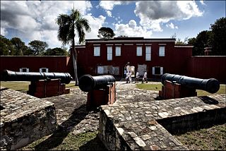
Frederiksted is both the town and one of the two administrative districts of St. Croix, U.S. Virgin Islands. It is a grid-planned city, designed by surveyor Jens Beckfor, originally to 14x14 blocks but built 7x7 to enhance the island commerce in the 1700s. Frederiksted has fewer than 1,000 people in the town proper, but nearly 10,000 in the greater western side of the island. Christiansted is about 30 years older but commerce was limited by its natural, shallow protective reef. Frederiksted was built in the leeward side of the island for calm seas and a naturally deep port. It is home to Fort Frederik, constructed to protect the town from pirate raids and attacks from rival imperialist nations and named after Frederick V of Denmark, who purchased the Danish West Indies in 1754.
Tortola is the largest and most populated of the British Virgin Islands, a group of islands that form part of the archipelago of the Virgin Islands. It has a surface area of 55.7 square kilometres with a total population of 23,908, with 9,400 residents in Road Town. Mount Sage is its highest point at 530 metres above sea level.

Necker Island is a 30-hectare (74-acre) island in the British Virgin Islands just north of Virgin Gorda. The island's land is entirely owned by Sir Richard Branson, chairman of the Virgin Group, and is part of the Virgin Limited Edition portfolio of luxury properties. The whole island operates as a resort and can accommodate up to 34 guests, with additional room for six children.

Eustatia Island is a 30-acre island of the British Virgin Islands (BVI) in the Caribbean. The word "Eustatia” is a Greek derived word meaning, “good place to stay.” The entire island, and a small neighboring island, Saba Rock, are under the same long term lease. The island is regularly featured and photographed for several publications and was listed as one to top 20 most beautiful islands in the world in the December 2004 issue of Islands magazine.

The 2010 Atlantic hurricane season was the first in a group of three very active Atlantic hurricane seasons. It is tied alongside 1887, 1995, 2011, and 2012 with 19 tropical storms, the third highest count in recorded history. It featured 12 hurricanes, tied with 1969 for the second highest total. Only the quintessential 2005 season saw more activity. The overall tropical cyclone count in the Atlantic exceeded that in the West Pacific for only the second time on record. The season officially began on June 1 and ended on November 30, dates that conventionally delimit the period during each year when tropical cyclone formation is most likely. The first cyclone, Alex intensified into the first June hurricane since Allison in 1995. The month of September featured eight named storms, tying 2002 and 2007 for the record. October featured five hurricanes, just short of the record set in 1870. Finally, Hurricane Tomas became the latest hurricane on record to move through the Windward Islands in late October. Activity was represented with an accumulated cyclone energy (ACE) value of 165 units, which was the eleventh highest value on record at the time.
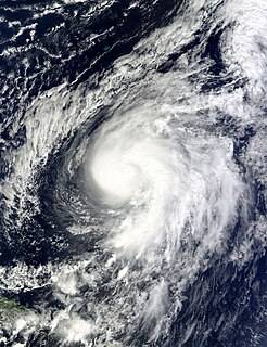
Hurricane Otto produced days of torrential rain over much of the northeastern Caribbean in October 2010. Otto originated as a subtropical cyclone lingering north of Puerto Rico on October 6, and transitioned into a tropical storm the next day, the fifteenth of the 2010 hurricane season. Accelerating toward the northeast, Otto strengthened into a Category 1 hurricane on the Saffir–Simpson scale on October 8, attaining peak winds of 85 mph (140 km/h). The storm began weakening due to incompatible surroundings and became extratropical west of the Azores on October 10. Otto was the first Atlantic tropical cyclone on record to transition from a subtropical storm since Tropical Storm Laura in 2008.

Sugar production in the United States Virgin Islands was an important part of the Economy of the United States Virgin Islands for over two hundred years. Long before the islands became part of the United States in 1917, the islands, particular the island of Saint Croix, was exploited by the Danish from the early 18th century and by 1800 over 30,000 acres were under cultivation, earning Saint Croix a reputation as "The Garden of the West Indies". Since the closing of the last sugar factory on Saint Croix in 1966, the industry has become only a memory.

Events from the year 2017 in the British Virgin Islands.