26th Street/Bergamot station

Last updated
26th St/Bergamot
LACMTA Circle E Line.svg  
MetroELineOlympicStation.jpg
E Line train at the station
General information
Location2425 Olympic Boulevard
Santa Monica, California
Coordinates 34°01′40″N118°28′12″W / 34.0279°N 118.4699°W / 34.0279; -118.4699
Owned by Los Angeles County Metropolitan Transportation Authority
Platforms2 side platforms
Tracks2
Connections Big Blue Bus
Construction
Bicycle facilities Racks and lockers [1]
AccessibleYes
History
OpenedOctober 17, 1875;148 years ago (October 17, 1875)
RebuiltMay 20, 2016;7 years ago (2016-05-20)
Previous names Bergamot
Services
Preceding station LAMetroLogo.svg Metro Rail Following station
17th Street/SMC E Line Expo/Bundy
Former services
Preceding station PE Bolt.svg Pacific Electric Following station
Sunset
towards Rustic Canyon
Air Line Bundy
Location
26th Street/Bergamot station

26th Street/Bergamot station is an at-grade light rail station in the Los Angeles Metro Rail system. It is located near the intersection of 26th Street and Olympic Boulevard in Santa Monica, California and near the Bergamot Station Arts Center. The station is served by the E Line. [2]

Contents

Service

Station layout

Side platform, doors will open on the right
Westbound LACMTA Circle E Line.svg E Line toward Downtown Santa Monica (17th Street/SMC)
Eastbound LACMTA Circle E Line.svg E Line toward East Los Angeles (Expo/Bundy)
Side platform, doors will open on the right

The station is in the Pico District of Santa Monica, along the southern edge of Olympic Boulevard, just east of 26th Street.

The City of Santa Monica refers to the station area as the "Bergamot Transit Village". [3] It is also within walking distance of several business offices and studios, including the Water Garden office complex, as well as several parks.

The station has entrances on both ends. [4]

Hours and frequency

E Line service hours are from approximately 4:30 a.m. and 11:45 p.m daily. Trains operate every 8 minutes during peak hours, Monday through Friday. During weekday midday and weekends from 9:00 a.m. to 7:00 p.m., trains run every 10 minutes. Night and early morning service is approximately every 20 minutes every day. [5]

Connections

As of December 10,2023, the following connections are available: [6] [7]

Notable places nearby

The station is within walking distance of the following notable places:

Name and history

Wild Bergamot (Monarda fistulosa) still grows in clumps around the station area. Monarda-fistulosa.jpg
Wild Bergamot (Monarda fistulosa) still grows in clumps around the station area.

The name "Bergamot Station" dates back to 1890, and was a stop and car storage area on the steam powered Los Angeles and Independence Railroad from Santa Monica to downtown Los Angeles, as well as the subsequent Santa Monica Air Line on the Pacific Electric trolley system until 1953. [8] [9]

Vehicle maintenance facility

Expo Phase 2 included a maintenance facility for Expo light-rail vehicles. This facility performs shop-related activities, including servicing, cleaning, inspecting, and repairing LRT vehicles. It also includes a yard with a storage capacity of up to 45 LRT vehicles. [4]

Several locations for this facility were proposed and evaluated, including the "Verizon site" (land just east of Bergamot Station, between Stewart Street and Centinela Avenue) and the Bergamot Station site. Many residents of the surrounding Stewart Park neighborhood opposed the use of the Verizon site, who feared the project would create noise and another environmental impact. The use of the Bergamot Station site was opposed by artists at Bergamot Station, who successfully argued that Bergamot had become an irreplaceable resource for the west coast art community. [10]

The City of Santa Monica and Expo built the facility on land which includes the Verizon site, as well as land that was a parking lot owned by Santa Monica College. They believe that with this "hybrid site", most environmental impacts from the facility were properly mitigated. [11] [12] [13]

Related Research Articles

<span class="mw-page-title-main">E Line (Los Angeles Metro)</span> Light rail line in Los Angeles County, California

The E Line is a 22-mile (35 km) light rail line in Los Angeles County, California. It is one of the six lines of the Los Angeles Metro Rail system, operated by the Los Angeles County Metropolitan Transportation Authority (Metro). The E Line runs east-west and serves 29 stations between East Los Angeles and Santa Monica. It interlines and shares five stations with the A Line in Downtown Los Angeles. Service operates for approximately 19 hours with headways of up to 8 minutes during peak hours. The E Line, the second-busiest light rail line in the system, saw an average of 41,902 passengers on weekdays in October 2023.

<span class="mw-page-title-main">Olympic Boulevard (Los Angeles)</span> Major arterial road in Los Angeles, California

Olympic Boulevard is a major arterial road in Los Angeles, California. It stretches from Ocean Avenue on the western end of Santa Monica to East Los Angeles—farther than Wilshire Boulevard and most other streets.

<span class="mw-page-title-main">Regional Connector</span> Transit project in Los Angeles

The Regional Connector Transit Project constructed a 1.9-mile (3.1 km) light rail tunnel for the Los Angeles Metro Rail system in Downtown Los Angeles. It connected the A and E lines with the former L Line. The A and E lines previously both terminated at 7th Street/Metro Center station, coming from Long Beach and Santa Monica, respectively, while the L Line ran through Little Tokyo/Arts District to either Azusa or East Los Angeles. Now the A and E lines continue together through new stations at Grand Avenue Arts/Bunker Hill, Historic Broadway, and Little Tokyo/Arts District. From there, they diverge on the former L Line toward Azusa and East Los Angeles, respectively. The project provides a one-seat ride into the core of Downtown for passengers on those lines who previously needed to transfer, thus reducing or altogether eliminating many transfers of passengers traveling across the region via Downtown Los Angeles.

<span class="mw-page-title-main">Bergamot (arts center)</span> Art gallery facility in Santa Monica, California, US

Bergamot Station Arts Center is a Santa Monica facility housing many different private art galleries and appears in most tourist guides as a primary cultural destination. Opened September 17, 1994 as Bergamot Station the campus-like complex is owned by the city of Santa Monica and presently managed by the Worthe Group.

<span class="mw-page-title-main">Expo Park/USC station</span> Los Angeles Metro Rail station

Expo Park/USC station is an at-grade light rail station on the E Line of the Los Angeles Metro Rail system. The station is located in the center median of Exposition Boulevard near entrances to Exposition Park and the University of Southern California (USC), after which the station is named. The 37th Street/USC station for the J Line of the Los Angeles Metro Busway system is located a few blocks east of the station.

<span class="mw-page-title-main">Expo/Vermont station</span> Los Angeles Metro Rail station

Expo/Vermont station is an at-grade light rail station on the E Line of the Los Angeles Metro Rail system. The station is located in the center median of Exposition Boulevard at its intersection with Vermont Avenue, after which the station is named, near the Exposition Park and West Adams neighborhoods of Los Angeles.

<span class="mw-page-title-main">Expo/Western station</span> Los Angeles Metro Rail station

Expo/Western station is an at-grade light rail station on the E Line of the Los Angeles Metro Rail system. The station is located in the center median of Exposition Boulevard at its intersection with Western Avenue, after which the station is named, in the West Adams neighborhood of Los Angeles.

<span class="mw-page-title-main">Expo/Crenshaw station</span> Los Angeles Metro Rail station

Expo/Crenshaw station is a light rail station in the Los Angeles Metro Rail system located in the Jefferson Park neighborhood of Los Angeles at the intersection of Crenshaw and Exposition Boulevards. During construction, it was known as the Crenshaw station. The station is the transfer point between the E Line, which stops at two street-level platforms alongside Exposition Boulevard, and the K Line, which has its northern terminus at a single island platform under Crenshaw Boulevard.

<span class="mw-page-title-main">Farmdale station</span> Los Angeles Metro Rail station

Farmdale station is an at-grade light rail station on the E Line of the Los Angeles Metro Rail system. The station is located in the center median of Exposition Boulevard at its intersection with Farmdale Avenue, after which the station is named, in the West Adams neighborhood of Los Angeles. It is located between Expo/La Brea station to the west and Expo/Crenshaw station to the east.

<span class="mw-page-title-main">La Cienega/Jefferson station</span> Los Angeles Metro station

La Cienega/Jefferson station is an elevated light rail station on the E Line of the Los Angeles Metro Rail system. The station is over the intersection of La Cienega Boulevard and Jefferson Boulevard, after which the station is named, in the Baldwin Hills neighborhood of Los Angeles.

<span class="mw-page-title-main">Culver City station</span> Los Angeles Metro Rail station

Culver City station is an elevated light rail station on the E Line of the Los Angeles Metro Rail system. The station is located on a dedicated right-of-way alongside Exposition Boulevard — between the intersection of Venice Boulevard and Robertson Boulevard on the west and the intersection of Washington Boulevard and National Boulevard on the east. The station is located in the city of Culver City, California, after which the station is named.

<span class="mw-page-title-main">Palms station</span> Los Angeles Metro Rail station

Palms station is an elevated light rail station on the E Line of the Los Angeles Metro Rail system. The station is located over the intersection of National Boulevard and Palms Boulevard in the Palms neighborhood of Los Angeles, after which the station is named.

<span class="mw-page-title-main">Westwood/Rancho Park station</span> Los Angeles Metro Rail station

Westwood/Rancho Park station is an at-grade light rail station in the Los Angeles Metro Rail system located at the intersection of Westwood Boulevard and Exposition Boulevard in the Rancho Park neighborhood of West Los Angeles, California. It serves the E Line. The station connects to the UCLA campus via the Big Blue Bus Rapid 12 and Route 8 lines.

<span class="mw-page-title-main">Expo/Sepulveda station</span> Los Angeles Metro Rail station

Expo/Sepulveda station is an elevated light rail station in Los Angeles. It serves the E Line. The station connects to the UCLA campus via the Culver CityBus 6 and Rapid 6 and Metro 761 bus lines.

<span class="mw-page-title-main">Expo/Bundy station</span> Los Angeles Metro Rail station

Expo/Bundy station is an elevated light rail station in the Los Angeles Metro Rail system. It is located at the intersection of Bundy Drive and Exposition Boulevard in West Los Angeles, California. It serves the Metro E Line.

<span class="mw-page-title-main">17th Street/SMC station</span> Light rail station

17th Street/SMC station is an at-grade light rail station in the Los Angeles Metro Rail system located near the intersection of 17th Street and Colorado Avenue in Santa Monica, California. It is served by the E Line.

<span class="mw-page-title-main">Downtown Santa Monica station</span> Los Angeles Metro Rail station

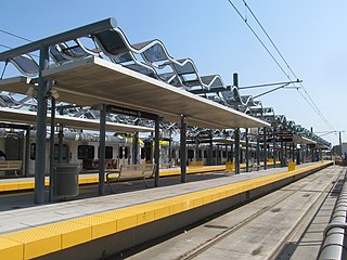
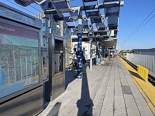
Downtown Santa Monica station is an at-grade light rail station in the Los Angeles Metro Rail system. It is located near the intersection of 4th Street and Colorado Avenue in downtown Santa Monica, California. It is the E Line's western terminal station.

<span class="mw-page-title-main">K Line Northern Extension</span> Planned light rail extension project in Los Angeles, California

The K Line Northern Extension Project, formerly known as the Crenshaw Northern Extension Project, is a project planning a Los Angeles Metro Rail light rail transit corridor extension connecting Expo/Crenshaw station to Hollywood/Highland station in Hollywood. The corridor is a fully underground, north-south route along mostly densely populated areas on the western side of the Los Angeles Basin; it would be operated as part of the K Line. The Los Angeles County Metropolitan Transportation Authority (Metro) is prioritizing the project along with pressure from the West Hollywood residents. Construction is slated to start in 2041 and begin service by 2047 unless means to accelerate the project are found.

The history of the Los Angeles Metro Rail and Busway system begins in the early 1970s, when the traffic-choked region began planning a rapid transit system. The first dedicated busway opened along I-10 in 1973, and the region's first light rail line, the Blue Line opened in 1990. Today the system includes over 160 miles (260 km) of heavy rail, light rail, and bus rapid transit lines, with multiple new lines under construction as of 2019.

<span class="mw-page-title-main">Expo Bike Path</span> Rail with trail bicycle path in Los Angeles County, California

The Expo Bike Path is a 12-mile-long (19 km) rail with trail bicycle path and pedestrian route in Los Angeles County, California that travels roughly parallel to the Los Angeles Metro Rail's E Line between La Cienega/Jefferson and 17th Street/SMC stations. The Expo Bike Path is one of two major bicycle routes in Los Angeles that share dedicated rights-of-way with public transport, the other being the G Line Bikeway in the San Fernando Valley.

References

  1. "Secure Bike Parking on Metro" (PDF). Los Angeles County Metropolitan Transportation Authority. Archived from the original (PDF) on September 6, 2021. Retrieved November 5, 2021.
  2. ".:: Expo Line::". Archived from the original on August 12, 2011. Retrieved March 31, 2011.
  3. "2010 Land Use and Circulation Element (LUCE) – Planning & Community Development – City of Santa Monica". Shapethefuture2025.net. Archived from the original on March 5, 2012. Retrieved May 24, 2016.
  4. 1 2 "Archived copy" (PDF). Archived from the original (PDF) on July 25, 2011. Retrieved March 31, 2011.{{cite web}}: CS1 maint: archived copy as title (link)
  5. "Metro E Line schedule". Los Angeles County Metropolitan Transportation Authority. December 10, 2023. Retrieved December 25, 2023.
  6. "E Line Timetable – Connections section" (PDF). Los Angeles County Metropolitan Transportation Authority . December 10, 2023. p. 1. Retrieved December 26, 2023.
  7. "Little Blue Book" (PDF). Big Blue Bus (Santa Monica). December 17, 2023. Retrieved December 26, 2023.
  8. "Bergamot Station". Bergamot Station. April 30, 2016. Archived from the original on September 3, 2011. Retrieved May 24, 2016.
  9. "Los Angeles Herald. "The Iron Highways." June 14, 1890. page 2". Archived from the original on August 15, 2016. Retrieved July 24, 2016.
  10. "The Argonaut: Top Stories". Archived from the original on July 23, 2012. Retrieved April 16, 2010.
  11. "Exposition Light Rail Phase 2 Maintenance Facility Update - City of Santa Monica". Archived from the original on July 23, 2011. Retrieved April 14, 2010.
  12. "Archived copy" (PDF). Archived from the original (PDF) on July 23, 2011. Retrieved April 16, 2010.{{cite web}}: CS1 maint: archived copy as title (link)
  13. Boehm, Mike (June 14, 2014) "Bergamot Station's tenants at odds over its future as Expo Line nears" Archived 2014-06-16 at the Wayback Machine Los Angeles Times