33 Ashbury/18th Street

Last updated

33 Ashbury/18th Street
Muni worm logo.svg
Muni route 33 trolleybus at Collingwood Street, January 2021.jpg
33-Ashbury/18th Street trolleybus on 18th Street in 2021
Overview
System Muni trolleybus network
Operator San Francisco Municipal Railway
Statusoperational
Began service1892 (1892) (streetcar)
October 6, 1935 (October 6, 1935) (trolleybus)
Predecessors33 18th and Park
Route
Locale San Francisco, California
StartSacramento and Cherry
End25th Street and Potrero
Length6.6 miles (10.6 km)
Service
Frequency15 minutes
Weekend frequency20 minutes
Daily ridership5,700 (2019) [1]
Map 33 Ashbury/18th Street
  31 Balboa   List of San Francisco Municipal Railway lines   35 Eureka  

33 Ashbury/18th Street is a trolleybus line operated by the San Francisco Municipal Railway. The route is descendant from the first trolleybus service to open in San Francisco.

Route description

From 25th Street and Potrero, [2] buses loop north to run on Potrero to 16th Street. After turning west on 16th, the line runs past 16th Street Mission BART station. It briefly runs south on Mission Street until 18th Street. After 18th merges into Market Street, buses continue until a sharp turn onto Clayton. [2] At the corner of Haight and Ashbury, the route turns onto Haight Street and runs until Golden Gate Park, where it takes a left onto Stanyan. [2] It doglegs onto Arguello via Stanyan Street and continues north until it loops to its terminus at 25th Street and Potrero, adjacent to the California Pacific Medical Center California Campus. [3]

History

Streetcar line

An electric streetcar line had been promoted as a key feature of the development of the Clarendon Heights neighborhood in the early 1890s. [4] The 33 Line was established in 1892 by the San Francisco and San Mateo Railway Company as the 18th and Park or 18th Street Branch route. That route initially ran along 18th from Guerrero to Douglass before being extended to Frederick and Ashbury including a sharp switchback [5] [6] on the lower slopes of Twin Peaks at Market and Clayton by May 1894. [7] The line was blocked from continuing to Golden Gate Park because the Market Street Railway Company had their line on Frederick Street, denying the SF&SM any further access. [7] Cars on the line were specially equipped with transverse seating so riders would not change orientation when negotiating the junction. [5]

Trolleybus operation

A trolleybus navigating the sharp curve at Market and Clayton Muni route 33 trolleybus on outer curve at Market and Clayton (1), July 2022.JPG
A trolleybus navigating the sharp curve at Market and Clayton

In April 1934, Col. Jno H. Skeggs of the State Highway Department urged the conversion of the 33 streetcar to "trackless trolley", [8] as some of its tracks would have to be taken up for the construction of the Bay Bridge. By early August of that year, the Market Street Railway Company (MSRy), eventual successor to the San Francisco and San Mateo, applied to the State Railroad Commission for permission to build and operate a trackless trolley system. [9] [lower-alpha 1] Permission was granted by August 30, [12] and the first trolleybus service started on October 6, 1935, using 9 coaches built by the J. G. Brill Company. [13] At the time of conversion, the 33 streetcar had operated between Third & Harrison (Downtown) and Waller & Stanyan (Golden Gate Park), [9] a round trip of 10.2 miles (16.4 km). The San Francisco Municipal Railway acquired the company's assets in 1944 and began operating the line. [14]

Operations were moved to the Potrero division after the Haight Barn suffered structural failure in 1946. [5] Service on Potrero Street to San Francisco General Hospital began on August 24, 1983. [15] The south end of this extension was at Army Street (now César Chávez Street), [16] and its opening brought into use a newly built section of overhead wires south of 25th Street. [17] The overhead wires along Potrero Street north of 25th Street had already existed for several years and been in use by route 47, which was a trolleybus route at that time (and which continued to terminate at 25th Street after the August 1983 changes). [17]

At its opposite end, route 33 was extended from Haight to Sacramento Street on February 6, 1988, [18] and renamed from 33 Ashbury to 33 Stanyan. [19] On December 21, 1988, service at the route's southern end was cut back from Army Street to 25th Street. [20] The approximately 2,000 feet (610 m) of wires that had opened for use in 1983 remained usable in the mid-2010s and had occasionally been used for temporary diversions necessitated by construction on 25th. [21]

Twenty-seven years after its last name change, in April 2015, route 33 was renamed again, to its current name of 33 Ashbury/18th Street. [22] [23] Service was temporarily suspended for parts of 2020 and 2021 amid the COVID-19 pandemic, [24] resuming on January 23, 2021. [25]

Notes

  1. At least one source, the Oakland Tribune, reported that this would be the first trackless trolley (trolleybus) system in California, but that was incorrect, as a commercial trolleybus system had operated in Laurel Canyon, Los Angeles, from 1910 to 1915. [10] [11]

Related Research Articles

<span class="mw-page-title-main">San Francisco Municipal Railway</span> Public transport agency in San Francisco, California, USA

The San Francisco Municipal Railway (SF Muni or Muni), is the public transit system for the City and County of San Francisco. It operates a system of bus routes, the Muni Metro light rail system, three historic cable car lines, and two historic streetcar lines. Previously an independent agency, the San Francisco Municipal Railway merged with two other agencies in 1999 to become the San Francisco Municipal Transportation Agency (SFMTA). In 2018, Muni served 46.7 square miles (121 km2) with an operating budget of about $1.2 billion. Muni is the seventh-highest-ridership transit system in the United States, with 114,721,200 rides in 2022, and the second-highest in California after the Los Angeles County Metropolitan Transportation Authority.

<span class="mw-page-title-main">Hamilton Street Railway</span> Public transit agency in Ontario, Canada

The Hamilton Street Railway commonly known as the HSR is a public transport agency in Hamilton, Ontario, Canada. The name is a legacy of the company's early period, when public transit in Hamilton was primarily served by streetcars. Although streetcars are no longer used in the city today, the HSR operates bus and paratransit services, with a ridership of 21 million passengers a year. The HSR uses the Presto card as its method of fare payment, allowing for connections with GO Transit and other transit systems in the Greater Toronto area.

<span class="mw-page-title-main">Trolleybuses in Greater Boston</span> Electric powered public transportation

The Boston-area trolleybussystem forms part of the public transportation network serving Greater Boston in the U.S. state of Massachusetts. It opened on April 11, 1936, and since 1964 has been operated by the Massachusetts Bay Transportation Authority (MBTA). The current system consists of the Silver Line (Waterfront), a 2004-opened bus rapid transit line using dual-mode buses which run as trolleybuses in a tunnel in the Seaport District of Boston before switching to diesel power to serve other destinations.

<span class="mw-page-title-main">Van Ness Bus Rapid Transit</span> Bus rapid transit corridor in San Francisco

Van Ness Bus Rapid Transit is a bus rapid transit (BRT) corridor on Van Ness Avenue in San Francisco, California, United States. The 1.96-mile (3.15 km) line, which runs between Mission Street and Lombard Street, has dedicated center bus lanes and nine stations. It was built as part of the $346 million Van Ness Improvement Project, which also included utility replacement and pedestrian safety features. Van Ness Bus Rapid Transit is used by several San Francisco Municipal Railway (Muni) lines including the 49 Van Ness–Mission, as well as three Golden Gate Transit routes.

<span class="mw-page-title-main">San Francisco Municipal Railway fleet</span> LRV and Bus Fleet of the San Francisco Municipal Railway (Muni)

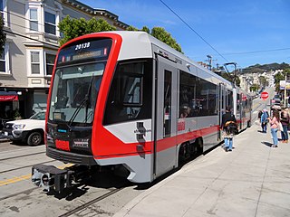
With five different modes of transport the San Francisco Municipal Railway runs one of the most diverse fleets of vehicles in the United States. Roughly 550 diesel-electric hybrid buses, 300 electric trolleybuses, 250 modern light rail vehicles, 50 historic streetcars and 40 cable cars see active duty.

SEPTA Route 79 is a former trackless trolley and current bus route, operated by the Southeastern Pennsylvania Transportation Authority (SEPTA) in South Philadelphia, Pennsylvania, United States. The line runs between the Point Breeze neighborhood and the vicinity of Pier 70 along the Delaware River. Trackless trolleys replaced buses in 1961 but were suspended in 2003, and the authority later decided against restoring trackless trolley service. Trolley cars had previously served Route 79 from 1912 until 1956.

<span class="mw-page-title-main">SEPTA Route 29</span> Bus route in South Philadelphia

SEPTA Route 29 is a former streetcar and trackless trolley line and current bus route, operated by the Southeastern Pennsylvania Transportation Authority (SEPTA) in South Philadelphia, Pennsylvania, United States. The line runs between the Gray's Ferry neighborhood and the vicinity of Pier 70 along the Delaware River.

<span class="mw-page-title-main">Broad and Plymouth station</span> Light rail stop in San Francisco, California, U.S.

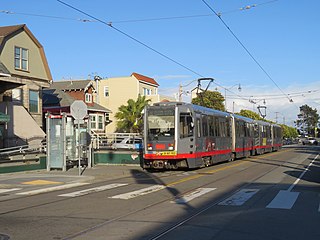
Broad and Plymouth station is a light rail stop on the Muni Metro M Ocean View line, located in the Ingleside neighborhood of San Francisco, California. The station has transit bulbs which extend the sidewalk of Broad Street, to meet trains like a side platform, allowing passengers to board or depart from trains. The stops are located just before trains cross Plymouth Avenue and include mini-high platforms which provide access to people with disabilities.

<span class="mw-page-title-main">Trolleybuses in San Francisco</span>

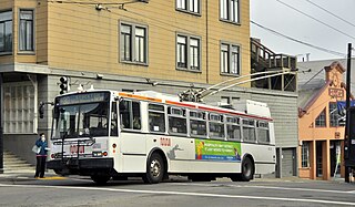
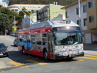
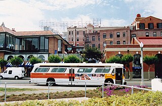
The San Francisco trolleybus system forms part of the public transportation network serving San Francisco, in the state of California, United States. Opened on October 6, 1935, it presently comprises 15 lines, and is operated by the San Francisco Municipal Railway, commonly known as Muni, with around 300 trolleybuses. In San Francisco, these vehicles are also known as "trolley coaches", a term that was the most common name for trolleybuses in the United States in the middle decades of the 20th century. In 2022, the system had a ridership of 33,664,000, or about 108,200 per weekday as of the fourth quarter of 2022.

<span class="mw-page-title-main">30 Stockton</span> Trolleybus route in San Francisco, California

30 Stockton is a trolleybus line operated by the San Francisco Municipal Railway. The line is notable for being the slowest trolleybus route in the city of San Francisco because it travels through the densely populated neighborhood of Chinatown.

<span class="mw-page-title-main">14 Mission</span> San Francisco trolleybus route

14 Mission is a trolleybus line operated by the San Francisco Municipal Railway. It serves Mission Street between the Ferry Plaza and Daly City.

<span class="mw-page-title-main">5 Fulton</span>

5 Fulton is a trolleybus line operated by the San Francisco Municipal Railway (Muni). It is one of several routes which connects the Outer Sunset to the Financial District.

<span class="mw-page-title-main">22 Fillmore</span>

22 Fillmore is a trolleybus line operated by the San Francisco Municipal Railway (Muni). It connects the Marina District to the Dogpatch in San Francisco.

<span class="mw-page-title-main">6 Haight/Parnassus</span> Trolleybus line in San Francisco, CA, US

6 Haight/Parnassus is a trolleybus line operated by the San Francisco Municipal Railway (Muni). It connects the Financial District to the Inner Sunset and Forest Hill via Haight-Ashbury.

<span class="mw-page-title-main">7 Haight/Noriega</span>

7 Haight/Noriega is a bus route operated by the San Francisco Municipal Railway (Muni). It connects the central business district to the Outer Sunset via Haight-Ashbury.

<span class="mw-page-title-main">31 Balboa</span> Trolleybus line operated by the San Francisco Municipal Railway

31 Balboa is a trolleybus line operated by the San Francisco Municipal Railway. It is one of several routes operating between the Financial District and the Richmond District.

<span class="mw-page-title-main">19 Polk</span>

19 Polk is a bus route operated by the San Francisco Municipal Railway (Muni). It runs from Ghirardelli Square in the north to Hunters Point in the south via Russian Hill, Nob Hill, the Tenderloin, South of Market, India Basin, and Potrero Hill.

<span class="mw-page-title-main">21 Hayes</span>

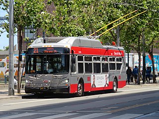
21 Hayes is a trolleybus line operated by the San Francisco Municipal Railway (Muni). It connects the Civic Center to the neighborhoods northeast of Golden Gate Park in San Francisco.

References

  1. "Short Range Transit Plan" (PDF). San Francisco Municipal Transportation Agency. December 3, 2019. Archived (PDF) from the original on June 5, 2020. Retrieved December 27, 2021.
  2. 1 2 3 Keeling, Brock (September 18, 2017). "The 33: San Francisco's most beautiful bus ride". Curbed San Francisco. Retrieved January 15, 2022.
  3. Wenus, Laura (November 2, 2015). "SFMTA Puts Bus Reroute On Hold to Weigh Concerns". Mission Local. Retrieved January 14, 2022.
  4. "Want A Railroad". San Francisco Chronicle . August 7, 1892. Retrieved February 5, 2022 via Newspapers.com. Lock-green.svg
  5. 1 2 3 Vielbaum et al. 2005 , pp. 86–87
  6. Callwell 1999 , p. 90
  7. 1 2 Rice, Walter; Echeverria, Emiliano. "San Francisco's pioneer electric railway: San Francisco & San Mateo Railway Company". SF Museum. Retrieved February 4, 2019.
  8. "Trackless Trolley Line Urged in S. F." Oakland Tribune . April 19, 1934. Retrieved February 6, 2019.
  9. 1 2 "Bus Trolleys May Run in S. F." Oakland Tribune. August 5, 1934. Retrieved February 6, 2019.
  10. Sebree, Mac; Ward, Paul (1973). Transit's Stepchild: The Trolley Coach. Los Angeles: Interurbans. LCCN   73084356.
  11. Murray 2000, p. 79
  12. "Trackless Trolleys to Operate in S. F." Oakland Tribune. August 30, 1934. Retrieved February 6, 2019.
  13. Callwell 1999 , pp. 40, 44
  14. Callwell 1999 , p. 44
  15. Mitchell, Dave (August 17, 1983). "Muni to test-drive 16 routes — 3rd big change since 1979". San Francisco Examiner. p. 14. Retrieved February 17, 2022 via Newspapers.com. Lock-green.svg
  16. Jewell, Don (February 1984). "Muni [regular news column]". Pacific RailNews . Interurban Press. pp. 30–31. ISSN   8750-8486.
  17. 1 2 Trolley Coach News No. 60 (Spring/Summer 1985), pp. 160–162. North American Trackless Trolley Association. LCCN   84-648480
  18. Callwell 1999 , pp. 66–67
  19. Trolleybus Magazine No. 159 (May–June 1988), p. 67. National Trolleybus Association (UK). ISSN   0266-7452
  20. Trolleybus Magazine No. 166 (July–August 1989), p. 99. National Trolleybus Association (UK). ISSN   0266-7452
  21. Trolleybus Magazine No. 320 (March–April 2015), p. 63. National Trolleybus Association (UK). ISSN   0266-7452
  22. Trolleybus Magazine No. 322 (July–August 2015), p. 126. National Trolleybus Association (UK). ISSN   0266-7452
  23. Avery, Camden (March 25, 2015). "71-Haight/Noriega Muni Line To Rebrand As Revived 7 Line". Hoodline. Retrieved January 22, 2022.
  24. "SFMTA expands service, access for equity neighborhoods in January". Mass Transit. January 21, 2021. Retrieved January 14, 2022.
  25. Trolleybus Magazine No. 356 (March–April 2021), p. 77. National Trolleybus Association (UK). ISSN   0266-7452

Bibliography

Template:Attached KML/33 Ashbury/18th Street
KML is not from Wikidata