Related Research Articles
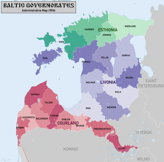
The Baltic governorates, originally the Ostsee governorates, was a collective name for the administrative units of the Russian Empire set up in the territories of Swedish Estonia, Swedish Livonia (1721) and, afterwards, of the Duchy of Courland and Semigallia (1795).

The modern administrative-territorial structure of Russia is a system of territorial organization which is a product of a centuries-long evolution and reforms.
This is a summary of the administrative divisions of Russia from 1714-1717.
This is a summary of the administrative divisions of Russia from 1717-1719.

Smolensk Governorate, or the Government of Smolensk, was an administrative division of the Tsardom of Russia, the Russian Empire, and the Russian SFSR. It existed, with interruptions, between 1708 and 1929.
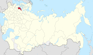
The Saint Petersburg Governorate was a governorate of the Russian Empire, with its administrative centre in Saint Petersburg. The governorate was composed of 44,613 square kilometres (17,225 sq mi) of area and 2,112,033 inhabitants. The Saint Petersburg Governorate was bordered by the Estonian and Livonian Governorates to the west, the Pskov Governorate to the south, the Novgorod Governorate to the east, the Olonets Governorate to the northeast, and the Vyborg Governorate of the Grand Duchy of Finland to the north. The governorate covered most of the areas of modern Leningrad Oblast and Ida-Viru, Jõgeva, Tartu, Põlva, and Võru counties of Estonia.

Demidov is a town and the administrative center of Demidovsky District in Smolensk Oblast, Russia, located on the Kasplya River at its confluence with the Gobza River. Population: 7,333 (2010 Census); 8,786 (2002 Census); 10,198 (1989 Census). It was previously known as Porechye.
Riga Governorate, also known as the Province of Riga, was an administrative division of the Russian Empire in modern southern Estonia and northern Latvia from 1713 to 1783. The Province of Riga was formed to replace the Eastern Provinces of the Kingdom of Sweden in 1713. After the conquest of the regions of Ingermanland, Livonia and Estonia by Sweden in the Great Northern War in 1710. In 1713, the Provinces of Riga and Tallinn were separated into separate administrative units, and in 1713–1714, the organization and management of the Province of Riga were also defined.
Revel Governorate, also known as Tallinn Governorate, was an administrative division of the Russian Empire from 1719 to 1783.
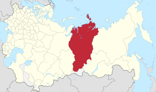
Yeniseysk Governorate was a governorate (guberniya) of the Russian Empire and later of the Russian Republic, Russian Socialist Federative Soviet Republic in 1822-1925.

Demidovsky District is an administrative and municipal district (raion), one of the twenty-five in Smolensk Oblast, Russia. It is located in the northwest of the oblast and borders with Zharkovsky District of Tver Oblast in the north, Velizhsky District in the northwest, Rudnyansky District in the southwest, Smolensky District in the south, and with Dukhovshchinsky District in the east. The area of the district is 2,514.02 square kilometers (970.67 sq mi). Its administrative center is the town of Demidov. Population: 14,039 ; 18,167 (2002 Census); 24,237 (1989 Census). The population of Demidov accounts for 52.2% of the district's total population.

References
- ↑ "Губернские реформы Петра I" (in Russian). Vladimir Oblast Research Library.