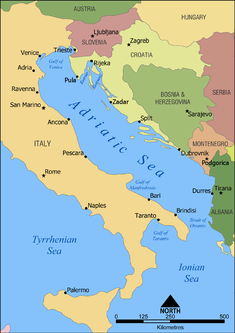
The Geography of Croatia is defined by its location—it is described as a part of Central Europe and Southeast Europe, a part of the Balkans and Mitteleuropa. Croatia's territory covers 56,594 km2 (21,851 sq mi), making it the 127th largest country in the world. Bordered by Bosnia and Herzegovina and Serbia in the east, Slovenia in the west, Hungary in the north and Montenegro and the Adriatic Sea in the south, it lies mostly between latitudes 42° and 47° N and longitudes 13° and 20° E. Croatia's territorial waters encompass 18,981 square kilometres (7,329 sq mi) in a 12 nautical miles wide zone, and its internal waters located within the baseline cover an additional 12,498 square kilometres (4,826 sq mi).

Albania is a small country in Southern and Southeastern Europe strategically positioned on the Adriatic and Ionian Sea inside the Mediterranean Sea, with a coastline of about 476 km (296 mi). It is bounded by Montenegro to the northwest, Kosovo to the northeast, North Macedonia to the east and Greece to the southeast and south.
Italy is located in southern Europe and comprises the long, boot-shaped Italian Peninsula, the southern side of Alps, the large plain of the Po Valley and some islands including Sicily and Sardinia. Corsica, although belonging to the Italian geographical region, has been a part of France since 1769. Italy is part of the Northern Hemisphere.
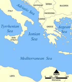
The Ionian Sea is an elongated bay of the Mediterranean Sea, south of the Adriatic Sea. It is bounded by Southern Italy including Calabria, Sicily, and the Salento peninsula to the west, southern Albania to the north, and the west coast of Greece.

Marche, or the Marches, is one of the twenty regions of Italy. The name of the region derives from the plural name of marca, originally referring to the medieval March of Ancona and nearby marches of Camerino and Fermo. Marche is well known for its shoemaking tradition, with the finest and most luxurious Italian footwear being manufactured in this region.

The Gulf of Corinth or the Corinthian Gulf is a deep inlet of the Ionian Sea, separating the Peloponnese from western mainland Greece. It is bounded in the east by the Isthmus of Corinth which includes the shipping-designed Corinth Canal and in the west by the Strait of Rion which widens into the shorter Gulf of Patras and of which the narrowest point is crossed since 2004 by the Rio–Antirrio bridge. The gulf is bordered by the large administrative divisions : Aetolia-Acarnania and Phocis in the north, Boeotia in the northeast, Attica in the east, Corinthia in the southeast and south and Achaea in the southwest. The gulf is in tectonic movement comparable to movement in parts of Iceland and Turkey, growing by 10 mm (0.39 in) per year.

Alvinocarididae is a family of shrimp, originally described by M. L. Christoffersen in 1986 from samples collected by DSV Alvin, from which they derive their name. Shrimp of the family Alvinocarididae generally inhabit deep sea hydrothermal vent regions, and hydrocarbon cold seep environments. Carotenoid pigment has been found in their bodies. The family Alvinocarididae comprises 7 extant genera.
Liburnia in ancient geography was the land of the Liburnians, a region along the northeastern Adriatic coast in Europe, in modern Croatia, whose borders shifted according to the extent of the Liburnian dominance at a given time between 11th and 1st century BC. Domination of the Liburnian thalassocracy in the Adriatic Sea was confirmed by several Antique writers, but the archeologists have defined a region of their material culture more precisely in northern Dalmatia, Kvarner and eastern Istria.

A blue hole is a large marine cavern or sinkhole, which is open to the surface and has developed in a bank or island composed of a carbonate bedrock. Blue holes typically contain tidally influenced water of fresh, marine, or mixed chemistry. They extend below sea level for most of their depth and may provide access to submerged cave passages. Well-known examples can be found in South China Sea, Belize, the Bahamas, Guam, Australia, and Egypt.

The Bothnian Bay or Bay of Bothnia is the northernmost part of the Gulf of Bothnia, which is in turn the northern part of the Baltic Sea. The land holding the bay is still rising after the weight of ice-age glaciers has been removed, and within 2,000 years the bay will be a large freshwater lake. The bay today is fed by several large rivers, and is relatively unaffected by tides, so has low salinity. It freezes each year for up to six months. Compared to other parts of the Baltic it has little plant or animal life.

Croatian Littoral is a historical name littoral for the region of Croatia comprising mostly Kvarner coastal area between traditional Dalmatia to the south, Mountainous Croatia to the north and east, and Istria and the Kvarner Gulf of the Adriatic Sea to the west. The term "Croatian Littoral" developed relatively recently, since the 18th and 19th centuries, reflecting the complex development of Croatia in historical and geographical terms. The term Croatian Littoral is also applied to entire Adriatic coast of modern Croatia in general terms, which is then divided into the Southern Croatian Littoral comprising Dalmatia, and the Northern Croatian Littoral comprising Istria and Croatian Littoral in the strict meaning of the term. Croatian Littoral covers 2,830 square kilometres and has a population of 228,725. More than half the region's population lives in the city of Rijeka—by far the largest urban centre in the area.

The Reno is a river of Emilia-Romagna, northern Italy. It is the tenth longest river in Italy and the most important of the region apart from the Po.

The Karaburun-Sazan Marine Park is a marine park in the Vlorë County of Southwestern Albania. The marine park encompasses over 125.70 km2 (48.53 sq mi) and comprise the boundaries of both the Peninsula of Karaburun and Island of Sazan. It is home to a vast array of landforms as for instance mountains, caves, islands, depressions, bays, cliffs, canyons and rocky coasts which in turn contribute to an exceptionally rich biological diversity. The marine park has been identified as an Important Bird and Plant Area, because it supports great bird and plant species. Containing ecosystems and habitats that are specific to the Mediterranean Basin, the convention of Barcelona has classified the marine park as a Specially Protected Areas of Mediterranean Importance.

Jiaolong is a Chinese manned deep-sea research submersible that can dive to a depth of over 7,000 metres (23,000 ft). It has the second-greatest depth range of any manned research vehicle in the world; the only manned expeditions to have gone deeper were the dives of the Trieste bathyscaphe in 1960, Archimède in 1962, Deepsea Challenger in 2012 and the Limiting Factor in December 2018 to the bottom of the Puerto Rico Trench.
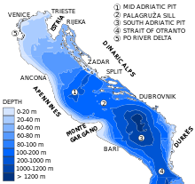
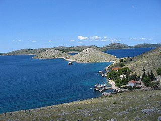
Topography of Croatia is defined through three major geomorphological parts of the country. Those are the Pannonian Basin, the Dinaric Alps, and the Adriatic Basin. The largest part of Croatia consists of lowlands, with elevations of less than 200 metres above sea level recorded in 53.42% of the country. Bulk of the lowlands are found in the northern regions of the country, especially in Slavonia, itself a part of the Pannonian Basin plain. The plains are interspersed by the horst and graben structures, believed to break the Pannonian Sea surface as islands. The greatest concentration of ground at relatively high elevations is found in Lika and Gorski Kotar areas in the Dinaric Alps, but such areas are found in all regions of Croatia to some extent. The Dinaric Alps contain the highest mountain in Croatia—1,831-metre (6,007 ft) Dinara, as well as all other mountains in Croatia higher than 1,500 metres. Croatia's Adriatic Sea mainland coast is 1,777.3 kilometres long, while its 1,246 islands and islets encompass further 4,058 kilometres of coastline—the most indented coastline in the Mediterranean. Karst topography makes up about half of Croatia and is especially prominent in the Dinaric Alps, as well as throughout the coastal areas and the islands.

The Ombla is a short river in Croatia, northeast of Dubrovnik. Its course is approximately 30 metres long, and it empties into the Rijeka Dubrovačka embayment of the Adriatic Sea near Komolac in Dubrovnik-Neretva County. Rijeka Dubrovačka is actually a ria, a flooded river valley formed through changes in sea surface elevation on a geologic time scale. The river rises as a karst spring fed by groundwater replenished by Trebišnjica, which is an influent stream flowing in Popovo Polje, in the immediate hinterland of the Ombla. The elevation difference between the river's source and its mouth is just over 2 metres. The average discharge of the river is 24.1 cubic metres per second. The drainage basin of the Ombla encompasses 600 square kilometres and, besides the short surface course, includes only groundwater flow.
Katina is an uninhabited Croatian island in the Adriatic Sea located between Dugi Otok to the north and Kornat to the south. Its area is 1.17 km2 (0.45 sq mi).

The Po is a river that flows eastward across northern Italy. The Po flows either 652 km (405 mi) or 682 km (424 mi) – considering the length of the Maira, a right bank tributary. The headwaters of the Po are a spring seeping from a stony hillside at Pian del Re, a flat place at the head of the Val Po under the northwest face of Monviso. The Po ends at a delta projecting into the Adriatic Sea near Venice. It has a drainage area of 74,000 km² in all, 70,000 in Italy, of which 41,000 is in montane environments and 29,000 on the plain. The Po is the longest river in Italy; at its widest point its width is 503 m (1,650 ft). The Po extends along the 45th parallel north.