
A geographic information system (GIS) consists of integrated computer hardware and software that store, manage, analyze, edit, output, and visualize geographic data. Much of this often happens within a spatial database, however, this is not essential to meet the definition of a GIS. In a broader sense, one may consider such a system also to include human users and support staff, procedures and workflows, the body of knowledge of relevant concepts and methods, and institutional organizations.
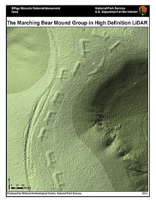
Lidar is a method for determining ranges by targeting an object or a surface with a laser and measuring the time for the reflected light to return to the receiver. LIDAR may operate in a fixed direction or it may scan multiple directions, in which case it is known as LIDAR scanning or 3D laser scanning, a special combination of 3-D scanning and laser scanning. LIDAR has terrestrial, airborne, and mobile applications.

A digital elevation model (DEM) or digital surface model (DSM) is a 3D computer graphics representation of elevation data to represent terrain or overlaying objects, commonly of a planet, moon, or asteroid. A "global DEM" refers to a discrete global grid. DEMs are used often in geographic information systems (GIS), and are the most common basis for digitally produced relief maps. A digital terrain model (DTM) represents specifically the ground surface while DEM and DSM may represent tree top canopy or building roofs.

Topography is the study of the forms and features of land surfaces. The topography of an area may refer to the land forms and features themselves, or a description or depiction in maps.

Remote sensing is the acquisition of information about an object or phenomenon without making physical contact with the object, in contrast to in situ or on-site observation. The term is applied especially to acquiring information about Earth and other planets. Remote sensing is used in numerous fields, including geophysics, geography, land surveying and most Earth science disciplines ; it also has military, intelligence, commercial, economic, planning, and humanitarian applications, among others.

Aerial photography is the taking of photographs from an aircraft or other airborne platforms. When taking motion pictures, it is also known as aerial videography.

Geomatics is defined in the ISO/TC 211 series of standards as the "discipline concerned with the collection, distribution, storage, analysis, processing, presentation of geographic data or geographic information". Under another definition, it consists of products, services and tools involved in the collection, integration and management of geographic (geospatial) data. It is also known as geomatic(s) engineering. Surveying engineering was the widely used name for geomatic(s) engineering in the past.

Photogrammetry is the science and technology of obtaining reliable information about physical objects and the environment through the process of recording, measuring and interpreting photographic images and patterns of electromagnetic radiant imagery and other phenomena.

Bathymetry is the study of underwater depth of ocean floors, lake floors, or river floors. In other words, bathymetry is the underwater equivalent to hypsometry or topography. The first recorded evidence of water depth measurements are from Ancient Egypt over 3000 years ago. Bathymetric charts, are typically produced to support safety of surface or sub-surface navigation, and usually show seafloor relief or terrain as contour lines and selected depths (soundings), and typically also provide surface navigational information. Bathymetric maps may also use a Digital Terrain Model and artificial illumination techniques to illustrate the depths being portrayed. The global bathymetry is sometimes combined with topography data to yield a global relief model. Paleobathymetry is the study of past underwater depths.

Satellite images are images of Earth collected by imaging satellites operated by governments and businesses around the world. Satellite imaging companies sell images by licensing them to governments and businesses such as Apple Maps and Google Maps.
India's remote sensing program was developed with the idea of applying space technologies for the benefit of humankind and the development of the country. The program involved the development of three principal capabilities. The first was to design, build and launch satellites to a Sun-synchronous orbit. The second was to establish and operate ground stations for spacecraft control, data transfer along with data processing and archival. The third was to use the data obtained for various applications on the ground.

Coastal management is defence against flooding and erosion, and techniques that stop erosion to claim lands. Protection against rising sea levels in the 21st century is crucial, as sea level rise accelerates due to climate change. Changes in sea level damage beaches and coastal systems are expected to rise at an increasing rate, causing coastal sediments to be disturbed by tidal energy.
Hyperspectral imaging collects and processes information from across the electromagnetic spectrum. The goal of hyperspectral imaging is to obtain the spectrum for each pixel in the image of a scene, with the purpose of finding objects, identifying materials, or detecting processes. There are three general types of spectral imagers. There are push broom scanners and the related whisk broom scanners, which read images over time, band sequential scanners, which acquire images of an area at different wavelengths, and snapshot hyperspectral imagers, which uses a staring array to generate an image in an instant.
Collaborative mapping, also known as citizen mapping, is the aggregation of Web mapping and user-generated content, from a group of individuals or entities, and can take several distinct forms. With the growth of technology for storing and sharing maps, collaborative maps have become competitors to commercial services, in the case of OpenStreetMap, or components of them, as in Google Map Maker Waze and Yandex Map Editor.

Aerial photographic and satellite image interpretation, or just image interpretation when in context, is the act of examining photographic images, particularly airborne and spaceborne, to identify objects and judging their significance. This is commonly used in military aerial reconnaissance, using photographs taken from reconnaissance aircraft and reconnaissance satellites.

A 3D city model is digital model of urban areas that represent terrain surfaces, sites, buildings, vegetation, infrastructure and landscape elements in three-dimensional scale as well as related objects belonging to urban areas. Their components are described and represented by corresponding two- and three-dimensional spatial data and geo-referenced data. 3D city models support presentation, exploration, analysis, and management tasks in a large number of different application domains. In particular, 3D city models allow "for visually integrating heterogeneous geoinformation within a single framework and, therefore, create and manage complex urban information spaces."
IMAGINE Photogrammetry is a software application for performing photogrammetric operations on imagery and extracting information from imagery. IMAGINE Photogrammetry is significant because it is a leading commercial photogrammetry application that is used by numerous national mapping agencies, regional mapping authorities, various DOTs, as well as commercial mapping firms. Aside from commercial and government applications, IMAGINE Photogrammetry is widely used in academic research. Research areas include landslide monitoring, cultural heritage studies, and more.

Red Hen Systems, Inc. is a technology company that develops integrated hardware and software solutions for multimedia asset mapping. Their spatial digital video recorders (DVRs) and still cameras instantly geotag video and still photos at the time of data collection. Corresponding mapping software provides the capability to view photographs, video, and audio using GPS coordinates.

Mobile mapping is the process of collecting geospatial data from a mobile vehicle, typically fitted with a range of GNSS, photographic, radar, laser, LiDAR or any number of remote sensing systems. Such systems are composed of an integrated array of time synchronised navigation sensors and imaging sensors mounted on a mobile platform. The primary output from such systems include GIS data, digital maps, and georeferenced images and video.

Remote sensing in geology is remote sensing used in the geological sciences as a data acquisition method complementary to field observation, because it allows mapping of geological characteristics of regions without physical contact with the areas being explored. About one-fourth of the Earth's total surface area is exposed land where information is ready to be extracted from detailed earth observation via remote sensing. Remote sensing is conducted via detection of electromagnetic radiation by sensors. The radiation can be naturally sourced, or produced by machines and reflected off of the Earth surface. The electromagnetic radiation acts as an information carrier for two main variables. First, the intensities of reflectance at different wavelengths are detected, and plotted on a spectral reflectance curve. This spectral fingerprint is governed by the physio-chemical properties of the surface of the target object and therefore helps mineral identification and hence geological mapping, for example by hyperspectral imaging. Second, the two-way travel time of radiation from and back to the sensor can calculate the distance in active remote sensing systems, for example, Interferometric synthetic-aperture radar. This helps geomorphological studies of ground motion, and thus can illuminate deformations associated with landslides, earthquakes, etc.

