
Dyfed is a preserved county in southwestern Wales. It is a mostly rural area with a coastline on the Irish Sea and the Bristol Channel.

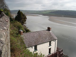
The River Towy is one of the longest rivers flowing entirely within Wales. Its total length is 120 km (75 mi). It is noted for its sea trout and salmon fishing.
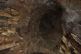
The Dolaucothi Gold Mines, also known as the Ogofau Gold Mine, are ancient Roman surface and underground mines located in the valley of the River Cothi, near Pumsaint, Carmarthenshire, Wales. The gold mines are located within the Dolaucothi Estate which is now owned by the National Trust.

Pumsaint is a village in Carmarthenshire, Wales, halfway between Llanwrda and Lampeter on the A482 in the valley of the Afon Cothi. It forms part of the extensive estate of Dolaucothi, which is owned by the National Trust.
The River Taf is a river in West Wales. It rises in the Preseli Hills, Pembrokeshire, and continues through Carmarthenshire to Laugharne. It is one of the three rivers to enter the sea on the east side of Carmarthen Bay. The other two are the River Gwendraeth and River Tywi.

The River Heddon is a river in Devon, in the south of England. Running along the western edges of Exmoor, the river reaches the North Devon coast at Heddon's Mouth. The nearest road access to the beach is at Hunter's Inn, approximately 1.6-kilometre (1 mi) south of sea-fall. The named river flows for 8.8 kilometres (5.5 mi) and drains an area of 17.07 square kilometres (6.59 sq mi).

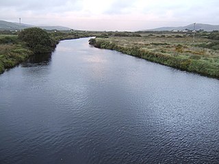
The River Gwendraeth is a river in Carmarthenshire in West Wales.
Ystrad Tywi is a region of southwest Wales situated on both banks of the River Towy. Although Ystrad Tywi was never a kingdom itself, it was historically a valuable territory and was fought over by the various kings of Dyfed, Deheubarth, Seisyllwg, Gwynedd, Morgannwg and the Normans.
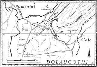
Luentinum or Loventium refers to the Roman fort at Pumsaint, Carmarthenshire. The 1.9 hectares site lies either side of the A482 in Pumsaint and was in use from the mid 70s AD to around 120 AD. It may have had particular functions associated with the adjacent Dolaucothi Gold Mines. It formed part of a network of at least 30 forts across Wales, such as Llandovery, Bremia/Llanio near Llanddewi Brefi, and the fort at Llandeilo. The Roman road Sarn Helen, which runs past the Llanio and Llandovery forts was nearby.
Brechfa, situated between Llandeilo and Carmarthen in the county of Carmarthenshire, Wales, is a village that has existed since the 6th century at the top of the Cothi Valley. Brechfa village is set in countryside, as well as being located by the Brechfa Forest

The River Swilgate is a small river that flows through Gloucestershire, England.

Cynwyl Gaeo is a parish and community located in rural Carmarthenshire, Wales, near the boundary with Ceredigion, in the upper Cothi valley about halfway between Lampeter and Llandovery. The population of the village at the United Kingdom Census 2011 was 940. It includes the villages of Caio (Caeo), Crug-y-bar, Cwrtycadno, Ffarmers and Pumsaint.

Pont-ar-gothi is a village in Carmarthenshire, West Wales. The village takes its name from the bridge where the A40 Road trunk road crosses the River Cothi. It lies some 10 miles (16 km) east of Carmarthen.

The River Menalhyl is a river in Cornwall, England, that flows through the civil parishes of St Columb Major and Mawgan-in-Pydar. Its length is about 12 miles and it flows in a generally north-west direction. The name comes from the Cornish words melyn meaning mill and heyl meaning estuary - estuary mills. The name was recorded as Mellynheyl in the 19th century, but it had been known as Glyvion.
The Little Androscoggin River is a 51.4-mile-long (82.7 km) river in Maine. It flows from Bryant Pond in Woodstock to its confluence with the Androscoggin River in Auburn. The Androscoggin flows into Merrymeeting Bay in the Kennebec River estuary.

Afon Annell is a small river in Carmarthenshire, Wales.

The Afon Twrch is a short river in Carmarthenshire, West Wales. It joins the River Cothi at the village of Pumsaint, near to which are the Roman gold mines of Dolaucothi.

The Afon Marlais is a right-bank tributary of the Afon Cothi in Carmarthenshire, West Wales. It rises on the slopes of Mynydd Llanfihangel-rhos-y-corn and Mynydd Tre-beddau and flows south-eastwards through Brechfa Forest before reaching the village of Brechfa. After a further kilometre it joins the Cothi immediately downstream of Pont Ynys-Brechfa.
The River Inny is a river in County Kerry, Ireland.
Edwinsford is a small hamlet situated about the historic Edwinsford Estate and fishery on the river Cothi, a tributary of the River Tywi, in Carmarthenshire, Wales. It lies to the north of Talley, at the confluence of roads toward Llansawel and Crugybar.
