
Gold Canyon is a census-designated place (CDP) in Pinal County, Arizona, United States. The population was 10,159 at the 2010 census. The community is sometimes incorrectly called Gold Camp.

Skeleton Canyon, called Canon Bonita by the Mexicans, is located 30 miles (50 km) northeast of the town of Douglas, Arizona, in the Peloncillo Mountains, which straddle the modern Arizona and New Mexico state line, in the New Mexico Bootheel region.

Northeast Arizona is a region of the U.S. state of Arizona commonly including Apache County and Navajo County. Some notable towns there are St. Johns, Eagar, Holbrook, Show Low, Winslow, Window Rock, Fort Defiance, Ganado, Chinle, and Kayenta.
The Deer Creek Trail is a hiking trail on the North Rim of the Grand Canyon National Park, located in the U.S. state of Arizona.
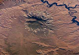
The Navajo Section is a physiographic section of the larger Colorado Plateaus Province, which in turn is part of the larger Intermontane Plateaus physiographic Division.
Eagle Creek is a 58.5-mile-long (94.1 km) river located 50 miles (80 km) northwest of Clifton, Arizona, United States, at the base of the White Mountain Range. It is a tributary of the Gila River.
The San Simon Valley is a broad valley east of the Chiricahua Mountains, in the northeast corner of Cochise County, Arizona and southeastern Graham County, with a small portion near Antelope Pass in Hidalgo County of southwestern New Mexico. The valley trends generally north-south but in its northern portion trends northwest-southeast. The San Simon Valley separates the Chiricahua Mountains, Dos Cabezas Mountains and Pinaleno Mountains on the west from the Peloncillo Mountains and the smaller Whitlock Mountains to the east.

Rucker Canyon is a major canyon draining the western central-south of the Chiricahua Mountains, the central landform of the eastern third of Cochise County, Arizona's extreme southeast, bordering southwest New Mexico. It is famous for historic Camp Rucker.
Black Creek of Arizona is a 55-mi (89 km) long north tributary of the Puerco River, in northeast Arizona and northwest New Mexico.
Agua Sal Creek is a stream located in the Chinle Valley of Apache County, Arizona.
Kinlichee Creek is a stream located in Apache County, Arizona, northeast of the census-designated place of Ganado.

Del Muerto is a census-designated place (CDP) in Apache County, Arizona, United States. The population was 329 at the 2010 census.
San Simon River is an ephemeral river, or stream running through the San Simon Valley in Graham and Cochise County, Arizona and Hidalgo County, New Mexico. Its mouth is at its confluence with the Gila River at Safford in Graham County. Its source is located at 31°51′21″N109°01′27″W.
Stein's Pass, is a gap or mountain pass through the Peloncillo Mountains of Hidalgo County, New Mexico. The pass was named after United States Army Major Enoch Steen, who camped nearby in 1856, as he explored the recently acquired Gadsden Purchase. The pass is in the form of a canyon cut though the mountains through which Steins Creek flows to the west just west of the apex of the pass to the canyon mouth at 32°13′19″N109°01′48″W.
Steins Creek, a Stream or Arroyo tributary to the San Simon River, that arises within an east-west running canyon, in Hidalgo County, New Mexico with its mouth in Cochise County, Arizona. This canyon provides the gap, called Stein's Pass, through which the railroad and Interstate 10 pass through the Peloncillo Mountains. Steins Creek has its source at 32°14′10″N108°59′43″W, and its mouth in the San Simon Valley, where its waters usually sink into the soil, short of any confluence with the San Simon River.

Laguña Creek also formerly also known as Tyende Creek, is a stream in the Navajo and Apache Counties of Arizona. Laguña Creek has its source at 36°41′15″N110°30′36″W, at the conflence of Long Canyon and Dowozhiebito Canyon at an elevation of 6325 feet / 1928 meters at the head of Tsegi Canyon. Its mouth is in the Chinle Valley at its confluence with Chinle Wash which together forms Chinle Creek, at an elevation of 4774 feet / 1455 meters. Chinle Creek is a tributary of San Juan River which is in turn a tributary of the Colorado River.
Chinle Wash is an arroyo, tributary to Chinle Creek in Apache County, Arizona. Its name is derived from the Navajo word ch'inili meaning 'where the waters came out'. Its sources is in Canyon de Chelly National Monument where Canyon de Chelly and Canyon del Muerto have their confluence at an elevation of 5,616 feet at 36°08′35″N109°29′17″W. It then trends northwest to its confluence with Laguña Creek where it forms Chinle Creek, 7 miles northeast of Dennehotso, Arizona at an elevation of 4,774 feet / 1,455 meters.

Chinle Creek is a tributary stream of the San Juan River in Apache County, Arizona and San Juan County, Utah. Its source is at 36°53′40″N109°44′37″W, the confluence of Laguña Creek with Chinle Wash where it forms Chinle Creek, 7 miles northeast of Dennehotso, Arizona at an elevation of 4,774 feet (1,455 m). Its mouth is at its confluence with the San Juan River at 37°11′53″N109°42′57″W at an elevation of 4,229 feet (1,289 m), 9 miles northeast of Mexican Hat, Utah.
Walker Creek is a stream in Apache County, Arizona. Its mouth is at an elevation of 4,688 feet / 1,429 meters at its confluence with Chinle Creek. Its source is located at 36°41′28″N109°15′04″W, the confluence of Alcove Canyon and Tah Chin Lini Canyon in the Carrizo Mountains, from which it flows west and northwest to Chinle Creek at 36°57′42″N109°41′35″W. Hogansaani Spring, a tributary, is located on the south side of Walker Creek, at an elevation of 5,102 feet (1,555 m), midway downstream Walker Creek to its confluence with Chinle Creek.
Coyote Wash is a tributary stream of Whiskey Creek in the watershed of the San Juan River and Colorado River. The confluence with Whiskey Creek lies within the Canyon de Chelly National Monument. It is entirely in Apache County, Arizona. Its mouth is located at an elevation of 7,080 feet (2,160 m) at its confluence with Whiskey Creek. Its source is at an elevation of 7,096 feet (2,163 m) at the confluence of Crystal Creek and Cattail Wash 36°04′52″N109°08′56″W.


