Aldercrest-Banyon landslide

Last updated

The Aldercrest-Banyon landslide was a major slow-moving landslide in the east Kelso, Washington neighborhood of Aldercrest beginning in early 1998 through 1999. The disaster ended up being one of the worst urban landslides in United States history in terms of cost. The landslide is one of the most notable in Washington state, which has many landslides due to its mountainous terrain. The Aldercrest-Banyon landslide was the first landslide disaster in the United States that the Federal Emergency Management Agency (FEMA) declared an official disaster area. [1]

Landslide type of natural disaster, geological phenomenon

The term landslide or, less frequently, landslip, refers to several forms of mass wasting that include a wide range of ground movements, such as rockfalls, deep-seated slope failures, mudflows and debris flows. Landslides occur in a variety of environments, characterized by either steep or gentle slope gradients: from mountain ranges to coastal cliffs or even underwater, in which case they are called submarine landslides. Gravity is the primary driving force for a landslide to occur, but there are other factors affecting slope stability which produce specific conditions that make a slope prone to failure. In many cases, the landslide is triggered by a specific event, although this is not always identifiable.

Kelso, Washington City in Washington, United States

Kelso is a city in the southwestern part of the U.S. state of Washington and is the county seat of Cowlitz County. At the 2010 census, the population was 11,925. Kelso is part of the Longview, Washington Metropolitan Statistical Area, which has a population of 102,410. Kelso shares its long western border with Longview. It is near Mount St. Helens.

United States federal republic in North America

The United States of America (USA), commonly known as the United States or America, is a country composed of 50 states, a federal district, five major self-governing territories, and various possessions. At 3.8 million square miles, the United States is the world's third or fourth largest country by total area and is slightly smaller than the entire continent of Europe's 3.9 million square miles. With a population of over 327 million people, the U.S. is the third most populous country. The capital is Washington, D.C., and the largest city by population is New York City. Forty-eight states and the capital's federal district are contiguous in North America between Canada and Mexico. The State of Alaska is in the northwest corner of North America, bordered by Canada to the east and across the Bering Strait from Russia to the west. The State of Hawaii is an archipelago in the mid-Pacific Ocean. The U.S. territories are scattered about the Pacific Ocean and the Caribbean Sea, stretching across nine official time zones. The extremely diverse geography, climate, and wildlife of the United States make it one of the world's 17 megadiverse countries.

Contents

History

The 80 acres (32 ha) Aldercrest residential neighborhood was completed in three phases between 1973 and 1979. [2] It is built on an ancient landslide that may have occurred during the Missoula floods (15,300–12,700 years ago). [3] Approximately 2 to 14 million years ago, the Columbia River deposited gravels, sands, silts, and clays and are known as the Troutdale Formation. In the area of the landslide, along a northwest-southeast trending ridge about one-half mile east of Interstate 5, the Troutdale Formation ranges from approximately 40 to 500 feet (12 to 152 m) thick in the Kelso area and was deposited upon a much older, near-shore marine sedimentary deposit known as the Cowlitz Formation. These areas are known for landslide activity. [4] [5] At the base of the slope is the Coweeman River.

Columbia River river in North America; flows from British Columbia, through Washington, and along the Washington–Oregon border to the Pacific Ocean

The Columbia River is the largest river in the Pacific Northwest region of North America. The river rises in the Rocky Mountains of British Columbia, Canada. It flows northwest and then south into the US state of Washington, then turns west to form most of the border between Washington and the state of Oregon before emptying into the Pacific Ocean. The river is 1,243 miles (2,000 km) long, and its largest tributary is the Snake River. Its drainage basin is roughly the size of France and extends into seven US states and a Canadian province. The fourth-largest river in the United States by volume, the Columbia has the greatest flow of any North American river entering the Pacific.

The Cowlitz Formation is a geologic formation in Washington (state). It preserves fossils dating back to the Paleogene period.

Coweeman River river in the United States of America

The Coweeman River is a tributary of the Cowlitz River, in the South West corner of the U.S. state of Washington. Its name comes from the Cowlitz word ko-wee-na, meaning "short one", referring to a short Indian who once lived along the river.

The landslide

Following 3.5 years of above average rainfall the water loosened layers of clay but did not percolate through, and the load on the earth was increased. The Troutdale and Cowlitz formations began to slip. [2] Also a road excavation in February 1998 across the lower part of the slide may have been a trigger to cause the initial reactivated movement, which then caused storm drains to break and storm water to be fed back into the slide. Logging operations at the toe of the landslide may also have contributed to the reactivation. [3] Aldercrest-Banyon residents began to see signs of ground movement. In February 1998 underground utilities began to break from the pressure and once broken storm drains fed abundant water into the system, it further increased the earth movement rates. [1] By March homes began to show signs of movement and stress. These included jammed doors and windows, and concrete foundations cracking. Other signs were separation of chimneys from foundations, drywall bulging over nailheads, twisted ceiling beams, water flowing through foundation cracks, bulging walls, kitchen cabinets separating from the walls and creaking, popping and snapping noises could be heard in the homes. [4]

In mid-April 1998, a 2.5 to 6 feet (0.76 to 1.83 m) high crack developed on the natural slope causing the evacuation of two homes. The city of Kelso did its best to repair roads and moved utilities above ground so residents could stay in their homes for as long as possible.

Movement of the upper slope gradually increased into a continuous headscarp approximately 1,500 feet (460 m) long with a vertical separation of 30 feet (9.1 m) by June 1998. The landslide is about 3,000 feet (915 m) wide by 1,500 feet (457 m) in length had reached a height of 125 feet (38 m). In June 1998, 54 homes were located within the active limits of the landslide and during the winter of 1998–99, 3 more homes were swallowed up. The maximum slide movement in 1998 was about 6 to 12 inches (15 to 30 cm) per day [3] [6]

On October 16, 1998, President Bill Clinton and the Federal Emergency Management Agency issued a Presidential Disaster Declaration. Some assistance was then given to the affected residents. The city of Kelso condemned 137 homes and disbursed roughly $4.7 million in FEMA funds to those evacuated. [6]

Bill Clinton 42nd president of the United States

William Jefferson Clinton is an American politician who served as the 42nd president of the United States from 1993 to 2001. Prior to the presidency, he was the governor of Arkansas from 1979 to 1981, and again from 1983 to 1992, and the attorney general of Arkansas from 1977 to 1979. A member of the Democratic Party, Clinton was ideologically a New Democrat and many of his policies reflected a centrist "Third Way" political philosophy.

Aftermath and damage

The homes and infrastructure suffered more than $70 million of damage. FEMA and the state of Washington offered to buy out 127 homeowners at 30 cents on the dollar. This was the second largest landslide disaster in US history involving homes on a landslide. The largest was the 1956 Portuguese Bend landslide in Palos Verdes Hills of Southern California, when 130 homes were destroyed. [1] All but eleven homeowners took the offer accepting the risk that the upper ridge of possibly reactivating. The federal government has removed all of the purchased homes. [3]

Palos Verdes Hills

The Palos Verdes Hills are a low mountain range on the southwestern coast of Los Angeles County, California. They sit atop the Palos Verdes Peninsula, a sub-region of the Los Angeles metropolitan area.

Southern California Place in California, United States

Southern California is a geographic and cultural region that generally comprises California's southernmost counties, and is the second most populous urban agglomeration in the United States. The region is traditionally described as eight counties, based on demographics and economic ties: Imperial, Los Angeles, Orange, Riverside, San Bernardino, San Diego, Santa Barbara, and Ventura. The more extensive 10-county definition, which includes Kern and San Luis Obispo counties, is also used and is based on historical political divisions.

In 2000, in response to the Aldercrest–Banyon and other recent damaging landslides in Cowlitz County, the Washington Division of Geology and Earth Resources began a geographic information systems-based landslide inventory and slope stability mapping project. In total, 260 square miles (680 sq km) of urbanizing lands in Cowlitz County between the Toutle River and the Lewis and Wahkiakum County lines have been mapped for all landslides, regardless of age. [3]

See also

Related Research Articles

Cowlitz County, Washington County in the United States

Cowlitz County is a county located in the U.S. state of Washington. As of the 2010 census, its population was 102,410. The county seat is Kelso, and its largest city is Longview. The county was formed in April 1854. Its name derives from the anglicized version of the Cowlitz Indian term, Cow-e-liske, meaning either "river of shifting sands" or "capturing the medicine spirit."

Longview, Washington City in Washington, United States

Longview is a city in Cowlitz County, Washington, United States. It is the principal city of the Longview, Washington Metropolitan Statistical Area, which encompasses all of Cowlitz County. Longview's population was 36,648 at the time of the 2010 census, making it the largest city in Cowlitz County. The city is located in southwestern Washington, at the junction of the Cowlitz and Columbia rivers. Longview shares a border with Kelso to the east, which is the county seat.

Megatsunami A very large wave created by a large, sudden displacement of material into a body of water

A megatsunami is a very large wave created by a large, sudden displacement of material into a body of water.

Slump (geology)

A slump is a form of mass wasting that occurs when a coherent mass of loosely consolidated materials or rock layers moves a short distance down a slope. Movement is characterized by sliding along a concave-upward or planar surface. Causes of slumping include earthquake shocks, thorough wetting, freezing and thawing, undercutting, and loading of a slope.

Cowlitz River river in the United States of America

The Cowlitz River is a river in the state of Washington in the United States, a tributary of the Columbia River. Its tributaries drain a large region including the slopes of Mount Rainier, Mount Adams, and Mount St. Helens.

1980 eruption of Mount St. Helens Major volcanic eruption in Washington state, US

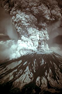
On May 18, 1980, a major volcanic eruption occurred at Mount St. Helens, a volcano located in Skamania County, in the U.S. state of Washington. The eruption was the most significant volcanic eruption to occur in the contiguous 48 U.S. states since the much smaller 1915 eruption of Lassen Peak in California. It has often been declared as the most disastrous volcanic eruption in U.S. history. The eruption was preceded by a two-month series of earthquakes and steam-venting episodes, caused by an injection of magma at shallow depth below the volcano that created a large bulge and a fracture system on the mountain's north slope.

Mass wasting geomorphic process by which soil, sand, regolith, and rock move downslope

Mass wasting, also known as slope movement or mass movement, is the geomorphic process by which soil, sand, regolith, and rock move downslope typically as a solid, continuous or discontinuous mass, largely under the force of gravity, but frequently with characteristics of a flow as in debris flows and mudflows. Types of mass wasting include creep, slides, flows, topples, and falls, each with its own characteristic features, and taking place over timescales from seconds to hundreds of years. Mass wasting occurs on both terrestrial and submarine slopes, and has been observed on Earth, Mars, Venus, and Jupiter's moon Io.

Portuguese Bend bay on the Palos Verdes Peninsula in Ranchjo Palos Verdes, California

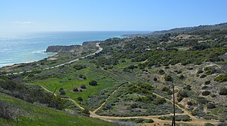
The Portuguese Bend region is the largest area of natural vegetation remaining on the Palos Verdes Peninsula, in Los Angeles County, California. Though once slated for development, the area is geologically unstable and is unsuitable for building.

Mudflow

A mudflow or mud flow is a form of mass wasting involving "very rapid to extremely rapid surging flow" of debris that has become partially or fully liquified by the addition of significant amounts of water to the source material.

Silver Star Mountain (Skamania County, Washington)

Silver Star Mountain is an extinct volcano of the Cascade Range in the U.S. state of Washington. Consisting of late Eocene to Oligocene epoch rock, it lies within the Gifford Pinchot National Forest. Long inactive, the volcano sits over three lithologic units, including the large Silver Star Granodiorite unit.

Causes of landslides

The causes of landslides are usually related to instabilities in slopes. It is usually possible to identify one or more landslide causes and one landslide trigger. The difference between these two concepts is subtle but important. The landslide causes are the reasons that a landslide occurred in that location and at that time. Landslide causes are listed in the following table, and include geological factors, morphological factors, physical factors and factors associated with human activity.

The Swift Creek Landslide is an active, slow moving landslide located in western Washington, USA, due east of Everson on Sumas Mountain. Asbestos laden sediment originating from the landslide has recently generated much interest in this area. Asbestos is a known carcinogen. EPA sampling has documented asbestos in sediments in Swift Creek and in downstream Sumas River. Average asbestos levels in Swift Creek dredged material exceed the level that, in construction materials, triggers worker safety requirements and material handling and disposal regulations.

The Malpa landslide was one of the worst landslides in India. On 18 August 1998 at 3.00 a.m., massive landslides wiped away the entire village of Malpa in the Pithoragarh district of Uttarakhand, then in Uttar Pradesh in Kali Valley of Higher Kumaon division of the Himalayas. The rockfall started on 16 August bringing down huge rocks which initially killed three mules. A total of 221 people died, including 60 Hindu pilgrims traveling to Tibet as part of "Kailash Manas Sarovar Yatra". One noted death was that of the Indian dancer Protima Bedi. The rockfall continued till 21 August. As the area lies in a seismic zone, the earthquakes of 1979 and 1980 may have been the underlying cause, as was attributed by a report of the Wadia Institute of Himalayan Geology.

Greenleaf Peak mountain in United States of America

Greenleaf Peak is a mountain in the Cascade Range in the U.S. state of Washington, located on the north side of the Columbia River near Table Mountain, in the Columbia River Gorge. The peak lies within the Columbia River Gorge National Scenic Area near Bonneville Dam. It is 3,424 feet (1,044 m) in elevation. Botanist David Douglas climbed to the summit in September 1825, making this the first recorded mountain ascent in what is now Washington state.

2005 La Conchita landslide

On January 10, 2005, a major landslide occurred in the town of La Conchita, California. The landslide killed 10 people, and destroyed or damaged dozens of houses. The landslide occurred on part of a previous landslide that occurred in 1995. The historic slides are part of the larger Rincon Mountain slide, which "started many thousands of years ago and will continue generating slides in the future."

2014 Oso mudslide landslide east of Oso, Washington, United States

A major landslide occurred 4 miles (6.4 km) east of Oso, Washington, United States, on March 22, 2014, at 10:37 a.m. local time. A portion of an unstable hill collapsed, sending mud and debris to the south across the North Fork of the Stillaguamish River, engulfing a rural neighborhood, and covering an area of approximately 1 square mile (2.6 km2). Forty-three people were killed and 49 homes and other structures destroyed.

Allen Street Bridge disaster bridge in United States of America

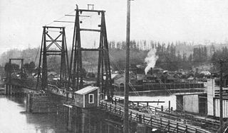
Allen Street Bridge was a bridge over the Cowlitz River between Kelso, Washington and Longview, Washington that collapsed on January 3, 1923.

2010 Mount Meager landslide

The 2010 Mount Meager landslide was a large catastrophic debris avalanche that occurred in southwestern British Columbia, Canada, on August 6 at 3:27 a.m. PDT (UTC-7). Over 45,000,000 m3 (1.6×10⁹ cu ft) of debris slid down Mount Meager, temporarily blocking Meager Creek and destroying local bridges, roads and equipment. It was one of the largest landslides in Canadian history and one of over 20 landslides to have occurred from the Mount Meager massif in the last 10,000 years.

References

  1. 1 2 3 Scott Burns. "Prevention Is the Best Medicine: Doing Site Evaluations to Prevent Geological Hazard Catastrophes". GeoTimes. Retrieved 29 June 2011.
  2. 1 2 Florangela Davila (1 August 1999). "A Monster Mudslide Slowly Swallows A Kelso Neighborhood". The Seattle Times. Retrieved 1 July 2011.
  3. 1 2 3 4 5 "Field Trip, Stevenson to Castle Rock" (PDF). Washington Department of Resources. Retrieved 1 July 2011.
  4. 1 2 Michelle Howell, Darren Beckstrand and A.G. Flynn (Winter 1999). "Ground Movement Study Haussler Road Area Kelso, Washington" (PDF). Portland State University. Retrieved 1 July 2011.
  5. Kenneth G. Buss (21 July 1999). "Report Geotechnical Engineering Services, Slope Stability Evaluation, Vista Neighborhood, Kelso, Washington for City of Kelso". GeoEngineers, Inc. Retrieved 1 July 2011.
  6. 1 2 J. David Rogers. "Aldercrest-Banyon Landslide Kelso, Washington (1998-99)". University of Missouri-Rolla. Retrieved 29 June 2011.

Coordinates: 46°7′56″N122°52′48″W / 46.13222°N 122.88000°W / 46.13222; -122.88000