
Surfing is a surface water sport in which an individual, a surfer, uses a board to ride on the forward section, or face, of a moving wave of water, which usually carries the surfer towards the shore. Waves suitable for surfing are primarily found on ocean shores, but can also be found in standing waves in the open ocean, in lakes, in rivers in the form of a tidal bore, or in wave pools.

Waimea Bay is located in Haleiwa on the North Shore of O'ahu in the Hawaiian Islands at the mouth of the Waimea River. Waimea Valley extends to the east of Waimea Bay. Waimea means "reddish water" in Hawaiian.

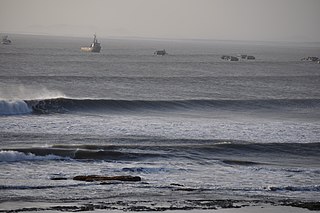
Croyde is a village on the west-facing coastline of North Devon, England. The village lies on the South West Coast Path near to Baggy Point, which is owned by the National Trust. It lies within the North Devon Coast Area of Outstanding Natural Beauty.
The Shark Island Challenge (SIC), held near Cronulla, in Sydney, New South Wales, Australia, is the most celebrated World Tour event in bodyboarding since the elimination of the Teahupoo Challenge (Teahupoo) from the world bodyboarding tour.

Yamba is a town in the Northern Rivers region of New South Wales, Australia located at the mouth of the Clarence River.

Hoʻokipa is a beach on the north shore of Maui, Hawaii, United States, perhaps the most renowned windsurfing site in the world. A combination of large, well-shaped waves breaking across a system of reefs that extend across the bay and consistently strong winds make it ideal for the sport.

A swell, also sometimes referred to as ground swell, in the context of an ocean, sea or lake, is a series of mechanical waves that propagate along the interface between water and air under the predominating influence of gravity, and thus are often referred to as surface gravity waves. These surface gravity waves have their origin as wind waves, but are the consequence of dispersion of wind waves from distant weather systems, where wind blows for a duration of time over a fetch of water, and these waves move out from the source area at speeds that are a function of wave period and length. More generally, a swell consists of wind-generated waves that are not greatly affected by the local wind at that time. Swell waves often have a relatively long wavelength, as short wavelength waves carry less energy and dissipate faster, but this varies due to the size, strength, and duration of the weather system responsible for the swell and the size of the water body, and varies from event to event, and from the same event, over time. Occasionally, swells that are longer than 700m occur as a result of the most severe storms.

Hurricane Fico was the longest-lived hurricane of the 1978 Pacific hurricane season and became the longest-lasting Pacific hurricane on record, a record broken by Hurricane Tina fourteen years later. The sixth tropical storm, fourth hurricane, and third major hurricane, Fico developed from a tropical disturbance off the Pacific coast of Mexico on July 9. It moved northwestward and then westward, quickly reaching peak winds of 140 mph (230 km/h) on July 12. Moving nearly due westward, the intensity of Fico fluctuated from Category 1 to Category 4 status on the Saffir–Simpson hurricane scale for the following days, and it passed about 170 miles (270 km) south of Hawaii on July 20 with winds of 115 mph (185 km/h). Fico slowly weakened as it turned to the northwest over cooler waters, and became an extratropical cyclone on July 28 to the northeast of Midway Island.

Angourie is a coastal village in the Clarence Valley Council of New South Wales, Australia. Angourie is located 5 km south of Yamba, New South Wales, and is at the northern tip of Yuraygir National Park. Towns that surround Angourie are Yamba and Wooloweyah.

Hurricane Felix caused severe beach erosion along the East Coast of the United States in August 1995. The seventh tropical cyclone, sixth named storm, and third hurricane of the 1995 Atlantic hurricane season, Felix was also the strongest hurricane in the Atlantic Ocean since Category 5 Hurricane Andrew in 1992. It developed from a tropical wave in the eastern Atlantic Ocean on August 8, and slowly intensified, reaching hurricane status on August 11. Under favorable conditions, Felix began to rapidly deepen while curving northwestward. Late on August 12, Felix peaked as a low-end Category 4 hurricane. However, it soon weakened rapidly to a Category 1 hurricane. Less than three days later, Felix passed only 75 mi (120 km) southeast of Bermuda. Although it also posed a threat to the East Coast of the United States, Felix curved northward and then east-northeastward while remaining offshore, thereby avoiding landfall. Felix briefly threatened Bermuda again, but weakened to a tropical storm and turned back to the northeast on August 20. It accelerated east-northeastward, and passed a short distance offshore of Newfoundland, where Felix transitioned into an extratropical storm on August 22.
G-Land, also known as Plengkung Beach, is an internationally renowned surf break on Grajagan Bay, Banyuwangi, Alas Purwo National Park, East Java, Indonesia, about half a day by road from the popular tourist destinations of Bali. It is most commonly reached via boat charter from Bali.
Malabrigo also called unofficially Puerto Chicama, is a port and small coastal city in northwestern Peru, located in La Libertad Region, some 70 km north of Trujillo city. The town is home to the Chicama wave, the first legally protected wave in the world, as well as the world's longest left-breaking wave—see External Links.
Surf forecasting is the process of using offshore swell data to predict onshore wave conditions. It is used by millions of people across the world, including professionals who put their forecasts online, meteorologists who work for news crews, and surfers all over the world. It is impossible to make an exact prediction of the surf, but by knowing a few factors a good prediction can be made. One needs to have an understanding of how waves are formed, a basic knowledge of bathymetry, and information about the surf spot being forecasted to accurately forecast the surf.

Hurricane Gabrielle was a powerful tropical cyclone that caused nine fatalities in the United States and Canada, despite remaining hundreds of miles offshore. The tenth tropical cyclone, seventh named storm, fifth hurricane, and first major hurricane of the 1989 Atlantic hurricane season, Gabrielle developed on August 30 from a tropical wave near the west coast of Africa. Under favorable conditions, the depression intensified and became Tropical Storm Gabrielle early on the following day. Rapid strengthening occurred thereafter, with Gabrielle reaching hurricane intensity early on September 1. After becoming a hurricane, further intensification was steady, though by September 5, Gabrielle peaked as a moderate Category 4 hurricane. On the following day, Gabrielle began to slowly level-off in intensity, while gradually curving northward. After weakening to a Category 2 hurricane, the storm passed east of Bermuda on September 8.

A surf break is a permanent obstruction such as a coral reef, rock, shoal, or headland that causes a wave to break, forming a barreling wave or other wave that can be surfed, before it eventually collapses. The topography of the seabed determines the shape of the wave and type of break. Since shoals can change size and location, affecting the break, it takes commitment and skill to find good breaks. Some surf breaks are quite dangerous, since the surfer can collide with a reef or rocks below the water.

This glossary of surfing includes some of the extensive vocabulary used to describe various aspects of the sport of surfing as described in literature on the subject.[a][b] In some cases terms have spread to a wider cultural use. These terms were originally coined by people who were directly involved in the sport of surfing.
Nembrala is a beach on Rote Island, East Nusa Tenggara, Indonesia. The beach is well known for surfing.

Cowaramup Bombora is a big wave open-ocean surf break found on the south-west coast of Western Australia. It is located 2 km (1.2 mi) offshore west of Gracetown which is near the town of Margaret River, world-renowned for its surf, and is 265 km (165 mi) south of the capital city Perth.

Sidi Kaouki is a small town located 25 km south of Essaouira. It is a rural commune in Essaouira Province of the Marrakech-Tensift-Al Haouz region of Morocco. At the time of the 2004 census, the commune had a total population of 4335 people living in 902 households.

Uluwatu is a region on the south-western tip of the Bukit Peninsula of Bali, Indonesia. It is home to the Pura Luhur Uluwatu Temple.