Lancaster is a charter city in northern Los Angeles County, in the Antelope Valley of the western Mojave Desert in Southern California. As of the 2020 census, the population was 173,516, making Lancaster the 153rd largest city in the United States and the 30th largest in California. Lancaster is part of a twin city complex with its southern neighbor Palmdale, and together they are the principal cities within the Antelope Valley region.

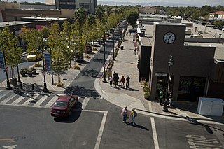
Palmdale is a city in northern Los Angeles County in the U.S. state of California. The city lies in the Antelope Valley region of Southern California. The San Gabriel Mountains separate Palmdale from the Los Angeles Basin to the south.

Antelope Valley California Poppy Reserve is a state-protected reserve of California, United States, harboring the most consistent blooms of California poppies, the state flower. The reserve is located in the rural west side of Antelope Valley in northern Los Angeles County, 15 miles (24 km) west of Lancaster. To the north is Kern County. The reserve is at an elevation ranging from 2,600 to 3,000 feet above sea level, in the Mojave Desert climate zone. The reserve is administered by the California Department of Parks and Recreation. Other wildflowers within the reserve include the owl's clover, lupine, goldfields, cream cups and coreopsis.

Arthur B. Ripley Desert Woodland State Park is a state park in the western Antelope Valley in Southern California. The park protects mature stands of Joshua trees and California juniper trees in their western Mojave Desert habitat.

The Antelope Valley is located in northern Los Angeles County, California, and the southeast portion of Kern County, California, and constitutes the western tip of the Mojave Desert. It is situated between the Tehachapi, Sierra Pelona, and the San Gabriel Mountains. The valley was named for the pronghorns that roamed there until they were all eliminated in the 1880s, mostly by hunting, or resettled in other areas. The principal cities in the Antelope Valley are Palmdale and Lancaster.

State Route 14 is a north–south state highway in the U.S. state of California that connects Los Angeles to the northern Mojave Desert. The southern portion of the highway is signed as the Antelope Valley Freeway. The route connects Interstate 5 on the border of the city of Santa Clarita to the north and the Los Angeles neighborhoods of Granada Hills and Sylmar to the south, with U.S. Route 395 (US 395) near Inyokern. Legislatively, the route extends south of I-5 to SR 1 in the Pacific Palisades area of Los Angeles; however, the portion south of the junction with I-5 has not been constructed. The southern part of the constructed route is a busy commuter freeway serving and connecting the cities of Santa Clarita, Palmdale, and Lancaster to the rest of the Greater Los Angeles area. The northern portion, from Vincent to US 395, is legislatively named the Aerospace Highway, as the highway serves Edwards Air Force Base, once one of the primary landing strips for NASA's Space Shuttle, as well as the Naval Air Weapons Station China Lake that supports military aerospace research, development and testing. This section is rural, following the line between the hot Mojave desert and the forming Sierra Nevada mountain range. Most of SR 14 is loosely paralleled by a rail line originally built by the Southern Pacific Railroad, and was once the primary rail link between Los Angeles and Northern California. While no longer a primary rail line, the southern half of this line is now used for the Antelope Valley Line of the Metrolink commuter rail system.
State Route 138 is an east–west state highway in the U.S. state of California that generally follows the northern foothills of the San Gabriel Mountains and the western Mojave Desert. The scenic highway begins in the west at its junction with Interstate 5 located south of Gorman in the Sierra Pelona Mountains, continues eastward through the Antelope Valley and Cajon Pass, to its junction with State Route 18 in the east, located in the San Bernardino Mountains south of Crestline.

Antelope Acres is an unincorporated community in Los Angeles County, California. It lies at an elevation of 2425 feet.

Neenach is an agricultural settlement in northwestern Los Angeles County, California, with a population of about 800. It is facing a massive change with the proposed construction of a 23,000-home planned community to its north called Centennial.
Antelope Valley College (AVC) is a public community college in Lancaster, California. It is part of the California Community College system. It is operated by the Antelope Valley Community College District, with a primary service area of 1,945 square miles (5,040 km2) covering portions of Los Angeles and Kern counties. Instruction is offered at several sites, including Palmdale and Lancaster, and through online and instructional television courses.
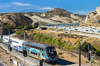
The Antelope Valley Line is a commuter rail line that serves the Northern Los Angeles County area as part of the Metrolink system. The northern segment of the line is rural in character because it travels through the sparsely populated Soledad Canyon between Santa Clarita and Palmdale, serving the small community of Acton along the way. Other portions of its route parallel the former US Route 6, now San Fernando Road and Sierra Highway and this line is the only Metrolink line to be entirely in Los Angeles County.

Antelope Valley High School is located in Lancaster, California, and is part of the Antelope Valley Union High School District, in northernmost Los Angeles County, California. It was founded in 1912, and had its first graduating class in 1912. It is located near the western edge of the Mojave Desert. At the time of its founding, classes were held at the Women's Independence Hall on Cedar Ave. and Lancaster Blvd. until a permanent building could be built. In July 1914, construction was planned to begin on a concrete building, Central Hall, but construction didn’t begin until 1915 and was completed in mid-1915. However, a strike over unpaid wages prevented students from entering the new building at the beginning of the 1915 school year. It was settled, and students began their classes in the new building in October 1915. The school was a residential boarding school serving students from farms and ranches from north Los Angeles and south Kern counties. At present, the school primarily serves the population of Lancaster, California.
The Antelope Valley Union High School District (A.V.U.H.S.D.) is located in the Antelope Valley area of California, in northern Los Angeles County.
Grass Valley may refer to:

Lancaster station is owned by and located in the city of Lancaster, California. It serves as a transfer point for several public transportation bus routes as well as the final Metrolink train station on the Antelope Valley Line that originates 69 miles (111 km) away in downtown Los Angeles, at Union Station.

Antelope Valley Transit Authority is the transit agency serving the cities of Palmdale, Lancaster and Northern Los Angeles County. Antelope Valley Transit Authority is operated under contract by MV Transportation, and is affiliated with and offers connecting services with Metro and Metrolink. In 2021, the system had a ridership of 1,003,100, or about 4,300 per weekday as of the third quarter of 2022.

The Antelope Valley is a high valley in the eastern Sierra Nevada stretching from Mono County, California to Douglas County, Nevada.

Thomas W. Lackey is an American teacher, law enforcement officer and politician currently serving in the California State Assembly. He is a Republican representing the 34th district, encompassing parts of Antelope Valley, Victor Valley, the San Bernardino Mountains, and the Mojave Desert including Barstow and Twentynine Palms to the Nevada state line. Prior to being elected to the state assembly, he served on the Palmdale Elementary School Board and the Palmdale City Council.

Lake Thompson is a former lake in California. The name is derived from an academic who first speculated on the possibility that a lake existed in lower Antelope Valley. It occupied the area of the lower Antelope Valley and of the lakes Rogers Lake and Rosamond Lake during the Pleistocene. It dried up during the Holocene.