The history of the Republic of the Congo has been marked by diverse civilisations: indigenous, French and post-independence.
The history of Zambia experienced many stages from colonization to independence from Britain on October 24, 1964. Northern Rhodesia became a British sphere of influence in the present-day region of Zambia in 1888, and was officially proclaimed a British protectorate in 1924. After many years of suggested mergers, Southern Rhodesia, Northern Rhodesia, and Nyasaland were merged into the British Federation of Rhodesia and Nyasaland.

The Congo River, formerly also known as the Zaire River, is the second longest river in Africa, shorter only than the Nile, as well as the second largest river in the world by discharge volume, following only the Amazon. It is also the world's deepest recorded river, with measured depths around 219.5 m (720 ft). The Congo-Lualaba-Chambeshi River system has an overall length of 4,700 km (2,920 mi), which makes it the world's ninth-longest river. The Chambeshi is a tributary of the Lualaba River, and Lualaba is the name of the Congo River upstream of Boyoma Falls, extending for 1,800 km (1,120 mi).

Brazzaville is the capital and largest city of the Republic of the Congo. Constituting the financial and administrative centre of the country, it is located on the north side of the Congo River, opposite Kinshasa, the capital city of the Democratic Republic of the Congo.

Uíge is one of the eighteen Provinces of Angola, located in the northwestern part of the country. Its capital city is of the same name.

Central Africa is a subregion of the African continent comprising various countries according to different definitions. Middle Africa is an analogous term used by the United Nations in its geoscheme for Africa and consists of the following countries: Angola, Burundi, Cameroon, Central African Republic, Chad, Democratic Republic of the Congo, Republic of the Congo, Equatorial Guinea, Gabon, Rwanda, and São Tomé and Príncipe. These eleven countries are members of the Economic Community of Central African States (ECCAS). Six of those countries are also members of the Economic and Monetary Community of Central Africa (CEMAC) and share a common currency, the Central African CFA franc.

The Kongo people are a Bantu ethnic group primarily defined as the speakers of Kikongo. Subgroups include the Beembe, Bwende, Vili, Sundi, Yombe, Dondo, Lari, and others.

The Teke people or Bateke, also known as the Tyo or Tio, are a Bantu Central African ethnic group that speak the Teke languages and that mainly inhabit the south, north, and center of the Republic of the Congo, the west of the Democratic Republic of the Congo, with a minority in the south-east of Gabon. Omar Bongo, who was President of Gabon in the late 20th century, was a Teke.

Pool is a department of the Republic of the Congo in the southeastern part of the country. It borders the departments of Bouenza, Lékoumou, and Plateaux. Internationally, it borders the Democratic Republic of the Congo. It also surrounds the commune district of the national capital, Brazzaville.
The pre-colonial history of the modern-day Democratic Republic of the Congo encompasses the history of the Congo Basin region up to the establishment of European colonial rule in the era of New Imperialism and particularly the creation of the Congo Free State and its expansion into the interior after 1885. As the modern territorial boundaries of the Democratic Republic of the Congo did not exist in this period, it is inseparable from the wider pre-colonial histories of Central Africa, the Great Lakes and Rift Valley as well as the Atlantic World and Swahili coast.

The Kingdom of Loango was a pre-colonial African state, during approximately the 16th to 19th centuries in what is now the western part of the Republic of the Congo, Southern Gabon and Cabinda. Situated to the north of the more powerful Kingdom of Kongo, at its height in the 17th century Loango influence extended from Cape St Catherine in the north to almost the mouth of the Congo River.

The Kingdom of Kongo was a kingdom located in central Africa in present-day northern Angola, the western portion of the Democratic Republic of the Congo, and the Republic of the Congo. At its greatest extent it reached from the Atlantic Ocean in the west to the Kwango River in the east, and from the Congo River in the north to the Kwanza River in the south. The kingdom consisted of several core provinces ruled by the Manikongo, the Portuguese version of the Kongo title Mwene Kongo, meaning "lord or ruler of the Kongo kingdom", but its sphere of influence extended to neighbouring kingdoms, such as Ngoyo, Kakongo, Loango, Ndongo and Matamba, the latter two located in what is Angola today.

The Bemba belong to a large group of Bantu peoples mainly in the Northern, Luapula, Muchinga, and the northern Central Province of Zambia. The Bemba entered modern-day Zambia by crossing the Luapula River. One group first came to Zambia by 1740 from Kola. A few other ethnic groups in the Northern and Luapula of Zambia speak languages that are similar to Bemba but do not share a similar origin. The Bemba people are not indigenous to the Copperbelt Province, having reached there only in the 1970s due to employment opportunities in copper mining.

Kakongo was a small kingdom located on the Atlantic coast of Central Africa, in the modern-day Republic of the Congo and Cabinda Province, Angola. Along with its neighboring kingdoms of Ngoyo and Loango, Kakongo became an important political commercial center during the 17th through 19th centuries. The people speak a dialect of the Kikongo language and thus may be considered a part of the Bakongo ethnicity. Kakongo was a vassal of the Kingdom of Kongo for a part of its history.
António I Vita a Nkanga was a mwenekongo of the Kingdom of Kongo who ruled from 1661 to his defeat and death at the Battle of Mbwila on October 29, 1665. He was elected following the death of King Garcia II. Like the former king, António I pursued a foreign policy focused on removing the Portuguese from his region.
The colonial history of Angola is usually considered to run from the appearance of the Portuguese under Diogo Cão in 1482 (Congo) or 1484 until the independence of Angola in November 1975. Settlement did not begin until Novais's establishment of São Paulo de Loanda (Luanda) in 1575, however, and the Portuguese government only formally incorporated Angola as a colony in 1655 or on May 12, 1886.

The Lari is an ethnic group of the Republic of the Congo and the name of the language they speak. A subgroup of the Kongo people, the Lari live in the communes of Brazzaville, the capital; and Pointe-Noire, and within the surrounding Pool Department. This subgroup was born in the 19th century. where they constitute almost the entire population. There are an estimated 1.2 million Lari living in Congo.

The Republic of the Congo, also known as Congo-Brazzaville, the Congo Republic or simply either Congo or the Congo, is a country located in the western coast of Central Africa to the west of the Congo river. It is bordered to the west by Gabon, to its northwest by Cameroon and its northeast by the Central African Republic, to the southeast by the Democratic Republic of the Congo, to its south by the Angolan exclave of Cabinda and to its southwest by the Atlantic Ocean.

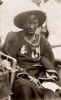
Ngalifourou was a queen of the Mbé region in what is today the Republic of Congo(Congo-Brazzaville). As a ruler she was close to French colonial authorities and was the first ruler in her region to sign a treaty with them. An important spiritual figure, as well as a royal one, her funeral was used as a tool by the French regime to try and resist its decline.

The history of Central Africa has been divided into its prehistory, its ancient history, the major polities flourishing, the colonial period, and the post-colonial period, in which the current nations were formed. Central Africa is the central region of Africa, bordered by North Africa, West Africa, East Africa, Southern Africa, the Atlantic Ocean, and the Sahara Desert. Colonial boundaries are reflected in the modern boundaries between contemporary Central African states, cutting across ethnic and cultural lines, often dividing single ethnic groups between two or more states.


