Bath is the largest city in the ceremonial county of Somerset, England, known for its Roman-built baths. In 2011, the population was 88,859. Bath is in the valley of the River Avon, 97 miles (156 km) west of London and 11 miles (18 km) south-east of Bristol. The city became a World Heritage site in 1987.

Corsham is a historic market town and civil parish in west Wiltshire, England. It is at the south-western edge of the Cotswolds, just off the A4 national route, which was formerly the main turnpike road from London to Bristol, 28 miles (45 km) southwest of Swindon, 20 miles (32 km) southeast of Bristol, 8 miles (13 km) northeast of Bath and 4 miles (6 km) southwest of Chippenham. Corsham is close to the county borders with Bath and North East Somerset and South Gloucestershire.

Great Pulteney Street is a grand thoroughfare that connects Bathwick on the east of the River Avon with the City of Bath, England via the Robert Adam designed Pulteney Bridge. Viewed from the city side of the bridge the road leads directly to the Holburne Museum of Art that was originally the Sydney Hotel where tea rooms, card rooms, a concert room and a ballroom were installed for the amusement of Bath's many visitors.
There are 212 Grade II* listed buildings in Bristol, England.

The Grade I listed buildings in Somerset, England, demonstrate the history and diversity of its architecture. The ceremonial county of Somerset consists of a non-metropolitan county, administered by Somerset County Council, which is divided into five districts, and two unitary authorities. The districts of Somerset are West Somerset, South Somerset, Taunton Deane, Mendip and Sedgemoor. The two administratively independent unitary authorities, which were established on 1 April 1996 following the breakup of the county of Avon, are North Somerset and Bath and North East Somerset. These unitary authorities include areas that were once part of Somerset before the creation of Avon in 1974.
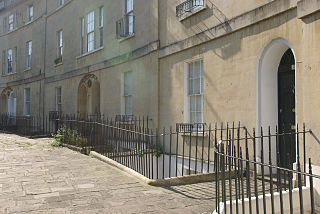
Widcombe is a district of Bath, England, immediately south-east of the city centre, across the River Avon.

Bath and North East Somerset is a unitary authority created on 1 April 1996, following the abolition of the County of Avon, which had existed since 1974. Part of the ceremonial county of Somerset, Bath and North East Somerset occupies an area of 220 square miles (570 km2), two-thirds of which is green belt. It stretches from the outskirts of Bristol, south into the Mendip Hills and east to the southern Cotswold Hills and Wiltshire border. The city of Bath is the principal settlement in the district, but BANES also covers Keynsham, Midsomer Norton, Radstock and the Chew Valley. The area has a population of 170,000, about half of whom live in Bath, making it 12 times more densely populated than the rest of the area.

Over United Reformed Church is in Swanlow Lane, Over, Winsford, Cheshire, England. It was built as a Congregational chapel and is now a United Reformed Church. It is a Grade II listed building,

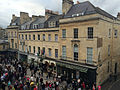
Milsom Street in Bath, Somerset, England was built in 1762 by Thomas Lightholder. The buildings were originally grand town houses, but most are now used as shops, offices and banks. Most have three storeys with mansard roofs and Corinthian columns.

Henrietta Street in the Bathwick area of Bath, Somerset, England was built around 1785 by Thomas Baldwin.

Johnstone Street in the Bathwick area of Bath, Somerset, England was designed in 1788 by Thomas Baldwin, with some of the buildings being completed around 1805-1810 by John Pinch the elder.
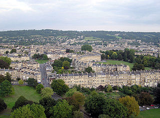
The buildings and architecture of Bath, a city in Somerset in the south west of England, reveal significant examples of the architecture of England, from the Roman Baths, to the present day. The city became a World Heritage Site in 1987, largely because of its architectural history and the way in which the city landscape draws together public and private buildings and spaces. The many examples of Palladian architecture are purposefully integrated with the urban spaces to provide "picturesque aestheticism". It is the only entire city in Britain to achieve World Heritage status, and is a popular tourist destination.
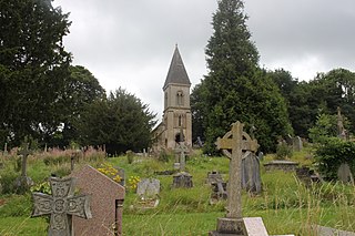
The Anglican Bath Abbey Cemetery, officially dedicated as the Cemetery of St Peter and St Paul, was laid out by noted cemetery designer and landscape architect John Claudius Loudon (1783–1843) in 1843 on a picturesque hillside site overlooking Bath, Somerset, England. The cemetery was laid out between 1843 and 1844.

Robertsbridge United Reformed Church is a former United Reformed Church place of worship in Robertsbridge, a village in the district of Rother in the English county of East Sussex. Built for Congregational worshippers in 1881 following their secession from a long-established Wesleyan Methodist chapel, it was the third Nonconformist place of worship in the village, whose nearest parish church was in the neighbouring settlement of Salehurst. Like the former Strict Baptist and Methodist chapels in the village, which have both closed, it no longer serves Robertsbridge as a place of worship. Local architect Thomas Elworthy's distinctive design—a "rich" and highly decorated blend of several styles—has divided opinion amongst architectural historians. English Heritage has listed the church at Grade II for its architectural and historical importance.

The United Reformed Church is a congregation in Stamford, Lincolnshire, based in a late-Georgian building situated on Star Lane.

The Crescent is a street in Taunton, a town in the English county of Somerset. Construction began in 1807, during a period of extensive redevelopment in the town, driven by the Market House Society and the Member of Parliament Sir Benjamin Hammet. Lined on the eastern side by a Georgian terrace, the street follows a shallow crescent shape, broken in the middle by Crescent Way and a bit further south by St George's Place. It links Upper High Street, at its southern end, with Park Street and Tower Street to the north. On the western side, Somerset County Council have their offices in the County Hall, erected in 1935, and extended in the 1960s. The Georgian terrace, the Masonic Hall, and the County Hall are recorded in the National Heritage List for England as listed buildings.

The building formerly known as Godalming Congregational Church was the Congregational chapel serving the ancient town of Godalming,in the English county of Surrey, between 1868 and 1977. It superseded an earlier chapel, which became Godalming's Salvation Army hall, and served a congregation which could trace its origins to the early 18th century. The "imposing suite of buildings", on a major corner site next to the Town Bridge over the River Wey, included a schoolroom and a manse, and the chapel had a landmark spire until just before its closure in 1977. At that time the congregation transferred to the nearby Methodist chapel, which became a joint Methodist and United Reformed church with the name Godalming United Church. The former chapel then became an auction gallery before being converted into a restaurant; then in 2018 the premises were let to the Cotswold Company to be converted into a furniture and home accessories showroom. In 1991 the former chapel was listed at Grade II for its architectural and historical importance.