
Nzega District is one of the seven districts of the Tabora Region of Tanzania. It is bordered to the north by Shinyanga Region, to the south and southwest by the Uyui District and to the east by the Igunga District. Its administrative seat is the town of Nzega.

Karatu District is one of the seven districts in the Arusha Region of Tanzania. It is bordered by the Ngorongoro District to the north, the Shinyanga Region to the west, the Monduli District to the east, and the Manyara Region to the south and southeast.
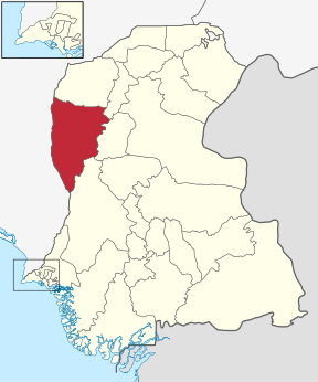
Nkasi District is one of the four districts of the Rukwa Region of Tanzania, with its headquarters in the village of Namanyere. It is bordered to the north by the Mpanda District of Katavi Region; to the east by the Sumbawanga Urban District; to the south by the Sumbawanga Rural District and Zambia; and to the west by Lake Tanganyika across from the Democratic Republic of Congo.
Dadu District, is a district of Sindh Province, Pakistan. Dadu District was created in 1931 by merging Kotri and Mahal Kohistan tehsils from Karachi District and Mehar, Khairpur Nathan Shah, Dadu, Johi and Sehwan tehsils from Larkana District. IN 2004, several talukas in the south were split off to create the new Jamshoro District. Its boundary touches with four districts of Sindh i.e. Jamshoro, Naushahro Feroze, Shaheed Benazirabad and Kamber Shahdadkot.

Negele Borana is a town and separate woreda in southern Ethiopia. Located in the Guji Zone of the Oromia Region on the road connecting Addis Ababa to Dolo Odo, it is the largest town in the region traditionally inhabited by the Borana Oromo. It has a latitude and longitude of 5°20′N39°35′E with an altitude of about 1,475 meters above sea level. Negele Borana's principal importance is that a barrack revolt in this town is considered the first incident of the Ethiopian Revolution.
Gursum is one of the woredas in the Somali Region of Ethiopia. Part of the Jijiga Zone, Gursum is bordered on the south by Babille, on the west by the Oromia Region, on the north by Ajersagora, on the east by Jijiga, and on the southeast by Kebri Beyah. Information is not available on the towns of this woreda.
Tole is one of the woredas in the Oromia Region of Ethiopia. Part of the Debub Mirab Shewa Zone, it is bordered on the southwest by Kokir, on the west by Becho, on the northwest by Elu, on the northeast by the Awash which separates it from Alem Gena, and on the east and south by Kersana Kondaltiti. The major town in Tole is Bentu Liben.

Aguilar de Bureba is a municipality and town located in the province of Burgos, Castile and León, Spain. According to the 2004 census (INE), the municipality has a population of 75 inhabitants.

Kilomeni is a ward in the Mwanga District of the Kilimanjaro Region of Tanzania and is situated in the Pare Mountains. Kilomeni is home to a Roman Catholic parish, a secondary school, and a primary school. According to the 2012 census, the population of the ward was 4,467. The local people of kilomeni are The Pare.

The Electoral district of Colac was an electoral district of the Victorian Legislative Assembly, one of the inaugural districts of the first Assembly in 1856.

Gò Công Tây is a rural district (huyện) of Tiền Giang Province in the Mekong Delta region of Vietnam, was established in 13 April 1979. As of 2003 the district had a population of 166,487. The district covers an area of 272 km². The district capital lies at Vĩnh Bình.
Poli is an administrative ward in the Arumeru district of the Arusha Region of Tanzania. According to the 2002 census, the ward has a total population of 8,659.
Karatu is an administrative ward in the Karatu District of the Arusha Region of Tanzania. According to the 2002 census, the ward has a total population of 17,922.
Makuro is an administrative ward in the Singida Rural district of the Singida Region of Tanzania. According to the 2002 census, the ward has a total population of 15,533.
São Benedito do Rio Preto is a municipality in the state of Maranhão in the Northeast region of Brazil.
Cândido de Abreu is a municipality in the state of Paraná in the Southern Region of Brazil.

Sarar District is a district of the Abyan Governorate, Yemen. As of 2003, the district had a population of 15,093 inhabitants.
Ilembula is a town and ward in Njombe district in the Iringa Region of the Tanzanian Southern Highlands. Its population according to the 2002 Tanzanian census is 18,126.

Yozgat is an electoral district of the Grand National Assembly of Turkey. It elects 4 members of parliament (deputies) to represent the province of the same name for a four-year term by the D'Hondt method, a party-list proportional representation system.


