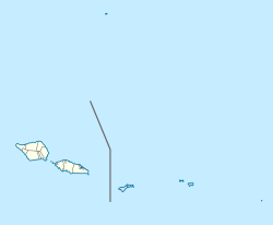
Afega is a village on the island of Upolu in Samoa. It is located on the central north coast of the island to the west of the capital Apia in the countryside. The population is 1,781.
Tuana'i is a small village on the central north coast of Upolu island in Samoa. It is situated to the west of Apia, the country's capital. The population is 1,247.
Letogo is a village on the central north coast of Upolu island in Samoa. Letogo is situated east of the capital Apia.
Lalomalava is a village at the southeast end of Savai'i island in Samoa. The village is part of the electoral constituency Fa'asaleleaga I which is within the larger political district (Itumalo) of Fa'asaleleaga.

Sapapali'i is a village on the north east coast of Savai'i island in Samoa. It is the village where John Williams, the first missionary to bring Christianity to Samoa landed in 1830. Sapapali'i is in the Fa'asaleleaga political district.
Fa'ato'ialemanu is a village on the island of Upolu in Samoa. It is situated on the north central side of the island near the country's capital Apia. The village is in the political district of Tuamasaga.
Sapulu is a village at the east side of Savai'i island in Samoa. The village is part of the electoral constituency Fa'asaleleaga I which is within the larger political district (Itumalo) of Fa'asaleleaga.
Tino i Iva The Village of Uncle Bully, is a village at the east end of Savai'i island in Samoa. The village is part of the electoral constituency Fa'asaleleaga I which is within the larger political district (Itumalo) of Fa'asaleleaga.
Falefia is a village at the east end of Savai'i island in Samoa. The village is part of the electoral constituency Fa'asaleleaga I which is within the larger political district (Itumalo) of Fa'asaleleaga.
Vaiafai is a village at the east end of Savai'i island in Samoa. The village is part of the electoral constituency Fa'asaleleaga I which is within the larger political district (Itumalo) of Fa'asaleleaga.
Salelavalu Tai is a village at the east end of Savai'i island in Samoa. The village is part of the electoral constituency Fa'asaleleaga I which is within the larger political district (Itumalo) of Fa'asaleleaga.
Salelavalu Uta is a village at the east end of Savai'i island in Samoa. The village is part of the electoral constituency Fa'asaleleaga I which is within the larger political district (Itumalo) of Fa'asaleleaga.
Vaimaga is a village at the east end of Savai'i island in Samoa. The village is part of the electoral constituency Fa'asaleleaga II which is within the larger political district (Itumalo) of Fa'asaleleaga.
Sa'asa'ai is a village at the east end of Savai'i island in Samoa. The village is part of the electoral constituency Fa'asaleleaga III which is within the larger political district (Itumalo) of Fa'asaleleaga.
Saipipi is a village at the east end of Savai'i island in Samoa. The village is part of the electoral constituency Fa'asaleleaga III which is within the larger political district (Itumalo) of Fa'asaleleaga.
Lano is a village on the north east coast of Savai'i island in Samoa. The village is part of the electoral constituency Fa'asaleleaga IV which is within the larger political district (Itumalo) of Fa'asaleleaga.
Fogapoa is a village on the north east coast of Savai'i island in Samoa. The village is part of the electoral constituency Fa'asaleleaga II which is within the larger political district (Itumalo) of Fa'asaleleaga.

Lelepa is a village on the north central coast of Savai'i island in Samoa. The village is part of the electoral constituency Gaga'emauga III which forms part of the larger political district of Gaga'emauga.