Blue Ridge is a city in Fannin County, Georgia, United States. As of the 2020 census, the city had a population of 1,253. The city is the county seat of Fannin County.

McCaysville is a city in Fannin County, Georgia, United States. The population was 1,149 at the 2020 census.

Copperhill is a city in Polk County, Tennessee, United States. The population was 443 at the 2020 census. It is included in the Cleveland Metropolitan Statistical Area.
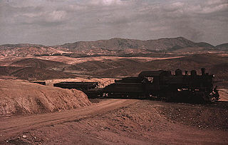
The Georgia Northeastern Railroad is a short line freight railroad which runs from the town of Elizabeth, Georgia to the city of Blue Ridge, Georgia. Goods hauled are mostly timber, grain, poultry, and marble products. The GNRR's subsidiary, the Blue Ridge Scenic Railway, also operates on this line north of Blue Ridge. Despite the name, it actually operates between north-central and northwest Georgia, from north-northwest metro Atlanta, and is a few counties away from northeast Georgia.

The Blue Ridge Scenic Railway is a heritage railroad in northern Georgia.

The Toccoa River and Ocoee River are the names in use for a single 93-mile-long (150 km) river that flows northwestward through the southern Appalachian Mountains of the southeastern United States. It is a tributary of the Hiwassee River, which it joins in Polk County, Tennessee, near the town of Benton. Three power generating dams are operated along it.

U.S. Route 411 (US 411) is an alternate parallel-highway associated with US 11. It extends for about 309.7 miles (498.4 km) from US 78 in Leeds, Alabama, to US 25W/US 70 in Newport, Tennessee. US 411 travels through northeastern Alabama, northwestern Georgia, and southeastern Tennessee. It is signed north-south, as with most highways that have odd numbers, but the route runs primarily in a northeast-southwest direction, and covers a more east-west mileage than it does north-south. Notable towns and cities along its route include Gadsden, Alabama; Rome, Georgia; Cartersville, Georgia; Maryville, Tennessee; Sevierville, Tennessee, and Newport, Tennessee.

The Tennessee Valley Railroad Museum is a railroad museum and heritage railroad in Chattanooga, Tennessee.

State Route 5 (SR 5) is a 155.325-mile-long (249.971 km) state highway that travels south-to-north through portions of Carroll, Douglas, Cobb, Cherokee, Pickens, Gilmer, and Fannin counties in the western and northern parts of the U.S. state of Georgia. The highway travels from its southern terminus at SR 48 at the Alabama state line, north-northwest of Ephesus, to its northern terminus at SR 60 and SR 68 at the Tennessee state line on the McCaysville–Copperhill line, bisecting the northwestern portion of the state.

The East Tennessee, Virginia and Georgia Railroad (ETV&G) was a rail transport system that operated in the southeastern United States during the late 19th century. Created with the consolidation of the East Tennessee and Virginia Railroad and the East Tennessee and Georgia Railroad in 1869, the ETV&G played an important role in connecting East Tennessee and other isolated parts of Southern Appalachia with the rest of the country, and helped make Knoxville one of the region's major wholesaling centers. In 1894, the ETV&G merged with the Richmond and Danville Railroad to form the Southern Railway.

The Southern Highroads Trail is a 364-mile-long (586 km) loop of scenic and historic highways in the Southeastern United States. The driving trail traverses 14 counties, four states, and four national forests, providing sightseers and passersby an array of culinary, hotel, shopping, and recreational options along the way.

Hiwassee Dam is a hydroelectric dam on the Hiwassee River in Cherokee County, in the U.S. state of North Carolina. It is one of three dams on the river owned and operated by the Tennessee Valley Authority, which built the dam in the late 1930s to bring flood control and electricity to the region. The dam impounds the Hiwassee Lake of 6,000 acres (2,400 ha), and its tailwaters are part of Apalachia Lake. At 307 feet (94 m), Hiwassee Dam is the highest overspill dam in the Eastern United States and third only to Shasta and Grand Coulee dams in the nation. At the time it was completed, it was the highest overspill dam in the world.

U.S. Route 76 (US 76) is a 150.7-mile-long (242.5 km) east–west U.S. highway in the U.S. state of Georgia. It begins at the Tennessee state line, east of Lakeview, Georgia, where the roadway continues concurrent with US-41/SR-8 toward Chattanooga. It ends at the South Carolina state line, where US 76 continues toward Anderson. In Georgia, the highway travels within portions of Catoosa, Whitfield, Murray, Gilmer, Fannin, Union, Towns, and Rabun counties. It travels through North Georgia and connects Ringgold, Dalton, Chatsworth, Ellijay, Blue Ridge, Blairsville, and Clayton. Most of the highway is part of the Lookout Mountain Scenic Highway, a highway that travels through northern Georgia and through the Chattahoochee-Oconee National Forest.
The Carolina, Knoxville and Western Railway was a South Carolina railroad that existed in the latter half of the 19th century.

State Route 33 is a primary and secondary route in East Tennessee. It runs 176 miles, from the Georgia state line in Polk County, northeast to the Virginia state line north of Kyles Ford in Hancock County. South of Maryville, SR 33 is a "hidden" route which shares a concurrency with US 411.

State Route 68 (SR 68) is a 106.89-mile-long (172.02 km) state highway in the eastern part of the U.S. state of Tennessee.

The Greenback Depot is a former railroad station located in Greenback, Tennessee, United States. Built in 1914 by the Louisville and Nashville Railroad (L&N), the depot served rail freight and passengers traveling in and out of the Greenback area until 1954. Restored for use as a community events center by Ronald Edmondson in the early 2010s, the depot was listed on the National Register of Historic Places in 2013 in recognition of its role in the area's transportation history.
The Marietta depot is a former freight and passenger stop in Marietta, Georgia. It was originally built in 1864 for the Western and Atlantic Railroad, a railroad between Chattanooga, Tennessee and Atlanta, Georgia. That railroad was absorbed by the Nashville, Chattanooga and St. Louis Railway. In turn, the latter railroad was merged into the Louisville and Nashville Railroad in 1957.
The Copper Basin, also known as the Ducktown Basin, is a geological region located primarily in Polk County, Tennessee that contains deposits of copper ore and covers approximately 60,000 acres. Located in the southeastern corner of Tennessee, small portions of the basin extend into Fannin County, Georgia and Cherokee County, North Carolina. The basin is surrounded by the Cherokee National Forest and the cities of Ducktown and Copperhill, Tennessee and McCaysville, Georgia are located in the basin.