Boisbriand is an off-island suburb of Montreal, in southwestern Quebec, Canada, on the north shore of the Rivière des Mille-Îles in the Thérèse-De Blainville Regional County Municipality.
The Tramways vicinaux or Buurtspoorwegen were a system of narrow-gauge tramways or local railways in Belgium, which covered the whole country and had a greater route length than the mainline railway system. They were 1,000 mm gauge and included electrified city lines and rural lines using steam locomotives and diesel railcars; half the system was electrified.
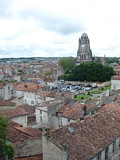
Saintes is a commune and historic town in southwestern France, in the Charente-Maritime department of which it is a sub-prefecture, in Nouvelle-Aquitaine. Its inhabitants are called Saintaises and Saintais. Saintes is the second-largest city in Charente-Maritime, with 26,470 inhabitants in 2008. Its immediate surrounds form the second-most populous metropolitan area in the department, with 56,598 inhabitants, the majority of which is fertile, productive fields; a significant minority of the region remains forest, its natural state.
The Chemins de Fer du Nord, often referred to simply as the Nord company, was a rail transport company created in September 1845, in Paris, France. It was owned by among others de Rothschild Frères of France, N M Rothschild & Sons of London, England, Hottinger, Laffitte and Blount. Baron James de Rothschild served as the company's first president from its inception until his death in 1868.
The Compagnie des chemins de fer de l'Ouest, often referred to simply as L'Ouest or Ouest, was an early French railway company.

Gouin Boulevard is the longest street on the Island of Montreal, stretching 50 kilometres (31 mi) across the north side of the island from Senneville in the west to Pointe-aux-Trembles in the east, where it intersects with Sherbrooke Street.

Pierre-Dominique "Adolphe" Bazaine, was a French railway engineer. He was a regional engineer with the highways department at Altkirch, subsequently becoming director of railways for Alsace Fichier:Strasbourg-Bâle P-D Bazaine.jpg
In France, a voie ferrée d'intérêt local, abbreviated VFIL, is a secondary railway constructed by a local administrative division, serving sparsely populated rural areas. These areas were beyond the economic reach of the networks of the intérêt général, which were concessions of the grandes compagnies who ran their lines for profit.

The railway from Paris to Lille is an important French 251-kilometre long railway line, that connects Paris to the northern French city Lille. Branch lines offer connections to Belgium and Great Britain. As one of the first railway lines in France, it was opened on 20 June 1846. The opening of the LGV Nord high speed line from Paris to Lille in 1993 has decreased its importance for passenger traffic.

The railway from Strasbourg to Basel is a French and Swiss 141.3-kilometre long railway line. It is used for passenger and freight traffic. The railway was opened in 1840-1844.
The railway from Bordeaux to Irun is an important French 235-kilometre long railway line, that connects the southwestern city Bordeaux to northern Spain. The railway was opened in several stages between 1841 and 1864.

The history of rail transport in Luxembourg began in 1846 and continues to the present day.
The Société des Transports Intercommunaux de Charleroi, abbreviated and referred to as STIC, was a company operating a local and regional public transport network in Charleroi, Belgium. The company was active from 1962 until 1991, when it was merged with the Charleroi part of the SNCV to form the TEC Charleroi, the current public transport company in Charleroi.
The Belgian State Railways, sometimes referred to as the Belgian State Railway, was the original state-owned railway of Belgium. Established by an organic law of 1 May 1834, it began construction of its first line, between Brussels-Groendreef/Allée verte and Mechelen, on 1 June 1834. This line, which was opened on 5 May 1835, was also the first steam-powered public railway in continental Europe.
Luxembourg has a rich history of narrow-gauge railways. A few industrial and mining railways survive.

Chemins de fer des Uele is a 600 mm narrow-gauge line in the north east of the Democratic Republic of the Congo. It was built between 1924 and 1937 as a portage railway bypassing Congo River rapids.

The Mayumbe line was a 140 km (87 mi) long 610 mm gauge narrow gauge railway in the north west of the Democratic Republic of the Congo between the port of Boma and Tshela.

Gare de Dachstein is a French railway station located on the Strasbourg–Saint-Dié railway. It is located in the communes of Dachstein and Molsheim, in departement Bas-Rhin, in northeastern France.

Gare de Duppigheim is a French railway station located on the Strasbourg–Saint-Dié railway. It is located within the commune of Duppigheim, close to the village of Kolbsheim, in departement Bas-Rhin, in northeastern France. It serves the economic zone of the Bruche plains.
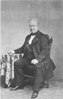
Stéphane Christophe Mony was a French railway engineer, company president and politician. He was involved in the Saint-Simonian movement when a young man. He was trained as an engineer, and he and his half brother Eugène Flachat built the Paris-Saint Germain and Paris-Versailles railway lines between 1833 and 1840. He was then appointed head of the Commentry mining company, later Commentry-Fourchambault, a position he held until his death. He was elected to the legislature towards the end of the Second French Empire, from 1868 to 1870. He did not succeed in getting reelected in the French Third Republic.