Samantha Reed Smith was an American peace activist and child actress from Manchester, Maine, who became famous for her anti-war outreaches during the Cold War between the United States and the Soviet Union. In 1982, Smith wrote a letter to the newly appointed General Secretary of the Communist Party of the Soviet Union, Yuri Andropov, and received a personal reply with an invitation to visit the Soviet Union, which she accepted.

Long Beach Airport is a public airport three miles northeast of downtown Long Beach, in Los Angeles County, California, United States. It is also called Daugherty Field, named after local aviator Earl Daugherty. The airport was an operating base for JetBlue, but this ended on October 6, 2020, as the carrier moved its operating base to Los Angeles International Airport, amidst the then-ongoing COVID-19 pandemic. Consequently, Southwest Airlines became the airport's largest airline.

Boise Airport is a joint civil-military airport in the western United States in Idaho, three miles (5 km) south of downtown Boise in Ada County. The airport is operated by the city of Boise Department of Aviation, overseen by an airport commission. The busiest airport in the state, it serves more passengers than all other Idaho airports combined and roughly ten times as many passengers as the next busiest airport at Idaho Falls.
Groton–New London Airport is a state-owned public-use airport located three nautical miles (6 km) southeast of the central business district of Groton, a town in New London County, Connecticut, United States. It is included in the Federal Aviation Administration (FAA) National Plan of Integrated Airport Systems for 2017–2021, in which it is categorized as a regional general aviation facility. It serves the southeastern Connecticut region, including the shoreline localities of Groton, New London, and Mystic.

Greater Binghamton Airport is a county-owned American airport eight miles north of Binghamton, in Broome County, New York. It is in East Maine, New York and serves the Southern Tier of New York.

Knox County Regional Airport is a county-owned, public-use airport in the town of Owls Head, Knox County, Maine, United States. It is located three nautical miles (6 km) south of the central business district of Rockland, Maine. The airport serves the residents of midcoast Maine with commercial and charter aviation services. Scheduled airline service is subsidized by the Essential Air Service program. It is also a major hub of freight and mail service to Maine's island communities including Matinicus, North Haven and Vinalhaven.

Presque Isle International Airport, formally Northern Maine Regional Airport at Presque Isle, is a mile northwest of Presque Isle, in Aroostook County, Maine, United States. It serves the residents of Presque Isle and a vast area of northern Maine and northwestern New Brunswick. Airline flights to Newark Liberty International Airport are subsidized by the federal government's Essential Air Service program at a cost of $3,892,174.

Hancock County–Bar Harbor Airport is a county-owned, public-use airport located in Trenton, Maine, eight nautical miles northwest of the central business district of Bar Harbor, a city in Hancock County, Maine, United States. It serves the residents of Hancock County with commercial and charter aviation services. During the summer months, the airport becomes one of Maine's busiest, with significant private jet operations bringing visitors to the numerous summer colonies in the county, which includes Mount Desert Island. Scheduled passenger airline service is subsidized by the Essential Air Service program.

New Bedford Regional Airport is a Part 139 Commercial-Service Airport, municipally-owned and available for public use. The airport is located three nautical miles northwest of the City of New Bedford, a city in Bristol County, Massachusetts, United States.
Dothan Regional Airport is a public airport in Dale County, Alabama, United States, seven miles northwest of Dothan, a city mostly in Houston County.

Montgomery Regional Airport is a civil-military airport seven miles southwest of Montgomery, the capital of Alabama. Owned by the Montgomery Airport Authority, it is used for general aviation and military aviation, and sees two airlines.
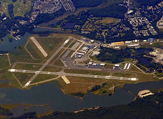
Portsmouth International Airport at Pease, formerly known as Pease International Airport, is a joint civil and military use airport located one nautical mile (2 km) west of the central business district of Portsmouth, a city in Rockingham County, New Hampshire, United States. It is owned by the Pease Development Authority. It is included in the Federal Aviation Administration (FAA) National Plan of Integrated Airport Systems for 2017–2021, in which it is categorized as a non-hub primary commercial service facility.

Daytona Beach International Airport is a county-owned airport located three miles (5 km) southwest of Daytona Beach, next to Daytona International Speedway, in Volusia County, Florida, United States. The airport has 3 runways, a six-gate domestic terminal, and an international terminal. Daytona Beach is the headquarters of Embry-Riddle Aeronautical University.

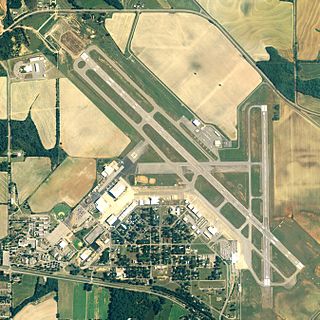
Pullman–Moscow Regional Airport is a public airport in the northwest United States, located in Whitman County, Washington, two miles (3 km) east of Pullman, Washington and four miles (6 km) west of Moscow, Idaho. The airport is accessed via spurs from State Route 270, and has a single 7,101-foot (2,164 m) runway, headed northeast–southwest (5/23), which entered service in October 2019. The former runway (6/24) was 6,730 feet (2,051 m) and aligned with Moscow Mountain twelve miles (20 km) to the northeast, the highest summit in the area.

Felts Field is a public airport in the northwest United States, located five miles (8 km) northeast of downtown Spokane, in Spokane County, Washington. It is owned by Spokane City-County.

Bar Harbor Airlines Flight 1808 was a scheduled flight from Logan International Airport to Bangor International Airport in the United States on August 25, 1985. On final approach to Auburn/Lewiston Municipal Airport, the Bar Harbor Airlines Beechcraft Model 99 crashed short of the runway, killing all six passengers and two crew on board. Among the passengers was Samantha Smith, a 13-year-old American schoolgirl who had become famous as a goodwill ambassador to the Soviet Union and had been cast on the television show Lime Street.

Northeast Florida Regional Airport, is located approximately four miles (6 km) north of historic St. Augustine, in St. Johns County, Florida, United States. NFRA serves as a key connection point for air travel in the Northeast Florida region. It is a public airport managed by the St. Johns County Airport Authority on behalf of the citizens of St. Johns County. Airport facilities include both commercial and general aviation terminals.
Sanford Seacoast Regional Airport is a public airport located four miles (6 km) southeast of the central business district of Sanford, a town in York County, Maine, United States. The airport operated as Naval Auxiliary Air Facility Sanford supporting operations of Naval Air Station Brunswick from 15 April 1943 until 1 February 1946. This airport is now publicly owned by the City of Sanford.

Richard B. Russell Airport is a county-owned public-use airport in Floyd County, Georgia, United States. The airport is located six nautical miles (11 km) north of the central business district of Rome, Georgia. It is also known as Richard B. Russell Regional Airport.

Portland International Jetport is a public airport two miles (3 km) west of downtown Portland, Maine, United States. It is owned and operated by the City of Portland. A portion of the Jetport's property, including the main runway, is located within the neighboring city of South Portland. PWM covers 726 acres of land.